Saint-Hubert-de-Rivière-du-Loup
Saint-Hubert-de-Rivière-du-Loup (French pronunciation: [sɛ̃.t‿ybɛʁ də ʁivjɛʁ dy lu]) is a municipality in Quebec, Canada, in the administrative region of Bas-Saint-Laurent and the regional county municipality of Rivière-du-Loup.
Saint-Hubert-de-Rivière-du-Loup | |
|---|---|
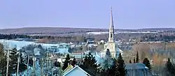 Westward view from Chemin Taché | |
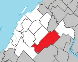 Location within Rivière-du-Loup RCM | |
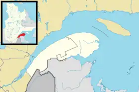 Saint-Hubert-de-Rivière-du-Loup Location in eastern Quebec | |
| Coordinates: 47°49′N 69°09′W[1] | |
| Country | |
| Province | |
| Region | Bas-Saint-Laurent |
| RCM | Rivière-du-Loup |
| Constituted | January 4, 1894 |
| Government | |
| • Mayor | Napoléon Lévesque |
| • Federal riding | Montmagny—L'Islet—Kamouraska—Rivière-du-Loup |
| • Prov. riding | Rivière-du-Loup-Témiscouata |
| Area | |
| • Total | 198.60 km2 (76.68 sq mi) |
| • Land | 192.20 km2 (74.21 sq mi) |
| Population | |
| • Total | 1,412 |
| • Density | 7.3/km2 (19/sq mi) |
| • Pop 2016-2021 | |
| • Dwellings | 1,019 |
| Time zone | UTC−5 (EST) |
| • Summer (DST) | UTC−4 (EDT) |
| Postal code(s) | |
| Area code(s) | 418 and 581 |
| Highways | |
| Website | www |
Notable people
- Leo Kerouac, father of author and poet Jack Kerouac
See also
References
- "Reference number 333303 in Banque de noms de lieux du Québec". toponymie.gouv.qc.ca (in French). Commission de toponymie du Québec.
- "Geographic code 12010 in the official Répertoire des municipalités". www.mamh.gouv.qc.ca (in French). Ministère des Affaires municipales et de l'Habitation.
- "Data table, Census Profile, 2021 Census of Population - Saint-Hubert-de-Rivière-du-Loup, Municipalité (MÉ) [Census subdivision], Quebec". 9 February 2022.
External links
 Media related to Saint-Hubert-de-Rivière-du-Loup at Wikimedia Commons
Adjacent Municipal Subdivisions | ||||||||||||||||
|---|---|---|---|---|---|---|---|---|---|---|---|---|---|---|---|---|
| ||||||||||||||||
| Cities & Towns | |
|---|---|
| Municipalities | |
| Parishes | |
| |
This article is issued from Wikipedia. The text is licensed under Creative Commons - Attribution - Sharealike. Additional terms may apply for the media files.