Saint-Jean-la-Vêtre
Saint-Jean-la-Vêtre (French pronunciation: [sɛ̃ ʒɑ̃ la vɛtʁ]; Arpitan: Sent-Jian-Lavètre) is a commune in the Loire department in central France.[3]
Saint-Jean-la-Vêtre | |
|---|---|
Commune | |
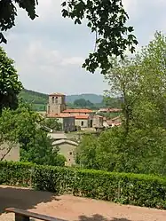 | |
.svg.png.webp) Coat of arms | |
Location of Saint-Jean-la-Vêtre | |
 Saint-Jean-la-Vêtre  Saint-Jean-la-Vêtre | |
| Coordinates: 45°47′24″N 3°48′22″E | |
| Country | France |
| Region | Auvergne-Rhône-Alpes |
| Department | Loire |
| Arrondissement | Montbrison |
| Canton | Boën-sur-Lignon |
| Intercommunality | CA Loire Forez |
| Government | |
| • Mayor (2020–2026) | Jean-Luc Daval-Pommier[1] |
| Area 1 | 16.22 km2 (6.26 sq mi) |
| Population | 324 |
| • Density | 20/km2 (52/sq mi) |
| Time zone | UTC+01:00 (CET) |
| • Summer (DST) | UTC+02:00 (CEST) |
| INSEE/Postal code | 42238 /42440 |
| Elevation | 654–1,296 m (2,146–4,252 ft) (avg. 670 m or 2,200 ft) |
| 1 French Land Register data, which excludes lakes, ponds, glaciers > 1 km2 (0.386 sq mi or 247 acres) and river estuaries. | |
Population
|
|
See also
References
- "Répertoire national des élus: les maires". data.gouv.fr, Plateforme ouverte des données publiques françaises (in French). 2 December 2020.
- "Populations légales 2020". The National Institute of Statistics and Economic Studies. 29 December 2022.
- INSEE commune file
Wikimedia Commons has media related to Saint-Jean-la-Vêtre.
This article is issued from Wikipedia. The text is licensed under Creative Commons - Attribution - Sharealike. Additional terms may apply for the media files.