Sainte-Hélène-de-Kamouraska
Sainte-Hélène-de-Kamouraska is a municipality in the Canadian province of Quebec, located in the Kamouraska Regional County Municipality.
Sainte-Hélène-de-Kamouraska | |
|---|---|
 | |
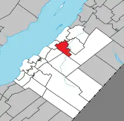 Location within Kamouraska RCM | |
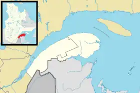 Sainte-Hélène-de-Kamouraska Location in eastern Quebec | |
| Coordinates: 47°36′N 69°44′W[1] | |
| Country | |
| Province | |
| Region | Bas-Saint-Laurent |
| RCM | Kamouraska |
| Constituted | July 1, 1855 |
| Government | |
| • Mayor | Louise Hémond |
| • Federal riding | Montmagny—L'Islet—Kamouraska—Rivière-du-Loup |
| • Prov. riding | Côte-du-Sud |
| Area | |
| • Total | 60.60 km2 (23.40 sq mi) |
| • Land | 60.46 km2 (23.34 sq mi) |
| Population | |
| • Total | 891 |
| • Density | 14.7/km2 (38/sq mi) |
| • Pop 2016-2021 | |
| • Dwellings | 410 |
| Time zone | UTC−5 (EST) |
| • Summer (DST) | UTC−4 (EDT) |
| Postal code(s) | |
| Area code(s) | 418 and 581 |
| Highways | |
| Website | sainte-helene |
Until September 13, 2014, it was officially known simply as Sainte-Hélène.[4]
Municipal council
- Mayor: Vacancy
- Councillors: Blaise Bérubé, Daniel Lajoie, Jacques Laplante, Joël Moreau, Jacques St-Pierre, plus a vacancy
See also
References
- "Reference number 398140 in Banque de noms de lieux du Québec". toponymie.gouv.qc.ca (in French). Commission de toponymie du Québec.
- "Geographic code 14025 in the official Répertoire des municipalités". www.mamh.gouv.qc.ca (in French). Ministère des Affaires municipales et de l'Habitation.
- "Data table, Census Profile, 2021 Census of Population - Sainte-Hélène-de-Kamouraska, Municipalité (MÉ) [Census subdivision], Quebec". 9 February 2022.
- "Modifications aux municipalités du Québec" (PDF). Modifications Aux Municipalités du Québec. Institut de la statistique du Québec. September 2014. ISSN 1715-6408.
External links
 Media related to Sainte-Hélène-de-Kamouraska at Wikimedia Commons
Adjacent Municipal Subdivisions | ||||||||||||||||
|---|---|---|---|---|---|---|---|---|---|---|---|---|---|---|---|---|
| ||||||||||||||||
| Cities and towns | |
|---|---|
| Municipalities | |
| Parishes | |
| Unorganized territories | |
| |
This article is issued from Wikipedia. The text is licensed under Creative Commons - Attribution - Sharealike. Additional terms may apply for the media files.