Sakaraha (district)
Sakaraha is a district located in Atsimo-Andrefana Region, south-western Madagascar.
Sakaraha | |
|---|---|
 | |
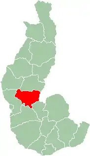 Map of former Toliara Province showing the location of Sakaraha (red). | |
| Country | Madagascar |
| Region | Atsimo-Andrefana |
Communes
The district is further divided into 11 communes:
Geography
Sakaraha is situated along route nationale No. 7 (Tuléar-Fianarantsoa) at 134 km from Tuléar, 64 km from Andranovory and 84 km from Ilakaka.[1] Zombitse-Vohibasia National Park is located in the district, east of the town of Sakaraha. Analavelona Massif is in the western portion of the district.
References
- Atlas Mondial, France Loisir, page 159
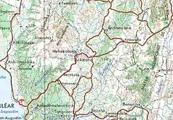
Area around Sakaraha, showing roads and topography
Capital: Toliara | ||
| Ampanihy Ouest (19) - 605 |  | |
| Ankazoabo - 606 - (10) |
| |
| Benenitra - 610 - (6) |
| |
| Beroroha - 611 - (9) |
| |
| Betioky-Atsimo -612 - (31) |
| |
| Morombe (9) - 618 | ||
| Sakaraha (12) - 620 | ||
| Toliara I (1) | ||
| Toliara II (22) (602) | ||
9 districts; 119 communes | ||
This article is issued from Wikipedia. The text is licensed under Creative Commons - Attribution - Sharealike. Additional terms may apply for the media files.