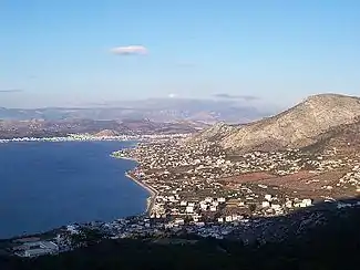
Salamina, Attica
Salamina (Greek: Σαλαμίνα, Katharevousa: Σαλαμίς, romanized: Salamís) or Kοullοuri (Greek: Κούλλουρη; Arvanitika: Kuluri)[2] is the largest city and a former municipality on Salamina Island in Greece. Since the 2011 local government reform it is part of the municipality of Salamina, of which it is the seat and a municipal unit.[3]
Salamina
Σαλαμίνα | |
|---|---|
 View of Salamina | |
 Seal | |
 Salamina | |
| Coordinates: 37°58′N 23°30′E | |
| Country | Greece |
| Administrative region | Attica |
| Regional unit | Islands |
| Municipality | Salamis |
| Districts | 2 |
| Government | |
| • Mayor | Georgios Panagopoulos |
| • Municipal unit | 80.992 km2 (31.271 sq mi) |
| Highest elevation | 375 m (1,230 ft) |
| Lowest elevation | 0 m (0 ft) |
| Population (2011)[1] | |
| • Municipal unit | 31,776 |
| • Municipal unit density | 390/km2 (1,000/sq mi) |
| Community | |
| • Population | 25,888 (2011) |
| Time zone | UTC+2 (EET) |
| • Summer (DST) | UTC+3 (EEST) |
| Postal code | 189 00 |
| Area code(s) | 21046 |
| Website | www.salamina.gr |
It is part of the Islands regional unit of the Attica region. The city lies in the northwestern part of the island. It had a population of 25,370 inhabitants at the 2011 census,[1] some of them are Arvanites.[2] It was the municipal seat of the former municipality of Salamina, which had a land area of 80.992 square kilometres (31.271 sq mi)[4] and comprised about 84 percent of the island (all except the easternmost central coast, which comprised the former municipality of Ampelakia). The population of the municipal unit was 31,776 in 2011. It includes several towns, the largest of which are Aiánteio (pop. 4,860), Stenó (198), Kanákia (206), Peristéria (206), Batsí (235), Kolónes (153), and Pérani (226).
Subdivisions
The municipal unit Salamina is subdivided into the following communities (constituent villages in brackets): Salamina (Salamina, Elliniko, Batsi, Steno) Aianteio (Aianteio, Dimitrani, Kanakia, Kolones, Maroudi, Perani, Peristeria)
Climate
According to the meteorological station of the National Observatory of Athens and Harokopio University, Salamina has hot semi-arid climate (Köppen climate classification: BSh) with mild winters and very hot summers.
| Climate data for Salamina | |||||||||||||
|---|---|---|---|---|---|---|---|---|---|---|---|---|---|
| Month | Jan | Feb | Mar | Apr | May | Jun | Jul | Aug | Sep | Oct | Nov | Dec | Year |
| Average high °C (°F) | 14.2 (57.6) |
15.8 (60.4) |
17.8 (64.0) |
21.9 (71.4) |
27.3 (81.1) |
32.0 (89.6) |
35.0 (95.0) |
35.2 (95.4) |
30.4 (86.7) |
24.9 (76.8) |
20.2 (68.4) |
16.0 (60.8) |
24.2 (75.6) |
| Daily mean °C (°F) | 10.9 (51.6) |
12.2 (54.0) |
13.8 (56.8) |
17.3 (63.1) |
22.4 (72.3) |
27.0 (80.6) |
29.9 (85.8) |
30.2 (86.4) |
26.0 (78.8) |
21.2 (70.2) |
17.0 (62.6) |
12.9 (55.2) |
20.1 (68.2) |
| Average low °C (°F) | 7.5 (45.5) |
8.6 (47.5) |
9.9 (49.8) |
12.7 (54.9) |
17.6 (63.7) |
21.9 (71.4) |
24.8 (76.6) |
25.3 (77.5) |
21.7 (71.1) |
17.4 (63.3) |
13.7 (56.7) |
9.9 (49.8) |
15.9 (60.6) |
| Average rainfall mm (inches) | 56.6 (2.23) |
33.5 (1.32) |
25.2 (0.99) |
22.0 (0.87) |
13.1 (0.52) |
24.0 (0.94) |
4.5 (0.18) |
3.1 (0.12) |
30.5 (1.20) |
27.9 (1.10) |
64.2 (2.53) |
49.3 (1.94) |
353.9 (13.94) |
| Source: National Observatory of Athens and Harokopio University (Jun 2016 - Jan 2023) [5][6] | |||||||||||||
See also
References
- "Απογραφή Πληθυσμού - Κατοικιών 2011. ΜΟΝΙΜΟΣ Πληθυσμός" (in Greek). Hellenic Statistical Authority.
- Jochalas, Titos P. (1971): Über die Einwanderung der Albaner in Griechenland: Eine zusammenfassene Betrachtung ["On the immigration of Albanians to Greece: A summary"]. München: Trofenik.
- "ΦΕΚ B 1292/2010, Kallikratis reform municipalities" (in Greek). Government Gazette.
- "Population & housing census 2001 (incl. area and average elevation)" (PDF) (in Greek). National Statistical Service of Greece.
- "Monthly Bulletins". www.meteo.gr.
- "Ο καιρός στη Σαλαμίνα - Weather conditions in Salamina".
External links
- Official website (in English and Greek)