San Juan–Caguas–Guaynabo metropolitan area
The San Juan metropolitan area is a United States Census Bureau defined metropolitan statistical area (MSA) in northeastern Puerto Rico centered around the city of San Juan.[1] A July 1, 2009, Census Bureau estimate placed the population at 2,617,089, a 4.31% increase over the 2000 census figure of 2,509,007.[2]
San Juan metropolitan area
Área metropolitana de San Juan San Juan–Caguas–Guaynabo metropolitan area | |
|---|---|
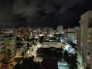
 View of Condado in Santurce, San Juan. | |
| Nickname(s): Área Metro, La Losa | |
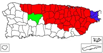
 Components of the San Juan metropolitan area are in red. | |
| Country | United States |
| Territory | Puerto Rico |
| Principal city | San Juan |
| Population (2020) | |
| • MSA | 2,202,708 |
| • CSA | 2,292,207 |
| Time zone | UTC−4 |
| • Summer (DST) | EDT |
San Juan Metro Area (Área Metro)

The unofficial but colloquial San Juan metropolitan area (in Spanish; área metropolitana de San Juan, abbreviated AMSJ), also referred to as the Área Metro is the sprawling area surrounding the Municipality of San Juan which includes San Juan and its conurbation of the municipalities of Bayamón, Carolina, Cataño, Guaynabo and Trujillo Alto, and in some cases it also includes Toa Baja (particularly the suburb of Levittown). After San Juan, many of these municipalities are the most populous in the commonwealth of Puerto Rico.[3] It represents the inner urban area of the metropolitan statistical area of San Juan. This urban area is also known as the Área metro de Puerto Rico based on the misconception that San Juan is the only urbanized metropolitan area in the island.
Municipalities in the San Juan–Caguas–Guaynabo metropolitan area

San Juan–Caguas–Guaynabo metropolitan area is the largest metropolitan area (by population) in Puerto Rico, covering approximately half of the island. Its principal cities are San Juan, Bayamón and Carolina.[1]
A total of forty-one municipalities (Spanish: municipios) are included as part of the San Juan–Caguas–Guaynabo MSA.[1][4][5] The total area for the MSA is 1,902.45 square miles. As of 2020, the San Juan metropolitan statistical area is the 35th most populated MSA (slightly smaller than Greater Cleveland but larger than San Jose metropolitan area in population).
Municipalities with over 100,000 inhabitants
Municipalities with 50,000 to 100,000 inhabitants
Municipalities with fewer than 50,000 inhabitants
- Río Grande Pop: 47,060
- Canóvanas Pop: 42,337
- Cayey Pop: 41,652
- Gurabo Pop: 40,662
- Cidra Pop: 39,970
- Manatí Pop: 39,492
- Hatillo Pop: 38,486
- San Lorenzo Pop: 37,693
- Juncos Pop: 37,012
- Dorado Pop: 35,879
- Vega Alta Pop: 35,395
- Las Piedras Pop: 35,180
- Corozal Pop: 34,571
- Camuy Pop: 32,827
- Yabucoa Pop: 30,426
- Naranjito Pop: 29,241
- Barranquitas Pop: 28,893
- Morovis Pop: 28,727
- Aibonito Pop: 24,637
- Aguas Buenas Pop: 24,223
- Loíza Pop: 23,693
- Quebradillas Pop: 23,638
- Naguabo Pop: 23,386
- Cataño Pop: 23,155
- Barceloneta Pop: 22,657
- Orocovis Pop: 21,434
- Comerío Pop: 18,883
- Ciales Pop: 16,984
- Florida Pop: 11,692
- Maunabo Pop: 10,589
Combined Statistical Area

The San Juan-Caguas-Fajardo Combined Statistical Area (CSA) includes two metropolitan areas, one micropolitan area, and forty-five municipalities. A July 1, 2009 Census Bureau estimate placed the population at 2,732,036, a 4.16% increase over the 2000 census figure of 2,622,876. The San Juan-Caguas-Fajardo Combined Statistical Area comprises 68.9% of Puerto Rico's total population.[6] As of 2020, the San Juan combined statistical area is the 29th largest CSA (slightly smaller than Indianapolis and larger than Las Vegas in population).
Components
- Metropolitan statistical areas (MSAs)
- Fajardo (3 municipalities)
- San Juan–Caguas–Guaynabo (41 municipalities)
- Micropolitan statistical areas (µSAs)
- Utuado micropolitan statistical area (1 municipality)
References
- www.whitehouse.gov Office of Management and Budget I The White House - Puerto Rico Metropolitan Statistical Area - Code 41980 - Revised Delineations of Metropolitan Statistical Areas as of 2013 Census Bureau. Retrieved 2015-11-09.
- "Table 3. Annual Estimates of the Population of Metropolitan and Micropolitan Statistical Areas in Puerto Rico: April 1, 2000 to July 1, 2009 (CBSA-EST2009-03)". 2009 Population Estimates. United States Census Bureau, Population Division. 2010-03-23. Archived from the original (CSV) on June 15, 2010. Retrieved 2010-03-31.
- www.uprrp.edu.com Census Geography of Puerto Rico. Retrieved 2016-11-01
- "Update of Statistical Area Definitions and Guidance on Their Uses (OMB Bulletin 08 - 01)" (CSV). 2007-11-20. Retrieved 2008-11-10.
- Thompson, Trent. "QCEW County-MSA-CSA Crosswalk : U.S. Bureau of Labor Statistics". www.bls.gov. Retrieved 2021-09-14.
- "Table 4. Annual Estimates of the Population of Combined Statistical Areas in Puerto Rico: April 1, 2000 to July 1, 2009 (CBSA-EST2009-04)". 2009 Population Estimates. United States Census Bureau, Population Division. 2010-03-23. Archived from the original (CSV) on June 15, 2010. Retrieved 2010-03-31.