San Martín de Porres District
San Martín de Porres (SMP) is a district in Lima, Peru, located in the north area of the city. It is bordered by the Chillón River, marks its natural border with Ventanilla and Puente Piedra on the north; Callao on the west; Los Olivos, Comas (disputed areas) on the northeast; Rímac and Independencia districts on the east; The Rímac River marks its natural border with Lima District and Carmen de la Legua Reynoso on the south.
Saint Martin of Porres
San Martín de Porres (Spanish) | |
|---|---|
 Flag  Coat of arms | |
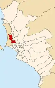 Location of San Martín de Porres in Lima | |
| Country | |
| Region | Lima |
| Province | Lima |
| Created | May 22, 1950 |
| Capital | Barrio Obrero Industrial |
| Government | |
| • Mayor | Hernán Sifuentes (2023-2026) |
| Area | |
| • Total | 41.5 km2 (16.0 sq mi) |
| 36.91 km² (not including disputed areas) | |
| Elevation | 123 m (404 ft) |
| Population (2023)[1] | |
| • Total | 782,075 |
| Time zone | UTC-5 (PET) |
| UBIGEO | 150135 |
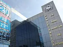
| Website | mdsmp.gob.pe |

History
Since 1945, continuous invasions of territory in what was then part of the Carabayllo District, ended up in the creation of the Distrito Obrero Industrial 27 de Octubre on May 22, 1950, which is still celebrated as the district's anniversary. The district was composed of the following haciendas: Chuquitanta, Pro, Naranjal, Infantas, Santa Rosa, Garagay Alto, G. Bajo, Chavarría, Mulería, Aliaga, Condevilla, San José, Palao, Huerta Sol, Oquendo, San Agustín and Marquez. The last three became part of Callao province, in 1956.
In 1962, after the canonization of St. Martin de Porras, the name of the district was changed to its current name. Although historians have shown that the saint's actual last name was Porras, the district has retained the original spelling.
The district of Los Olivos was created in 1989, stripping some of San Martín de Porres' northeastern territory.
Borderline conflicts
Due to the territorial reduction due to the creation of the Los Olivos district, two conflict zones arise, one with the Independencia District and the other with the Comas District.[2] These districts argue that, when Los Olivos was created, part of the old industrial zone in San Martín de Porres would correspond to them to be annexed, however, according to San Martín de Porres, the law for the creation of a new district could not detail the transfer of territory to others not involved and because it was not an express request of the residents. It also highlights that the laws creating Comas (Law No. 13757) and Independencia (Law No. 14965, Law No. 16012) mark their limits on the Old Pan-American North (today Avenida Túpac Amaru).The conflict remains and both zones are not yet defined by the Metropolitan Planning Institute, the Metropolitan Municipality of Lima or the Congress of the Republic.[3]
Conflict with Independencia district
The first zone in territorial conflict is with the district of Independencia, in a quadrangular shape of 2.40 square kilometers. It is delimited by Av. Panamericana Norte, Av. Naranjal, Avenida Tupac Amaru and Avenida Tomas Valle, and contains the urbanizations Naranjal, Industrial, Mesa Redonda, Mulería, Industrial El Naranjal, Industria Panamericana Norte and the Residential Naranjal Housing Association. The conflict also affects the municipal tax system since the large shopping centers pay taxes to Independencia, however the urbanizations and small and medium businesses pay taxes in San Martín de Porres.[4]

Conflict with Comas district
The second zone in territorial conflict is with the district of Comas, in a triangular shape of 1.28 square kilometers. It is delimited by Av. San Bernardo, Av. Panamericana Norte and Avenida Gerardo Unger, up to the next bank of the Chillón River, and contains the urbanizations Santa Luisa, Santa Rosa de Infantas, Pro Industrial IV and IX Sector III Stage; the Municipal Human Settlement No. 02; and the housing associations José de San Martín, José Carlos Mariátegui and San Miguel. The conflict also affects the municipal tax system since medium-sized and small businesses are taxed in both municipalities, however urbanizations are taxed in San Martín de Porres.


Geography
The district has a total land area of 41.5 km² (area not including disputed areas would be 36.91 km²[5]

Authorities
Mayors
- 2023-2026: Hernán Tomás Sifuentes Barca (PP)
- 2019-2022: Julio Abraham Chávez Chiong (AP)
- 2015-2018: Adolfo Israel Mattos Piaggio (SU)
- 2011-2014: Freddy Ternero † (PPC)
- 2007-2010: Freddy Ternero † (SP)
- 2003-2006: Lucio Campos Huayta (UN)
- 1999-2002: Gladys Ugaz de Vera (SP)
- 1996-1998: Jaime Kanashiro Ywamoto (C90-NM)
- 1993-1995: José Arcenio Rubio Valqui (OBRAS)
- 1990-1992: Marcelino Morales Scandon (FREDEMO-AP)
- 1987-1989: José Isaac Miranda Valladares (IU)
- 1984-1986: José Isaac Miranda Valladares (IU)
- 1981-1983: Willy Fernández Melo (IU)
- 1967-1969: Enrique León Velarde Gamarra † (AP-DC)
- 1964-1966: Víctor Reyes Ramos (APRA-UNO)
Urban landmarks
There are shopping centers and institutions in the district:
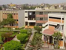
- Cayetano Heredia University
- Cayetano Heredia National Hospital
- National Institute of Mental Health "Honorio Delgado - Hideyo Noguchi"
- FIORI Comercial Centre
- Real Plaza Pro
- Plaza Center Rex
Avenues
- Carretera Panamericana Norte (PE-1N Pan American highway)
- Avenida Caquetá
- Avenida Zarumilla (PE-1N)
- Avenida Eduardo de Habich
- Avenida Túpac Amaru (PE-20A)
- Avenida Canta Callao (PE-20)
- Avenida Naranjal
- Avenida Tantamayo
- Avenida Paramonga
- Avenida Carlos Izaguirre
- Avenida Los Alisos
- Avenida Próceres
- Avenida José Granda
- Avenida Bocanegra
- Avenida Angélica Gamarra
- Avenida Tomás Valle
- Avenida Universitaria
- Avenida Germán Aguirre
- Avenida José Granda
- Avenida Lima
- Avenida Pacasmayo
- Avenida Perú
- Avenida Los Próceres
- Avenida 12 de Octubre
- Avenida Salaverry
- Avenida Quilca
Neighborhoods
- Urb Barrio Obrero
- Urb Caquetá
- Urb Miguel Grau
- Urb Zarumilla
- Urb Ingenieria
- Urb Palao
- Urb Los Jardines
- Urb Fiori
- Urb Perú
- Urb Condevilla Señor
- Urb San Germán
- Urb Antares
- Urb Los Libertadores
- Urb El Pacífico
- Urb Garagay
- Urb Valdivieso
Disputed areas (some with neighborhood recognition)
- Urb. El Naranjal (In dispute with Independencia)
- Urb. Mesa Redonda (In dispute with Independencia)
- Urb. Industrial Panamericana (In dispute with Independencia)
- Urb. Infantas (In dispute with Comas)
- Urb. Santa Luisa (In dispute with Comas)
- Urb Industrial Pro (In dispute with Comas)
Pre-Hispanic Buildings (Huacas)
- Huaca El Paraiso
- Huaca Garagay
- Huaca Palao

.jpg.webp)
See also
References
- "Estadística Poblacional - Ministerio de Salud del Perú".
- Yensen, Erika. "Borderline conflict between Independencia, San Martin de Porres, Comas districts" (PDF).
- "Opportunity to resolve the conflict". Canal N.
- "Disputed area between San martin de porres and Independencia". El Comercio.
- Mayor of San Martin de Porres. "Details of San Martin de Porres".
External links
- (in Spanish) Municipalidad Distrital de San Martín de Porres - San Martín de Porres district council official website
- (in Spanish) Universidad Cayetano Heredia