Sapphire Ridge, Montana
Sapphire Ridge is a census-designated place (CDP) in Judith Basin County, Montana, United States. The community is more commonly known as Sapphire Village.[3][4] It is in the southern part of the county, on the west side of the valley of the Judith River, a northeast-flowing tributary of the Missouri River.
Sapphire Ridge, Montana | |
|---|---|
 Sapphire Ridge  Sapphire Ridge | |
| Coordinates: 46°53′12″N 110°15′9″W | |
| Country | United States |
| State | Montana |
| County | Judith Basin |
| Area | |
| • Total | 0.54 sq mi (1.40 km2) |
| • Land | 0.54 sq mi (1.40 km2) |
| • Water | 0.00 sq mi (0.00 km2) |
| Elevation | 4,894 ft (1,492 m) |
| Population (2020) | |
| • Total | 26 |
| • Density | 48.15/sq mi (18.58/km2) |
| Time zone | UTC-7 (Mountain (MST)) |
| • Summer (DST) | UTC-6 (MDT) |
| ZIP Code | 59452 (Hobson) |
| Area code | 406 |
| FIPS code | 30-66317 |
| GNIS feature ID | 2806632[2] |
Pigeye Road is the main route out of the community, leading northeast 10 miles (16 km) down the Judith River valley to Utica. To the southwest the road leads into the Little Belt Mountains and Lewis and Clark National Forest.
Sapphire Ridge was first listed as a CDP prior to the 2020 census.[2]
References
- "ArcGIS REST Services Directory". United States Census Bureau. Retrieved September 5, 2022.
- "Sapphire Ridge Census Designated Place". Geographic Names Information System. United States Geological Survey, United States Department of the Interior.
- "Sapphire Village, Montana". RussellCountry.com. Retrieved June 10, 2021.
- "Sapphire Village". Geographic Names Information System. United States Geological Survey, United States Department of the Interior.
- "Census of Population and Housing". Census.gov. Retrieved June 4, 2016.
Municipalities and communities of Judith Basin County, Montana, United States | ||
|---|---|---|
| City | 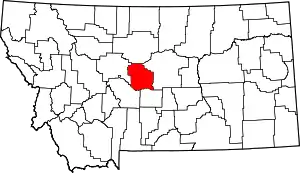 Judith Basin County map | |
| Town | ||
| CDPs | ||
| Other community | ||
| Ghost town | ||
This article is issued from Wikipedia. The text is licensed under Creative Commons - Attribution - Sharealike. Additional terms may apply for the media files.