Seraikela Kharsawan district
Seraikela-Kharsawan district or Saraikella and Kharaswan district[1] is one of the twenty-four districts of Jharkhand state in eastern India. Seraikela town is the district headquarters of Saraikela Kharsawan district . The district is well known for Seraikela Chhau, one of the three distinctive styles of the chhau dance. This district was carved out from West Singhbhum district in 2001. The district was formed from the Odia princely states of Seraikela and Kharaswan, after the independence of India.
Seraikela-Kharsawan district | |
|---|---|
 | |
.svg.png.webp) Location of Seraikela-Kharsawan district in Jharkhand | |
| Coordinates (Seraikela): 22.7°N 85.25°E | |
| Country | |
| State | |
| Division | Kolhan division |
| Headquarter | Seraikela |
| Government | |
| • Member of Parliament | Arjun Munda (BJP) Sanjay Seth (BJP) Geeta Kora (INC) |
| • Collector & District Magistrate | Ravi Shankar Shukla, IAS |
| • Superintendent of Police | Bimal Kumar, IPS |
| Area | |
| • Total | 2,657 km2 (1,026 sq mi) |
| Population (2011) | |
| • Total | 1,065,056 |
| • Density | 400/km2 (1,000/sq mi) |
| • Urban | 16.30% |
| Demographics | |
| • Literacy | 68.85 % |
| • Sex ratio | 958 |
| Time zone | UTC+05:30 (IST) |
| Vehicle registration | JH-22 |
| Average annual precipitation | 1350 mm |
| Lok Sabha constituencies | 3 constituency:
|
| Legislative Assembly Constituency | 3 constituency: |
| Website | seraikela |
History
Ruling dynasty
Members of the erstwhile royal family of Seraikella, the Singh Deo family (patrons of the Chhau dance), divide their time between The Palace, Seraikella; a 300-year-old heritage palace and historical landmark and their residences in Odisha, West Bengal and abroad. The last ruler of the Seraikella princely state was HH Raja Aditya Pratap Singh Deo (grandson of HH Maharaja Udit Narayan Singh Deo) and notables of the era include his sons Tikayet Sahib Nrupendra Narayan Singh Deo, HH Maharaja Sir Rajendra Narayan Singh Deo (given in adoption to Patna-Bolangir state, former Chief Minister of Odisha), Patayet Sahib Maharaj kumar Bhoopendra Narayan Singh Deo (leading regional politician who supported the popular tribal anti-merger movement with Bihar) and Rajkumar Sudhendra Narayan Singh Deo (Param-Guru of Chhau, a Padma Shri awardee).
The Singh Deo royal family remains active in public life (political, cultural and religious) and act as guardians to the Ma Paudi temple located within the royal residence, host the annual Chau festival at the Seraikella Royal Palace and retain a hold on the region's real-estate and business. Despite their loss of formal title and privileges, they enjoy public support in the area (comprising the former Seraikella state). Notable members of the royal family who remain active in the public eye include Rajkumar Pratap Aditya Singh Deo, Rajkumar Juga Bhanu Singh Deo, Maharajkumar Jairaj Singh Deo and Rajkumar Rajvikram Singh Deo. The District of Seraikela and Kharsawan was formed on 1 April 2001 after being separated from West Singhbhum district.
Recent events
The district is currently a part of the Red Corridor.[2]
Geography
The district is situated between 22°29'26" and 23°09'34" north latitudes and 85°30'14" and 86°15'24" east longitudes.
Rivers and lakes
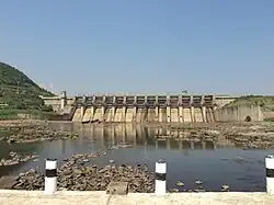
Several rivers flow across Seraikela Kharsawan district. Among these Subarnarekha, Kharkai, Korkori are the important ones. Chandil dam is one of the popular and famous waterbodies of the district. It is located near the Chandil town.[3]
Economy
In 2006 the Ministry of Panchayati Raj named Seraikela Kharsawan one of the country's 250 most backward districts (out of a total of 640).[4] It is one of the 21 districts in Jharkhand currently receiving funds from the Backward Regions Grant Fund Programme (BRGF).[4]
Politics
| District | No. | Constituency | Name | Party | Alliance | Remarks | ||
|---|---|---|---|---|---|---|---|---|
| Seraikela Kharsawan | 50 | Ichaghar | Sabita Mahato | Jharkhand Mukti Morcha | UPA | |||
| 51 | Seraikella | Champai Soren | Jharkhand Mukti Morcha | UPA | Cabinet Minister | |||
| Seraikela Kharsawan | 57 | Kharsawan | Dasrath Gagrai | Jharkhand Mukti Morcha | UPA | |||
Administration
Blocks/Mandals
Seraikela Kharsawan district consists of 09 Blocks. The following are the list of the Blocks in Seraikela Kharsawan district:
1 Seraikela, 2 Kharsawan, 3 Gamharia, 4 Kuchai, 5 Ichagarh, 6 Nimdih, 7 Chandil, 8 Rajnagar, 9 Kukru
Divisions
There are three Vidhan Sabha constituencies in this district: Ichagarh, Seraikela and Kharsawan. These are parts of Ranchi, Singhbhum and Khunti Lok Sabha constituencies respectively.
Demographics
|
| ||||||||||||||||||||||||||||||||||||||||||
| source:[5] | |||||||||||||||||||||||||||||||||||||||||||
According to the 2011 census Seraikela Kharsawan district has a population of 1,065,056,[7] roughly equal to the nation of Cyprus[8] or the US state of Rhode Island.[9] This gives it a ranking of 428th in India (out of a total of 640).[7] The district has a population density of 401 inhabitants per square kilometre (1,040/sq mi) .[7] Its population growth rate over the decade 2001-2011 was 25.28%.[7] Saraikela Kharsawan has a sex ratio of 958 females for every 1000 males,[7] and a literacy rate of 68.85%. 24.29% of the population lives in urban areas. Scheduled Castes and Scheduled Tribes make up 5.28% and 35.18% of the population respectively.[7]
At the time of the 2011 Census of India, 44.01% of the population in the district spoke Bengali as their first Language , 15.62% Santali, 9.65% Ho, 9.48% Odia, 6.98% Hindi, 4.76% Mundari, 2.83% Urdu, 2.7% Bhojpuri and 1.05% Maithili.[10]
In rural areas, Bengali is the main language. Various tribal languages are spoken throughout the district, and Odia is the main language in the west of the district.
References
- Dr. Anil Mohapatra. "The Unfinished Task of Orissa Formation" (PDF). Orissa Review. Archived from the original (pdf) on 2016-09-19.
- "83 districts under the Security Related Expenditure Scheme". IntelliBriefs. 2009-12-11. Retrieved 2011-09-17.
- "District at a Glance".
- Ministry of Panchayati Raj (September 8, 2009). "A Note on the Backward Regions Grant Fund Programme" (PDF). National Institute of Rural Development. Archived from the original (PDF) on April 5, 2012. Retrieved September 27, 2011.
- "Table A-02 Decadal Variation in Population Since 1901: Jharkhand" (PDF). census.gov.in. Registrar General and Census Commissioner of India.
- "Table C-15 Population by Religion - Jharkhand". censusindia.gov.in. Registrar General and Census Commissioner of India. 2011.
- "District Census Handbook: Seraikela Kharsawan" (PDF). censusindia.gov.in. Registrar General and Census Commissioner of India. 2011.
- US Directorate of Intelligence. "Country Comparison:Population". Archived from the original on June 13, 2007. Retrieved 2011-10-01.
Cyprus 1,120,489 July 2011 est.
- "2010 Resident Population Data". U. S. Census Bureau. Retrieved 2011-09-30.
Rhode Island 1,052,567
- "Table C-16 Population by Mother Tongue: Jharkhand". Census of India. Registrar General and Census Commissioner of India.
External links
Places adjacent to Seraikela Kharsawan district | ||||||||||||||||
|---|---|---|---|---|---|---|---|---|---|---|---|---|---|---|---|---|
| ||||||||||||||||