Savitaipale
Savitaipale (Finnish: [ˈsɑʋiˌtɑi̯pɑle]; literally translated the "clay passage") is a municipality of Finland. It is located in the South Karelia region. The municipality has a population of 3,228 (19 September 2023)[2] and covers an area of 690.56 square kilometres (266.63 sq mi) of which 150.81 km2 (58.23 sq mi) is water.[1] The population density is 5.98 inhabitants per square kilometre (15.5/sq mi).

Savitaipale | |
|---|---|
Municipality | |
| Savitaipaleen kunta Savitaipale kommun | |
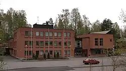 Savitaipale town hall | |
 Coat of arms | |
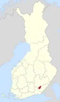 Location of Savitaipale in Finland | |
| Coordinates: 61°12′N 027°41′E | |
| Country | |
| Region | South Karelia |
| Sub-region | Lappeenranta sub-region |
| Charter | 1639 |
| Municipality | 1867 |
| Government | |
| • Municipal manager | Johanna Mäkelä |
| Area (2018-01-01)[1] | |
| • Total | 690.56 km2 (266.63 sq mi) |
| • Land | 539.74 km2 (208.39 sq mi) |
| • Water | 150.81 km2 (58.23 sq mi) |
| • Rank | 160th largest in Finland |
| Population (2023-09-19)[2] | |
| • Total | 3,228 |
| • Rank | 210th largest in Finland |
| • Density | 5.98/km2 (15.5/sq mi) |
| Population by native language | |
| • Finnish | 98% (official) |
| • Swedish | 0.3% |
| • Others | 1.7% |
| Population by age | |
| • 0 to 14 | 10.9% |
| • 15 to 64 | 49.8% |
| • 65 or older | 39.2% |
| Time zone | UTC+02:00 (EET) |
| • Summer (DST) | UTC+03:00 (EEST) |
| Website | www.savitaipale.fi |

The bastionné line of the coat of arms refers to Savitaipale's position as a border keeper in the period between the Treaty of Åbo concluded in 1743 and the border review carried out in 1812. The plough in the coat of arms refers to the local agriculture in the region. The coat of arms was designed by Viljo Savikurki, and the Savitaipale municipal council approved it on January 2, 1953. The Ministry of the Interior approved the coat of arms for use on March 3 of the same year.[5][6]
People
- Jonni Myyrä (1892–1955)
- Päivi Tikkanen (born 1960)
- Taneli Tikka (born 1978)
See also
- "Savitaipaleen polkka" — also known as "Ievan polkka"
References
- "Area of Finnish Municipalities 1.1.2018" (PDF). National Land Survey of Finland. Retrieved 30 January 2018.
- "Finland's preliminary population figure was 5,587,841 at the end of August 2023". StatFin. Statistics Finland. Retrieved 30 September 2023.
- "Demographic Structure by area as of 31 December 2022". Statistics Finland's PX-Web databases. Statistics Finland. Retrieved 6 September 2023.
- "Population according to age (1-year) and sex by area and the regional division of each statistical reference year, 2003–2020". StatFin. Statistics Finland. Retrieved 2 May 2021.
- Suomen kunnallisvaakunat (in Finnish). Suomen Kunnallisliitto. 1982. p. 161. ISBN 951-773-085-3.
- "Sisäasiainministeriön vahvistamat kaupunkien, kauppaloiden ja kuntien vaakunat I:13 Savitaipale" (in Finnish). Kansallisarkiston digitaaliarkisto. Retrieved July 26, 2022.
External links
![]() Media related to Savitaipale at Wikimedia Commons
Media related to Savitaipale at Wikimedia Commons
- Municipality of Savitaipale – Official website
- goSaimaa.com – travel information
Places adjacent to Savitaipale | ||||||||||||||||
|---|---|---|---|---|---|---|---|---|---|---|---|---|---|---|---|---|
| ||||||||||||||||
| Municipalities |  | |
|---|---|---|
| Former municipalities | ||