Pennsylvania Route 23
Pennsylvania Route 23 (PA 23) is an 81.14-mile-long (130.58 km) state highway in southeastern Pennsylvania. The route begins at PA 441 in Marietta and heads east to U.S. Route 1 (US 1) at City Avenue on the border of Lower Merion Township and Philadelphia. PA 23 begins at Marietta in Lancaster County and continues east to Lancaster, where it passes through the city on a one-way pair of streets and intersects US 222 and US 30.
Pennsylvania Route 23 | ||||
|---|---|---|---|---|
| Route information | ||||
| Maintained by PennDOT, City of Lancaster, Upper Merion Township, and Lower Merion Township | ||||
| Length | 81.144 mi[1] (130.589 km) | |||
| Existed | 1928–present | |||
| Tourist routes | Conestoga Ridge Byway | |||
| Major junctions | ||||
| West end | ||||
| East end | ||||
| Location | ||||
| Country | United States | |||
| State | Pennsylvania | |||
| Counties | Lancaster, Berks, Chester, Montgomery | |||
| Highway system | ||||
| ||||
East of Lancaster, the route runs through agricultural areas in Pennsylvania Dutch Country, serving Leola, New Holland, and Blue Ball, the latter location where it crosses US 322. PA 23 passes through the southern tip of Berks County and serves Morgantown, where a ramp provides access to Interstate 176 (I-176). The route runs through northern Chester County and serves Elverson, Bucktown, Phoenixville, and Valley Forge.
PA 23 continues into Montgomery County and intersects US 422 in King of Prussia and US 202 in Bridgeport. The route follows the Schuylkill River to West Conshohocken, where it has access to I-76 and I-476, before it continues southeast through Lower Merion Township to US 1, which there is running on the border between Montgomery County and Philadelphia. The portion of PA 23 between Blue Ball and west of Morgantown is designated the Conestoga Ridge Byway, a Pennsylvania Scenic Byway.
PA 23 was first designated in 1927 between US 230 in Lancaster and City Avenue on the Lower Merion Township/Philadelphia border. The route was extended east to US 30 (Girard Avenue) in West Philadelphia via Conshohocken Avenue and Belmont Avenue in the 1930s.
PA 23 was rerouted to use Gulph Road through Valley Forge Park by 1945, with PA 23 Truck designated to bypass the route to the north and east by 1950. PA 23 Alternate (PA 23 Alt.) was designated as an alternate alignment in Lower Merion Township in 1937. PA 23 was moved to its current alignment between Valley Forge and Bala Cynwyd by 1967, replacing parts of PA 363 between Valley Forge and Port Kennedy and PA 320 between Bridgeport and West Conshohocken. The alternate and truck routes were also decommissioned at this time.
The route was extended west from Lancaster to Marietta by 1970, replacing a part of PA 340; the route was also moved onto a one-way pair in Lancaster. The eastern terminus was moved to its current location in the 1980s. PA 23 was rerouted to its current alignment in the eastern part of Lancaster in 1992, bypassing New Holland Avenue.
A PA 23 freeway was proposed east of Lancaster in the 1960s; parts of the road were built before construction stopped. The road was turned over to farmers and is known as the "Goat Path". A two-lane bypass of PA 23 east of Lancaster was later proposed before being shelved in 2010. A freeway between US 422 and US 202 in Upper Merion Township called the Schuylkill Parkway was planned in the 1960s; a small stub in Bridgeport was built in 1972 before funding issues halted the project.
Route description
Lancaster County
PA 23 begins at an intersection with PA 441 on the eastern edge of the borough of Marietta in Lancaster County, heading east on two-lane undivided Marietta Avenue into East Donegal Township. The road runs through a mix of farmland and trees with some residences, crossing Donegal Creek before heading across Chiques Creek into West Hempfield Township. The route continues through rural land with some housing developments as Marietta Pike, passing through the community of Silver Spring. PA 23 runs through farm fields with some residential and commercial development and crosses into East Hempfield Township at the Stony Battery Road intersection in the community of Oyster Point. The road continues through development with some farmland, coming to bridges over the US 30 freeway without an interchange and Norfolk Southern's Columbia Secondary railroad line. The route passes homes in the community of Rohrerstown and reaches an intersection with PA 741. PA 23 runs through wooded residential areas and enters Lancaster Township upon crossing Little Conestoga Creek. The route becomes Marietta Avenue, running through the community of School Lane Hills and curving to the southeast. The road passes to the north of Wheatland, the former home of 15th President James Buchanan, before it enters the city of Lancaster and becomes city-maintained.[2][3]
Upon entering Lancaster, PA 23 intersects the westbound direction of PA 462 at Race Avenue. Here, the route splits into a one-way pair, with the eastbound direction of PA 23 continuing along two-way Marietta Avenue and the westbound direction of PA 23 becoming concurrent with westbound PA 462 on one-way West Walnut Street, carrying two lanes. Two blocks later, near the former UPMC Pinnacle Lancaster hospital, eastbound PA 23 splits from Marietta Avenue onto one-way eastbound West Chestnut Street, with two lanes. The route follows West Chestnut Street eastbound and West Walnut Street westbound, continuing concurrent with PA 462 westbound, passing through residential areas of the city. Eastbound PA 462 is located two blocks south of eastbound PA 23 along King Street. The route heads into the commercial downtown of Lancaster, where it intersects one-way southbound US 222/PA 272 at North Prince Street. A short distance later, PA 23 crosses one-way northbound PA 72 at North Queen Street. Past this intersection, the route becomes East Chestnut Street eastbound and East Walnut Street westbound, intersecting one-way northbound US 222/PA 272 at North Lime Street at the east end of downtown. Following this, PA 23 passes more homes and industrial establishments in the eastern part of the city. At North Broad Street, westbound PA 462 splits from westbound PA 23, and the two directions of PA 23 merge a short distance later onto four-lane divided East Walnut Street, which is state-maintained. The route curves northeast through wooded areas with some nearby development, passing through a corner of Manheim Township before crossing under the Conestoga Creek Viaduct that carries Amtrak's Keystone Corridor railroad line over the route and the Conestoga River immediately to the east. The road continues north into Lancaster again before it turns northeast into Manheim Township and crosses the Conestoga River back into Lancaster. PA 23 comes to an interchange with the US 30 freeway, onto which it turns northwest for a brief wrong-way concurrency, with a dead end stub heading northeast.[2][3]
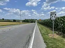
PA 23 follows US 30 along a four-lane freeway, in said wrong-way concurrency, and crosses the Conestoga River into Manheim Township. After the river, PA 23 splits from US 30 at a diamond interchange and heads northeast onto New Holland Pike, a three-lane road with a center left-turn lane. The route passes through wooded residential areas to the west of the Lancaster Country Club in the community of Eden. The road narrows to two lanes and curves east to cross the Conestoga River into East Lampeter Township, passing through the community of Holland Heights.[2][3] At this point, the route enters the Pennsylvania Dutch Country of eastern Lancaster County, which is home to many Amish farms.[4][5] PA 23 continues into Upper Leacock Township and passes through a mix of farmland and residential and commercial development, passing north of the Lancaster County Christian School and running through the community of Geist and Leacock, where it becomes West Main Street. The route reaches the community of Leola, where PA 772 joins for a short concurrency before it splits to the southeast. The road becomes East Main Street and is lined with more homes and businesses with nearby farmland as it continues east through the community of Bareville. PA 23 becomes the border between West Earl Township to the north and Upper Leacock Township to the south before it enters Earl Township in the community of Groffdale.[2][3]
The road becomes West Main Street and curves northeast past residential and commercial development, crossing into the borough of New Holland. The route becomes lined with homes and passes through the commercial downtown, where it becomes East Main Street. PA 23 runs past more residences before entering commercial areas, passing to the south of Garden Spot High School and crossing back into Earl Township. The route enters East Earl Township and runs past a mix of farmland, homes, and businesses as Main Street, crossing US 322 in the community of Blue Ball. PA 23 continues east past more development and intersects PA 897, with that route joining PA 23 for a short concurrency before it heads south. Past this, PA 23 enters agricultural areas and intersects the southern terminus of PA 625. The road runs through more farmland, passing through the residential community of Goodville before it enters Caernarvon Township. The route crosses the Conestoga River and runs through Churchtown. The road curves north-northeast through more rural areas, passing north of Conestoga Christian School before coming to an intersection with PA 10. Here, PA 10 becomes concurrent with PA 23 on a three-lane road with a center left-turn lane, heading into commercial areas.[2][3] The section of PA 23 in Lancaster County between US 322 and PA 10 is designated as the Conestoga Ridge Byway, a Pennsylvania Scenic Byway.[6]
Berks and Chester counties
The road crosses into Caernarvon Township in Berks County and intersects a ramp that heads north to provide access to northbound I-176 and from southbound I-176. The two routes continue into the community of Morgantown as a two-lane road and pass homes. PA 10 splits from PA 23 by turning north onto Morgantown Road, and PA 23 continues east past more residences and some businesses. The route comes to a bridge over the Pennsylvania Turnpike (I-76) and heads south of Morgantown Airport before passing through farmland with some commercial development, coming to a junction with the western terminus of PA 401.[2][7]
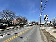
A short distance past the PA 401 intersection, PA 23 enters the borough of Elverson in Chester County as West Main Street, briefly gaining a median before passing homes and intersecting the northern terminus of PA 82. Past this intersection, the name of the roadway becomes East Main Street. The route briefly gains a median again before it leaves Elverson for West Nantmeal Township, where it becomes Ridge Road and heads into a mix of farmland and woodland with some homes. The road soon enters Warwick Township, where it reaches a junction with PA 345 in the community of Warwick. PA 23 continues through wooded areas with some fields and residences, passing to the south of the community of Saint Peters, where it crosses French Creek, and running to the north of Warwick County Park. The route crosses into South Coventry Township and passes through the community of Coventryville before it intersects PA 100 in Bucktown. The road passes south of Owen J. Roberts High School before it crosses into East Vincent Township and continues through a mix of fields, woods, and homes, soon entering East Coventry Township. PA 23 curves southeast and crosses back into East Vincent Township and runs through more rural land with some residences, passing to the north of a golf course. The route enters East Pikeland Township and passes near residential neighborhoods before it intersects the eastern terminus of PA 724.[2][8]
At this point, PA 23 turns south onto Schuylkill Road, passing businesses and curving to the southeast. The route becomes the border between the borough of Phoenixville to the northeast and Schuylkill Township to the southwest and crosses French Creek before passing more businesses and intersecting PA 113. At this point, PA 113 turns southeast to form a concurrency with PA 23 on Nutt Road, a three-lane road with a center left-turn lane that fully enters Phoenixville. The road passes businesses and crosses under an abandoned railroad line, at which point it continues through residential areas. PA 113 splits from PA 23 by heading northeast on Bridge Street, while PA 23 continues southeast on two-lane Nutt Road. The route runs through residential areas with some businesses and passes to the northeast of Phoenixville Hospital before crossing PA 29. The road passes more suburban development and crosses into Schuylkill Township, where it becomes Valley Forge Road and curves to the east. PA 23 crosses Pickering Creek at the dam forming Pickering Creek Reservoir to the south and turns southeast through wooded areas of residential development.[2][8] The route reaches the community of Valley Forge, where it curves east and enters Valley Forge National Historical Park, the site where General George Washington and the Continental Army made an important winter encampment during the American Revolutionary War.[2][8][9]
Montgomery County
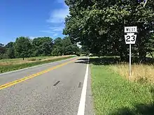
Upon crossing Valley Creek, PA 23 enters Upper Merion Township in Montgomery County and intersects the northern terminus of PA 252. The route becomes Valley Forge Park Road and intersects Gulph Road to the south of Washington's Headquarters. The road continues east through fields and woods within Valley Forge National Historical Park, passing near the Friedrich Wilhelm von Steuben statue and Washington Memorial Chapel. PA 23 curves south and intersects North Gulph Road near the park's Visitor Center, at which point the route turns east onto four-lane divided Valley Forge Road and immediately comes to an interchange with the US 422 freeway. The route passes between residential high-rise buildings to the north and business parks to the south, narrowing into a two-lane undivided road and heading northeast. The road turns southeast and crosses Trout Creek, running near more business parks and widening back to a four-lane divided highway. PA 23 turns northeast onto four-lane, undivided, township-maintained Geerdes Boulevard briefly, with Allendale Road turning southeast, before heading east on two-lane, undivided, state-maintained Valley Forge Road. The route winds east through suburban residential neighborhoods in King of Prussia, intersecting Henderson Road. The road passes near more homes before reaching a bridge over the unused Schuylkill Parkway freeway stub. PA 23 passes under the William F. Dannehower Memorial Bridge, which carries southbound US 202 over the route and the Schuylkill River to the north, and curves south into the borough of Bridgeport. Here, the route comes to an intersection with the Schuylkill Parkway, which provides a connection to the route from southbound US 202, and turns east onto a four-lane divided highway, passing to the south of industrial development and crossing under SEPTA's Norristown High Speed Line. PA 23 intersects northbound US 202 at Dekalb Street in the commercial center of Bridgeport and continues east past urban homes and businesses on two-lane undivided West 4th Street. The route becomes East 4th Street and passes near more neighborhoods and some industrial development, curving southeast.[2][10]
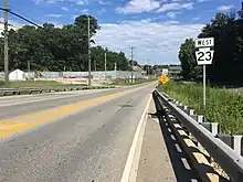
PA 23 turns east onto Coates Street and forms the border between Bridgeport to the north and Upper Merion Township to the south. The route curves southeast into Upper Merion Township and becomes Schuylkill River Road, running between homes to the southwest and Norfolk Southern's Harrisburg Line and the Schuylkill River parallel to the northeast. The road passes under the Schuylkill River Bridge, which carries the Pennsylvania Turnpike (I-276), and Norfolk Southern's Dale Secondary, continuing south through a mix of woodland and industrial areas further west of the river and the railroad tracks and passing to the east of a quarry. In Swedeland, PA 23 gains a second westbound lane and intersects the northern terminus of PA 320. The road curves southeast past more industry, narrowing to two lanes and crossing an Upper Merion and Plymouth Railroad spur at-grade before entering the borough of West Conshohocken. Here, the route becomes Front Street and runs closely parallel to the Harrisburg Line and the Schuylkill River again, passing under the Pearl Harbor Memorial Bridge that carries I-476 over the river. PA 23 heads through PECO's West Conshohocken Gas Operations Center before it crosses Gulph Creek. Following this, the route runs past homes and intersects Fayette Street/Matsonford Road near several high-rise office buildings. Fayette Street heads northeast across the river on the Fayette Street Bridge to the borough of Conshohocken and Matsonford Road heads southwest to provide access to the Schuylkill Expressway (I-76) and I-476.[2][10]
Past this, the route becomes Crawford Avenue and curves to the east past commercial development. The road turns south and becomes Conshohocken State Road, passing under I-76. PA 23 enters Lower Merion Township and curves southeast, passing through forested areas of residential development. At the Spring Mill Road intersection, the route becomes township-maintained and winds its way southeast. The road heads through the community of Gladwyne, where it passes homes and a few businesses, before it crosses Mill Creek and makes a turn to the north and a curve southeast in forested areas. At Hollow Road, PA 23 becomes state-maintained again and winds southeast through more wooded residential areas. The route comes to Bala Cynwyd, where it intersects Montgomery Avenue and Bala Avenue and turns east to follow four-lane, township-maintained Conshohocken State Road. PA 23 passes over SEPTA's Cynwyd Line at its terminus at the Cynwyd station and turns southeast past more homes. The route enters commercial areas and reaches its eastern terminus at US 1 (City Avenue) on the border of Lower Merion Township in Montgomery County and the city of Philadelphia in Philadelphia County, at which point Conshohocken Avenue continues into Philadelphia.[2][10]
History
Designation
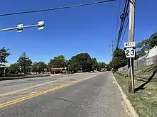
The road between Marietta and Lancaster was chartered as a private turnpike called the Lancaster, New Haven, and Waterford Turnpike in 1805, later being known as the Lancaster and Marietta Turnpike. What would become PA 23 between Lancaster and New Holland was chartered as the New Holland and Lancaster Turnpike on March 20, 1810. The Morgantown, Churchtown, and Blue Ball Turnpike was chartered on February 25, 1814. This turnpike, which was built along the Horse-Shoe Road and ran between the Downingtown and Harrisburg Turnpike at Blue Ball and Little Conestoga in Morgantown, was finished in 1819.[11]
When Pennsylvania first legislated routes in 1911, what would become PA 23 was designated as Legislative Route 244 between Leacock and Morgantown and Legislative Route 201 between Phoenixville and King of Prussia.[12] In 1927, PA 23 was designated to run from US 230/PA 41/PA 72 (Prince Street) in Lancaster east to City Avenue on the border of Philadelphia. The route followed Walnut Street and New Holland Avenue before continuing along its current alignment between Lancaster and Port Kennedy, where it ran southeast along Gulph Road and Old Gulph Road before turning east along Spring Mill Road and southeast along Morris Avenue, Williamson Road, Old Gulph Road, Mill Creek Road, Conshohocken State Road, and Bala Avenue.[13][14][15][16] When first designated, the entire length of the route was paved.[14] The route between Marietta and Lancaster was an unnumbered road that was paved by 1930.[14][15] The present route between Bridgeport and Swedeland was designated as part of PA 123 in 1928.[14]
_from_the_overpass_for_Interstate_476_(Mid-County_Expressway-%22Blue_Route%22)_in_West_Conshohocken%252C_Montgomery_County%252C_Pennsylvania.jpg.webp)
In the 1930s, PA 23 was extended east to US 30 (Girard Avenue) in West Philadelphia, following Conshohocken Avenue and Belmont Avenue.[17] By 1940, the road between Marietta and Lancaster became part of an extended PA 340.[18] By 1945, PA 23 was rerouted to pass through Valley Forge Park along Gulph Road, with an extended PA 363 replacing the route on Valley Forge Road and PA 652 replacing the designation between PA 363 and Gulph Road.[19] By 1950, PA 23 Truck was designated as a truck bypass of the section along Gulph Road through Valley Forge Park, running concurrent with PA 363 on Valley Forge Road before turning south along former PA 652. In addition, PA 23 Alt. was designated as an alternate alignment in Lower Merion Township following Montgomery Avenue.[20] The current alignment between US 202 in Bridgeport and Spring Mill Road in Lower Merion Township became a northern extension of PA 320 by 1960.[21]
By 1967, PA 23 was moved to its current alignment between Valley Forge and Bala Cynwyd. The route replaced PA 363 and PA 23 Truck along Valley Forge Road through Valley Forge Park and replaced PA 320 between Bridgeport and Spring Mill Road.[22] By 1970, PA 23 was extended west from US 222/PA 72 in Lancaster to PA 441 in Marietta, replacing PA 340.[23] In Lancaster, the route was moved to a one-way pair following Chestnut Street eastbound and Walnut Street westbound between College Avenue and Plum Street.[24] In the 1970s, the west end of the one-way pair in Lancaster was shifted to Race Street while westbound PA 462 was designated concurrent with westbound PA 23 on Walnut Street, shifting from Orange Street.[25] The eastern terminus of PA 23 was cut back from US 30 (Girard Avenue) to US 1 (City Avenue) in Philadelphia in the 1980s.[26] In 1992, the four lane-road connecting the east end of Chestnut and Walnut streets to the US 30 freeway in Lancaster was built, and PA 23 was rerouted off New Holland Avenue to follow Chestnut and Walnut streets east before continuing northeast on the four-lane road and northwest on the US 30 freeway over the Conestoga River to rejoin New Holland Pike.[27][28]
Freeway proposals
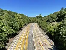
In the 1960s, plans were made to build a freeway for PA 23 between US 30 and PA 772 in Lancaster County. Construction began, but was stopped due to funding issues and public opposition. In 1977, the right-of-way for the freeway was planted over and leased to area farmers, becoming known as the "Goat Path".[29] Traces of the incomplete freeway remain, including bridges over and under local roads, grading for the roadway, and an incomplete interchange with PA 772.[2] Despite the cancellation of the freeway, plans continued for capacity improvements on the PA 23 corridor in eastern Lancaster County due to increased traffic levels.[29] Two proposed alternatives existed to build a new two-lane alignment of PA 23 east of Lancaster. The Bareville Connector Alternative would build a new two-lane PA 23 between the US 30 interchange east of the Conestoga River and Bareville, following the Goat Path and having access to Greenfield Road, Horseshoe Road, and PA 772. In addition, a two-lane Industrial Connector would be built between PA 23 in Bareville and Diller Avenue in New Holland. The Southern Alternative would build a new two-lane PA 23 between the US 30 interchange east of the Conestoga River and US 322 in Blue Ball. The route would utilize the Goat Path and have access to Greenfield Road, Horseshoe Road, PA 772, Diller Avenue, New Holland Road, Ranck Road, and Rancks Church Road.[30] The proposed two-lane bypass would have cost $100 million. In 2010, the project was shelved after the Pennsylvania Department of Transportation (PennDOT) determined it needed the money to repair structurally deficient bridges.[31]
Plans were made in the late 1960s to build the Schuylkill Parkway, a freeway bypass of PA 23 between US 422 and US 202 in Upper Merion Township. In 1972, overhead traffic signals were installed and a portion of the road was built west from US 202 and PA 23 in Bridgeport. Construction was halted after PennDOT ran out of funds to construct the road. The short freeway stub of the Schuylkill Parkway that was built became known as "The Road to Nowhere". In 2002, the Schuylkill Parkway was incorporated into new plans to build a bypass of PA 23 in Upper Merion Township, this time as a surface road that would connect and improve existing roads. Nothing has come from these plans so far. The Schuylkill Parkway freeway stub has been used as a filming location as well as for training emergency vehicle drivers and for commercial vehicle driver tests.[32] It is maintained by PennDOT as State Route 3021, an unsigned quadrant route.[10]
Major intersections
| County | Location | mi[1] | km | Destinations | Notes |
|---|---|---|---|---|---|
| Lancaster | Marietta–East Donegal Township line | 0.000 | 0.000 | Western terminus | |
| East Hempfield Township | 9.541 | 15.355 | |||
| Lancaster | 11.565 | 18.612 | West end of PA 462 westbound concurrency | ||
| 12.451 | 20.038 | Southbound only | |||
| 12.651 | 20.360 | Northbound only | |||
| 12.851 | 20.682 | Northbound only | |||
| 13.551 | 21.808 | East end of PA 462 westbound concurrency | |||
| 15.114 | 24.324 | Interchange; west end of US 30 concurrency; Goat Path continues east from here | |||
| Manheim Township | 15.673 | 25.223 | Interchange; east end of US 30 concurrency | ||
| Upper Leacock Township | 20.793 | 33.463 | West end of PA 772 concurrency | ||
| 21.036 | 33.854 | East end of PA 772 concurrency | |||
| East Earl Township | 29.100 | 46.832 | |||
| 29.637 | 47.696 | West end of PA 897 concurrency | |||
| 30.159 | 48.536 | East end of PA 897 concurrency | |||
| 30.486 | 49.062 | Southern terminus of PA 625 | |||
| Caernarvon Township | 37.316 | 60.054 | West end of PA 10 concurrency | ||
| Berks | Caernarvon Township | 37.515 | 60.375 | Exit 2 on I-176; access to northbound I-176 and from southbound I-176; access via SR 2089; former I-176 routing | |
| 37.962 | 61.094 | East end of PA 10 concurrency | |||
| 40.191 | 64.681 | Western terminus of PA 401 | |||
| Chester | Elverson | 41.017 | 66.010 | Northern terminus of PA 82 | |
| Warwick Township | 43.314 | 69.707 | |||
| South Coventry Township | 50.288 | 80.931 | |||
| East Pikeland Township | 57.081 | 91.863 | Eastern terminus of PA 724 | ||
| Phoenixville | 58.168 | 93.612 | West end of PA 113 concurrency | ||
| 58.636 | 94.365 | East end of PA 113 concurrency | |||
| 59.501 | 95.758 | ||||
| Montgomery | Upper Merion Township | 63.034 | 101.443 | Northern terminus of PA 252 | |
| 65.573 | 105.530 | Interchange | |||
| Bridgeport | 69.764 | 112.274 | Ramp from southbound US 202 to PA 23 | ||
| 69.942 | 112.561 | ||||
| Upper Merion Township | 72.357 | 116.447 | Northern terminus of PA 320 | ||
| West Conshohocken | 73.716 | 118.634 | Exits 331B (I-76 eastbound) & 332 (I-76 westbound); Exit 16A (I-476 northbound); no exit number from I-476 southbound | ||
| Montgomery–Philadelphia county line | Lower Merion Township–Philadelphia line | 81.144 | 130.589 | Eastern terminus | |
1.000 mi = 1.609 km; 1.000 km = 0.621 mi
| |||||
Special routes
King of Prussia alternate truck route
PA Route 23 Alternate Truck | |
|---|---|
| Location | Upper Merion Township |
| Length | 5.1 mi[33] (8.2 km) |
| Existed | 2013–present |
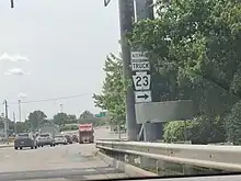
Pennsylvania Route 23 Alternate Truck (PA 23 Alt. Truck) is a truck route around a weight-restricted bridge over the Trout Creek in Upper Merion Township, on which trucks over 32 tons and combination loads over 40 tons are prohibited.
The route follows Gulph Road, US 202, and Henderson Road. It was signed in 2013.[33][34]
Former Phoenixville alternate truck route
PA Route 23 Alternate Truck | |
|---|---|
| Location | East Pikeland Township-Upper Merion Township |
| Length | 16.0 mi (25.7 km) |
| Existed | 2013–2017 |
Pennsylvania Route 23 Alternate Truck (PA 23 Alt. Truck) was a truck route around a formerly weight-restricted bridge over the French Creek in Phoenixville, on which trucks over 22 tons and combination loads over 26 tons were prohibited.
The route followed PA 724, Bridge Street, Main Street, Township Line Road, and US 422.
It was signed in 2013 and decommissioned by Fall 2017 with the rehabilitation of the bridge over French Creek allowing for the removal of the weight restriction.
Former Lower Merion alternate route
Pennsylvania Route 23 Alternate | |
|---|---|
| Location | Upper Merion Township-Lower Merion Township |
| Existed | 1937–1967 |
Pennsylvania Route 23 Alternate (PA 23 Alt.) was an alternate route of PA 23 in Montgomery County.
The route began at PA 23 (Gulph Road) in Upper Merion Township and headed southeast on Montgomery Avenue into Lower Merion Township, reaching an intersection with PA 320.
PA 23 Alt. continued southeast and passed through Narberth before it ended at another intersection with PA 23 (Conshohocken State Road) in Bala Cynwyd.[21]
PA 23 Alt. was designated in 1937.[35]
The alternate route was decommissioned in 1967, with PA 320 replacing the route north of Spring Mill Road.[22]
Former Valley Forge truck route
Pennsylvania Route 23 Truck | |
|---|---|
| Location | Upper Merion Township |
| Existed | 1950–1967 |
Pennsylvania Route 23 Truck (PA 23 Truck) was a truck route around the section of PA 23 that followed Gulph Road through Valley Forge Park.
The truck route began at PA 23 near the community of Valley Forge and headed east concurrent with PA 363 on Valley Forge Road. At Port Kennedy, PA 363 turned north and PA 23 Truck headed south to rejoin PA 23 near King of Prussia.[21]
PA 23 Truck was designated by 1950, following PA 363 along Valley Forge Road and replacing PA 652 between Port Kennedy and King of Prussia.[20]
The truck route was decommissioned in 1967, with PA 23 replacing the route along with PA 363 on Valley Forge Road and the route east of there becoming a rerouted PA 363 on North Gulph Road.[22]
See also
References
- Bureau of Maintenance and Operations (January 2015). Roadway Management System Straight Line Diagrams (Report) (2015 ed.). Pennsylvania Department of Transportation. Retrieved June 30, 2015.
- Lancaster County (PDF)
- Berks County (PDF)
- Chester County (PDF)
- Montgomery County (PDF)
- Google (January 7, 2015). "Pennsylvania Route 23" (Map). Google Maps. Google. Retrieved January 7, 2015.
- Lancaster County, Pennsylvania Highway Map (PDF) (Map). PennDOT. 2014. Retrieved December 19, 2014.
- "Interactive Map of Lancaster County". Discover Lancaster. Retrieved October 9, 2017.
- "Amish & PA Dutch Countryside". Discover Lancaster. Retrieved October 9, 2017.
- "Pennsylvania Byways" (PDF). Pennsylvania Department of Transportation. Retrieved July 23, 2021.
- Berks County, Pennsylvania Highway Map (PDF) (Map). PennDOT. 2014. Archived from the original (PDF) on July 18, 2011. Retrieved December 22, 2014.
- Chester County, Pennsylvania Highway Map (PDF) (Map). PennDOT. 2014. Archived from the original (PDF) on November 12, 2011. Retrieved December 19, 2014.
- "Valley Forge National Historical Park". National Park Service. Retrieved February 1, 2017.
- Montgomery County, Pennsylvania Highway Map (PDF) (Map). PennDOT. 2014. Archived from the original (PDF) on July 18, 2011. Retrieved January 5, 2015.
- Ellis, Franklin and Samuel Evans (1883). History of Lancaster County, Pennsylvania with Biographical Sketches of its Pioneers and Prominent Men. Philadelphia: Everts & Peck. p. 313. Retrieved December 19, 2014.
- Map of Pennsylvania Showing State Highways (PDF) (Map). Pennsylvania Department of Highways. 1911. Archived from the original (PDF) on July 5, 2011. Retrieved January 1, 2014.
- Pennsylvania Highway Map (Map). Pennsylvania Department of Highways. 1927. Retrieved December 26, 2007.
- Pennsylvania Highway Map (Philadelphia Metro) (Map). Gulf Oil. 1928. Retrieved November 8, 2007.
- Tourist Map of Pennsylvania (PDF) (Map). Pennsylvania Department of Highways. 1930. Archived from the original (PDF) on July 5, 2011. Retrieved January 1, 2014.
- Tourist Map of Pennsylvania (back) (PDF) (Map). Pennsylvania Department of Highways. 1930. Archived from the original (PDF) on July 18, 2011. Retrieved January 8, 2015.
- Official Road Map of Pennsylvania (back) (PDF) (Map). Pennsylvania Department of Highways. 1940. Archived from the original (PDF) on July 18, 2011. Retrieved January 1, 2014.
- Official Road Map of Pennsylvania (PDF) (Map). Pennsylvania Department of Highways. 1940. Archived from the original (PDF) on July 5, 2011. Retrieved June 24, 2010.
- Montgomery County (PDF) (Map) (Sheet 2 ed.). Pennsylvania Department of Highways. 1945. Retrieved January 27, 2011.
- Official Road Map of Pennsylvania (back) (PDF) (Map). Pennsylvania Department of Highways. 1950. Retrieved January 16, 2014.
- Official Map of Pennsylvania (back) (PDF) (Map). Pennsylvania Department of Highways. 1960. Archived from the original (PDF) on September 30, 2011. Retrieved October 9, 2009.
- Montgomery County (PDF) (Map) (Sheet 1 ed.). Pennsylvania Department of Highways. 1967. Retrieved January 27, 2011.
- Official Map of Pennsylvania (PDF) (Map). Pennsylvania Department of Highways. 1970. Archived from the original (PDF) on July 5, 2011. Retrieved December 17, 2014.
- Official Map of Pennsylvania (back) (PDF) (Map). Pennsylvania Department of Highways. 1970. Archived from the original (PDF) on July 24, 2011. Retrieved December 16, 2014.
- Pennsylvania Official Transportation Map (back) (PDF) (Map). Pennsylvania Department of Transportation. 1980. Archived from the original (PDF) on July 24, 2011. Retrieved January 17, 2014.
- Pennsylvania Official Transportation Map (back) (PDF) (Map). Pennsylvania Department of Transportation. 1989. Retrieved January 17, 2014.
- Federal Highway Administration (2012). "NBI Structure Number: 000000000020986". National Bridge Inventory. Federal Highway Administration.
- Lancaster County, Pennsylvania Highway Map (PDF) (Map). PennDOT. 1995. Retrieved January 8, 2015.
- "Pennsylvania 23 Environmental Impact Statement: Project History". PennDOT. Archived from the original on 2007-09-27. Retrieved November 6, 2007.
- SR 0023, Section EIS (PDF) (Map). Pennsylvania Department of Transportation. April 2007. Archived from the original (PDF) on January 9, 2015. Retrieved January 8, 2015.
- "Route 23 by-pass still a 'goat path'". Lancaster, PA: WGAL-TV. July 6, 2012. Retrieved January 8, 2015.
- Schogol, Marc (May 5, 2002). "New plans for a 'Road to Nowhere'". The Philadelphia Inquirer. Retrieved January 8, 2015.
- Google (April 21, 2014). "overview of Pennsylvania Route 23 Alternate Truck King of Prussia" (Map). Google Maps. Google. Retrieved April 21, 2014.
- "Risk-Based Bridge Postings - State and Local Bridges" (PDF). Pennsylvania Department of Transportation. October 8, 2013. Retrieved December 18, 2014.
- "State Highways Are Renumbered" (PDF). The Philadelphia Inquirer. May 2, 1937. Retrieved February 22, 2017.
