Seibert, Colorado
Seibert is a statutory town in Kit Carson County, Colorado, United States. The population was 172 at the 2020 census.[5]
Seibert, Colorado | |
|---|---|
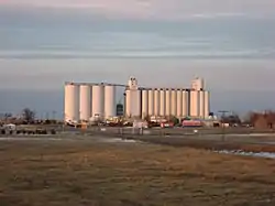 Overview from the south | |
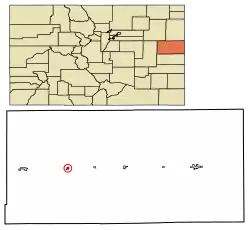 Location of Seibert in Kit Carson County, Colorado. | |
| Coordinates: 39°17′58″N 102°52′13″W | |
| Country | |
| State | |
| County[1] | Kit Carson |
| Incorporated | June 21, 1917[2] |
| Government | |
| • Type | Statutory Town[1] |
| Area | |
| • Total | 0.34 sq mi (0.89 km2) |
| • Land | 0.34 sq mi (0.89 km2) |
| • Water | 0.00 sq mi (0.00 km2) |
| Elevation | 4,711 ft (1,436 m) |
| Population | |
| • Total | 172 |
| • Density | 510/sq mi (190/km2) |
| Time zone | UTC-7 (MST) |
| • Summer (DST) | UTC-6 (MDT) |
| ZIP code[6] | 80834 |
| Area code | 970 |
| FIPS code | 08-69040 |
| GNIS feature ID | 0195118 |
History
A post office called Seibert has been in operation since 1888.[7] The community was named after Henry Seibert, a railroad agent.[8]
Geography
Seibert is located at 39°17′58″N 102°52′13″W (39.299456, -102.870204).[9]
According to the United States Census Bureau, the town has a total area of 0.3 square miles (0.78 km2), all of it land.
Climate
| Climate data for Seibert, Colorado, 1991–2020 normals, extremes 2004–2022 | |||||||||||||
|---|---|---|---|---|---|---|---|---|---|---|---|---|---|
| Month | Jan | Feb | Mar | Apr | May | Jun | Jul | Aug | Sep | Oct | Nov | Dec | Year |
| Record high °F (°C) | 76 (24) |
80 (27) |
83 (28) |
88 (31) |
93 (34) |
107 (42) |
105 (41) |
100 (38) |
97 (36) |
90 (32) |
80 (27) |
73 (23) |
107 (42) |
| Mean maximum °F (°C) | 66.3 (19.1) |
66.5 (19.2) |
76.5 (24.7) |
82.9 (28.3) |
88.9 (31.6) |
98.1 (36.7) |
98.9 (37.2) |
96.5 (35.8) |
93.3 (34.1) |
84.9 (29.4) |
75.0 (23.9) |
66.3 (19.1) |
100.0 (37.8) |
| Average high °F (°C) | 42.5 (5.8) |
44.8 (7.1) |
55.0 (12.8) |
62.5 (16.9) |
71.4 (21.9) |
83.0 (28.3) |
89.1 (31.7) |
85.0 (29.4) |
78.4 (25.8) |
65.0 (18.3) |
51.7 (10.9) |
42.6 (5.9) |
64.3 (17.9) |
| Daily mean °F (°C) | 28.8 (−1.8) |
30.6 (−0.8) |
39.9 (4.4) |
47.3 (8.5) |
57.1 (13.9) |
67.9 (19.9) |
74.0 (23.3) |
71.3 (21.8) |
63.6 (17.6) |
50.8 (10.4) |
38.1 (3.4) |
29.5 (−1.4) |
49.9 (9.9) |
| Average low °F (°C) | 15.2 (−9.3) |
16.3 (−8.7) |
24.9 (−3.9) |
32.1 (0.1) |
42.9 (6.1) |
52.8 (11.6) |
59.0 (15.0) |
57.5 (14.2) |
48.8 (9.3) |
36.6 (2.6) |
24.4 (−4.2) |
16.3 (−8.7) |
35.6 (2.0) |
| Mean minimum °F (°C) | −3.3 (−19.6) |
−2.1 (−18.9) |
8.9 (−12.8) |
19.0 (−7.2) |
29.9 (−1.2) |
42.8 (6.0) |
50.9 (10.5) |
49.6 (9.8) |
35.5 (1.9) |
18.9 (−7.3) |
10.3 (−12.1) |
−3.8 (−19.9) |
−10.1 (−23.4) |
| Record low °F (°C) | −17 (−27) |
−24 (−31) |
−10 (−23) |
6 (−14) |
23 (−5) |
36 (2) |
46 (8) |
45 (7) |
27 (−3) |
1 (−17) |
−13 (−25) |
−18 (−28) |
−24 (−31) |
| Average precipitation inches (mm) | 0.28 (7.1) |
0.49 (12) |
1.01 (26) |
1.44 (37) |
2.69 (68) |
2.05 (52) |
2.64 (67) |
2.70 (69) |
1.10 (28) |
1.22 (31) |
0.39 (9.9) |
0.60 (15) |
16.61 (422) |
| Average snowfall inches (cm) | 3.8 (9.7) |
4.2 (11) |
5.8 (15) |
4.6 (12) |
0.8 (2.0) |
0.0 (0.0) |
0.0 (0.0) |
0.0 (0.0) |
0.0 (0.0) |
2.1 (5.3) |
2.4 (6.1) |
5.9 (15) |
29.6 (76.1) |
| Average precipitation days (≥ 0.01 in) | 2.9 | 3.0 | 3.9 | 5.2 | 8.0 | 5.0 | 7.4 | 7.2 | 4.4 | 4.2 | 2.8 | 3.5 | 57.5 |
| Average snowy days (≥ 0.1 in) | 2.6 | 2.5 | 2.6 | 2.0 | 0.2 | 0.0 | 0.0 | 0.0 | 0.0 | 0.7 | 2.0 | 3.2 | 15.8 |
| Source 1: NOAA[10] | |||||||||||||
| Source 2: National Weather Service (mean maxima/minima 2006–2020)[11] | |||||||||||||
Demographics
| Census | Pop. | Note | %± |
|---|---|---|---|
| 1920 | 311 | — | |
| 1930 | 273 | −12.2% | |
| 1940 | 249 | −8.8% | |
| 1950 | 346 | 39.0% | |
| 1960 | 210 | −39.3% | |
| 1970 | 192 | −8.6% | |
| 1980 | 180 | −6.2% | |
| 1990 | 181 | 0.6% | |
| 2000 | 180 | −0.6% | |
| 2010 | 181 | 0.6% | |
| 2020 | 172 | −5.0% | |
| U.S. Decennial Census | |||
See also
References
- "Active Colorado Municipalities". State of Colorado, Department of Local Affairs. Archived from the original on 2009-12-12. Retrieved 2007-09-01.
- "Colorado Municipal Incorporations". State of Colorado, Department of Personnel & Administration, Colorado State Archives. 2004-12-01. Retrieved 2007-09-02.
- "2019 U.S. Gazetteer Files". United States Census Bureau. Retrieved July 1, 2020.
- "US Board on Geographic Names". United States Geological Survey. 2007-10-25. Retrieved 2008-01-31.
- United States Census Bureau. "Seibert town; Colorado". Retrieved April 22, 2023.
- "ZIP Code Lookup" (JavaScript/HTML). United States Postal Service. Retrieved January 1, 2008.
- "Post offices". Jim Forte Postal History. Retrieved 9 July 2016.
- Dawson, John Frank. Place names in Colorado: why 700 communities were so named, 150 of Spanish or Indian origin. Denver, CO: The J. Frank Dawson Publishing Co. p. 46.
- "US Gazetteer files: 2010, 2000, and 1990". United States Census Bureau. 2011-02-12. Retrieved 2011-04-23.
- "U.S. Climate Normals Quick Access – Station: Seibert, CO". National Oceanic and Atmospheric Administration. Retrieved March 5, 2023.
- "NOAA Online Weather Data – NWS Goodland". National Weather Service. Retrieved March 5, 2023.
External links
Wikimedia Commons has media related to Seibert, Colorado.
Municipalities and communities of Kit Carson County, Colorado, United States | ||
|---|---|---|
| City |  Map of Colorado highlighting Kit Carson County | |
| Towns | ||
This article is issued from Wikipedia. The text is licensed under Creative Commons - Attribution - Sharealike. Additional terms may apply for the media files.