Sentech

Sentech is the signal distributor for the South African broadcasting sector.

Sentech
Agency overview
Formed1992
JurisdictionGovernment of South Africa
HeadquartersJohannesburg, Gauteng,
South Africa
Agency executive
  • Mlamli Booi [1], CEO and Executive Director
Websitesentech.co.za

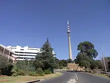
The Sentech Tower in Brixton, Johannesburg.

Background

Sentech began operations in 1992 as the signal distributor of the South African Broadcasting Corporation (SABC). Sentech's mandate also included providing services to M-Net, Radio 702, Radio Ciskei, Radio Transkei and the Bophuthatswana Broadcasting Corporation.

However, in its Triple Inquiry report that was published in August 1995, the Independent Broadcasting Authority (IBA) recommended that Sentech should be split from the SABC and that Sentech become a public company. This report was approved by the South African Parliament in March 1996 and the Sentech Act to implement these measures was adopted by Parliament in November of the same year.

Sentech now operates as a commercial enterprise owned by the Government of South Africa via the Department of Communications and has its own board of directors.

From 2021 Sentech covers many areas of the country by Digital Terrestrial Television or Direct-to-Home platform[2]


Main radio/TV sites

Province Historical Province Location Height of tower Transmitter Coordinates
Eastern Cape Cape Province Aliwal North 143 m 30°47′6″S 26°33′58″E
Western Cape Beaufort West 204 m 32°15′30″S 22°30′23″E
Eastern Cape Bedford 143 m 32°37′57″S 26°2′56″E
Free State Orange Free State Bethlehem 174 m 28°14′12″S 28°29′57″E
Free State Bloemfontein 204 m 29°6′13″S 26°13′47″E
Free State Boesmanskop 235 m 30°0′28″S 27°12′53″E
Eastern Cape Cape Province Butterworth 235 m 32°16′35″S 28°12′24″E
Northern Cape Calvinia 213.5 m 31°23′3″S 19°46′56″E
Western Cape Cape Town (Constantiaberg) 146 m 34°3′16″S 18°23′12″E
Northern Cape Carnarvon 244 m 30°54′15″S 22°22′27″E
Mpumalanga Transvaal Carolina (The Brook) 213.5m 26°10′27″S 30°38′6″E
North West Province Christiana 233 m 27°53′4″S 24°55′47″E
Eastern Cape Cape Province Cradock 174 m 32°18′2″S 25°32′26″E
Mpumalanga Transvaal Davel 265 m 26°27′32″S 29°37′25″E
Northern Cape Cape Province De Aar 204 m 30°27′50″S 23°59′13″E
KwaZulu-Natal Natal Donnybrook 122 m 29°54′58″S 29°51′18″E
Northern Cape Cape Province Douglas 242 m 29°4′8″S 23°31′43″E
Mpumalanga Transvaal Dullstroom 25°34′23″S 30°11′16″E
KwaZulu-Natal Natal Durban (Alverstone) 247 m 29°46′12″S 30°43′0″E
Eastern Cape Cape Province East London 204 m 32°56′21″S 27°48′55″E
KwaZulu-Natal Natal Eshowe 143 m 28°51′32″S 31°17′35″E
Northern Cape Cape Province Faans Grove 146 m 27°6′0″S 22°24′16″E
Northern Cape Garies 213.5 m 30°18′53″S 18°4′40″E
Western Cape George 143 m 33°55′39″S 22°27′1″E
KwaZulu-Natal Natal Glencoe (Fort Mistake) 143 m 28°9′5″S 29°56′51″E
Eastern Cape Cape Province Graaff Reinet 32°4′48″S 24°26′59″E
Eastern Cape Grahamstown 204 m 33°17′15″S 26°42′30″E
KwaZulu-Natal Natal Greytown 174 m 29°0′47″S 30°32′9″E
Limpopo Transvaal Hoedspruit 24°32′32″S 30°52′7″E
Gauteng Johannesburg 237 m 26°11′33″S 28°0′25″E
Eastern Cape Cape Province Kareedouw 34°1′30″S 24°25′47″E
Northern Cape Kimberley 235 m 28°51′15″S 24°54′17″E
Eastern Cape King William's Town (Keiskammahoek) 174 m 32°40′48″S 27°15′36″E
North West Province Transvaal Klerksdorp (Hartbeesfontein) 265 m 26°45′15″S 26°24′28″E
Free State Orange Free State Kroonstad 235 m 27°25′17″S 27°11′7″E
Northern Cape Cape Province Kuruman Hills 241 m 27°53′13″S 23°33′37″E
Free State Orange Free State Ladybrand 174 m 29°10′19″S 27°22′41″E
Limpopo Transvaal Louis Trichardt 143 m 23°0′5″S 29°45′27″E
Eastern Cape Cape Province Matatiele 213.5 m 30°23′47″S 28°49′15″E
Western Cape Matjiesfontein 143 m 33°16′54″S 20°30′17″E
Mpumalanga Transvaal Middelburg 244 m 25°49′6″S 29°23′23″E
KwaZulu-Natal Natal Mooi River 174 m 29°11′9″S 29°52′3″E
Eastern Cape Cape Province Mount Ayliff 137 m 30°50′14″S 29°23′41″E
Western Cape Napier (Bredasdorp) 143 m 34°31′46″S 19°53′33″E
Mpumalanga Transvaal Nelspruit 25°30′57″S 30°46′33″E
KwaZulu-Natal Natal Nongoma 183 m 27°54′19″S 31°39′26″E
Eastern Cape Cape Province Noupoort 174 m 31°18′14″S 24°55′59″E
Western Cape Oudtshoorn 143 m 33°40′17″S 22°16′1″E
Free State Orange Free State Petrus Steyn 235 m 27°31′1″S 28°19′6″E
Mpumalanga Transvaal Piet Retief 265 m 27°1′13″S 30°41′2″E
Western Cape Cape Province Piketberg 174 m 32°49′9″S 18°44′17″E
Eastern Cape Port Elizabeth 204 m 33°56′10″S 25°26′27″E
KwaZulu-Natal Natal Port Shepstone 204 m 30°44′8″S 30°17′16″E
Limpopo Transvaal Potgietersrus 24°9′26″S 29°14′9″E
Gauteng Transvaal Pretoria 113 m 25°41′22″S 27°59′2″E
Northern Cape Cape Province Prieska 244 m 29°40′54″S 22°36′55″E
Eastern Cape Queenstown 143 m 31°43′58″S 26°47′3″E
Western Cape Riversdale 143 m 34°1′8″S 21°7′39″E
North West Province Transvaal Rustenburg 113 m 25°36′59″S 27°7′5″E
North West Province Schweizer-Reneke 265 m 27°8′10″S 25°13′7″E
Free State Orange Free State Senekal 235 m 28°15′21″S 27°30′25″E
Northern Cape Cape Province Springbok 241 m 29°35′4″S 17°48′26″E
Free State Orange Free State Springfontein 143 m 30°16′15″S 25°46′7″E
Eastern Cape Cape Province Suurberg 204 m 33°14′55″S 25°34′27″E
Limpopo Transvaal Thabazimbi 183 m 24°28′2″S 27°36′50″E
Free State Orange Free State Theunissen 265 m 28°11′56″S 26°34′48″E
Limpopo Transvaal Tzaneen (Houtbosdorp) 23°47′7″S 30°0′16″E
KwaZulu-Natal Natal Ubombo 27°33′44″S 32°4′50″E
Eastern Cape Cape Province Umtata 235 m 31°35′49″S 28°44′36″E
Northern Cape Upington 244 m 28°52′58″S 21°44′11″E
Western Cape Vanrhynsdorp 183 m 31°45′16″S 18°41′21″E
Western Cape Villiersdorp 143 m 33°58′10″S 19°30′22″E
Mpumalanga Transvaal Volksrust 174 m 27°18′36″S 29°53′15″E
KwaZulu-Natal Natal Vryheid 143 m 27°44′29″S 30°47′37″E
Gauteng Transvaal Welverdiend 143 m 26°26′49″S 27°14′53″E
North West Province Zeerust (Ottoshoop) 264 m 25°51′38″S 26°2′50″E

See also

References

  1. "Executive members". Sentech. Retrieved 17 November 2019.
  2. Coverage Information service map Sentech.co.za 2021
This article is issued from Wikipedia. The text is licensed under Creative Commons - Attribution - Sharealike. Additional terms may apply for the media files.