Serang
Serang (Indonesian: Kota Serang, Indonesian pronunciation: [kota sɛraŋ], Sundanese: ᮞᮦᮛᮀ) is a city and the capital of Banten province and was formerly also the administrative center of Serang Regency in Indonesia (the Regency's capital is now at Ciruas). The city is located towards the north of Banten province, on the island of Java; the north part of the city (Kasemen District) contains the coast zone facing onto Banten Bay, and includes the historical site of Old Banten, after which the province is named. Before Banten province was formed in 2000, Serang city was part of West Java province.
Serang
ᮞᮦᮛᮀ | |
|---|---|
Pulau Dua Nature Reserve Serang Railway Station | |
 Flag  Seal | |
| Nickname: Paddy Field City | |
| Motto(s): Kota Serang Madani (Self-reliant City of Serang) | |
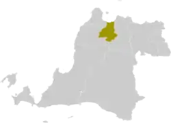 Location within Banten | |
| Coordinates: 6°7′12″S 106°9′1″E | |
| Country | |
| Region | Java |
| Province | |
| Established | 2 November 2007[1] |
| Government | |
| • Mayor | Syafrudin |
| • Vice Mayor | Subadri Ushuludin |
| Area | |
| • Total | 266.18 km2 (102.77 sq mi) |
| Elevation | 25 m (82 ft) |
| Population (mid 2022 estimate) | |
| • Total | 720,362 |
| • Density | 2,700/km2 (7,000/sq mi) |
| [2] | |
| Time zone | UTC+7 (Indonesia Western Time) |
| Area code | (+62) 254 |
| Registration plate | A |
| Website | serangkota.go.id |


Serang has a tropical rainforest climate, with no dry season month.[3] It faces the Java Sea, which is home to the Thousand Islands.
Serang had a population of 576,961 in the 2010 census,[4] making it the third most populous city in the province of Banten. The 2020 Census gave a total of 692,101;[5] the official estimate as at mid 2022 was 720,362.[2] Serang is located approximately 15 km from the border of Jabodetabek (the Jakarta Metropolitan Area), and is sometimes considered as amalgamated with Greater Jakarta.
Culture
Religion

The majority of people in Serang and Banten Province embrace Islam, but other religions coexist peacefully. Serang is often known as "kota santri" or the "city of pious people", due to the history as a traditional center of Islamic learning.[6] The city hosts two of the major congregational mosques in Banten province, Ats-Tsauroh Great Mosque of Serang and Al-Bantani Grand Mosque, which hold the capacity of 2,500 and 10,000 worshippers respectively.[7][8]
Language
Compared with the majority in Banten Province who speak the Sundanese language, some local residents in Serang also speak the Javanese language with a dialect similar to the Cirebon dialect of Javanese. The reason for this is that many Javanese migrants arrived in early 1527 to build the Banten Sultanate, and remained to form the base of today's population.
Transportation
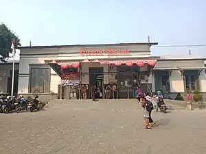
The city is served by Serang station, operated by Indonesia's rail operator PT Kereta Api Indonesia.
The Tangerang–Merak Toll Road, part of the Trans-Java toll road, passes through the city of Serang.
The road to the proposed Sunda Strait Bridge would start in Serang, pass through Merak in neighboring Cilegon city to cross over the Sunda Strait to Sumatra.
Administrative districts
Serang was formerly a part of Serang Regency. On 2 November 2007, the status of Serang was changed into a municipality (kota madya), independent of the Regency. Since that time, Serang City is a semi-enclave within Serang Regency, as the city borders the regency in the south, east, and west, while it borders with Java Sea in the north.
The City of Serang is divided into six districts (kecamatan), tabulated below with their areas and their populations at the 2010 Census[4] and the 2020 Census,[5] together with the official estimates as at mid 2022.[2] The table also includes the number of administrative villages (urban kelurahan) in each district, and its postal codes.
| Name of District (kecamatan) | Area in km2 | Pop'n Census 2010 | Pop'n Census 2020 | Pop'n Estimate mid 2022 | No. of villages | Post codes |
|---|---|---|---|---|---|---|
| Curug | 38.96 | 47,308 | 57,346 | 59,783 | 10 | 47171 |
| Walantaka | 36.56 | 75,672 | 102,543 | 109,232 | 14 | 47183 |
| Cipocok Jaya | 34.10 | 80,930 | 98,907 | 103,274 | 8 | 47121 - 47128 |
| Serang (district) | 26.55 | 208,017 | 226,196 | 230,901 | 12 | 47111 - 47119 |
| Taktakan | 61.55 | 78,184 | 100,296 | 105,711 | 13 | 47162 |
| Kasemen | 68.55 | 87,674 | 106,813 | 111,461 | 10 | 47191 |
| Totals | 266.18 | 577,785 | 692,101 | 720,362 | 66 |
Climate
Serang has a tropical rainforest climate (Af) with heavy rainfall year-round. Rain gets noticeably heavier from December to March.
| Climate data for Serang | |||||||||||||
|---|---|---|---|---|---|---|---|---|---|---|---|---|---|
| Month | Jan | Feb | Mar | Apr | May | Jun | Jul | Aug | Sep | Oct | Nov | Dec | Year |
| Average high °C (°F) | 30.4 (86.7) |
30.9 (87.6) |
31.4 (88.5) |
32.0 (89.6) |
32.3 (90.1) |
32.2 (90.0) |
32.3 (90.1) |
32.3 (90.1) |
32.8 (91.0) |
32.8 (91.0) |
32.4 (90.3) |
31.7 (89.1) |
32.0 (89.5) |
| Daily mean °C (°F) | 26.4 (79.5) |
26.9 (80.4) |
27.5 (81.5) |
27.9 (82.2) |
27.5 (81.5) |
27.1 (80.8) |
27.1 (80.8) |
27.2 (81.0) |
27.3 (81.1) |
27.9 (82.2) |
27.9 (82.2) |
27.2 (81.0) |
27.3 (81.2) |
| Average low °C (°F) | 22.5 (72.5) |
22.6 (72.7) |
22.5 (72.5) |
22.7 (72.9) |
22.8 (73.0) |
22.1 (71.8) |
21.6 (70.9) |
21.4 (70.5) |
21.8 (71.2) |
22.3 (72.1) |
22.7 (72.9) |
22.8 (73.0) |
22.3 (72.2) |
| Average precipitation mm (inches) | 305 (12.0) |
257 (10.1) |
197 (7.8) |
154 (6.1) |
132 (5.2) |
85 (3.3) |
86 (3.4) |
82 (3.2) |
82 (3.2) |
119 (4.7) |
162 (6.4) |
217 (8.5) |
1,878 (73.9) |
| Source: [9] | |||||||||||||
Emblem
The emblem of Serang consists of
- A hexagon with an image of the gerbang Kaibon and a star.
- The streamer at the foot of the emblem contains the motto of Serang city, Kota Serang Madani ("Self-reliant Serang").
References
- according to Law UU No. 32/2007
- Badan Pusat Statistik, Jakarta, 2023, Kota Serang Dalam Angka 2023 (Katalog-BPS 1102001.3673)
- "Serang, Indonesia Travel Weather Averages (Weatherbase)". Weatherbase.
- Biro Pusat Statistik, Jakarta, 2011.
- Badan Pusat Statistik, Jakarta, 2021.
- Mencari Kota Santri. Times Indonesia. Retrieved April 2, 2021.
- Masjid Agung Ats Tsauroh. Dunia Masjid. Retrieved April 29, 2021.
- MASJID AL-BANTANI. Sistem Informasi Masjid. Retrieved April 30, 2021.
- "Serang climate: Average Temperature, weather by month, Serang weather averages - Climate-Data.org". en.climate-data.org.
External links
 Media related to Serang at Wikimedia Commons
- (in Indonesian) Official website
- (in Indonesian) List of Tours in Serang City, Banten
- List of Subdistricts, Villages, and Postal Codes of the Serang City
Provincial capitals in Indonesia | ||
|---|---|---|
| Sumatra | ||
| Java | ||
| Kalimantan | ||
| Lesser Sunda | ||
| Sulawesi | ||
| Maluku | ||
| Papua | ||
| Former provincial capitals | ||
| 2,000,000 and more | |
|---|---|
| 1,000,000–1,999,999 | |
| 500,000–999,999 | |
| 300,000–499,999 | |
| 200,000–299,999 | |