Sherman Island (Antarctica)
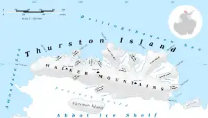
Sherman Island is an ice-covered island of Antarctica about 51 kilometres (32 mi) long and 16 kilometres (10 mi) wide, lying south of Thurston Island in the middle of Peacock Sound. The feature rises above the Abbot Ice Shelf which occupies the sound.
 Sherman Island Location in Antarctica | |
| Geography | |
|---|---|
| Location | Antarctica |
| Coordinates | 72°40′S 99°45′W |
| Area | 1,121 km2 (433 sq mi) |
| Length | 51 km (31.7 mi) |
| Width | 19 km (11.8 mi) |
| Administration | |
| Administered under the Antarctic Treaty System | |
| Demographics | |
| Population | Uninhabited |

Map of Thurston Island.

Satellite image of Thurston Island.
It was delineated from aerial photographs taken by US Navy Operation HIGHJUMP in December 1946, and named by the Advisory Committee on Antarctic Names for Admiral Forrest Sherman, USN, Chief of Naval Operations, when preparations were being made for U.S. Naval support during the forthcoming International Geophysical Year operations.
Maps
- Thurston Island – Jones Mountains. 1:500000 Antarctica Sketch Map. US Geological Survey, 1967.
- Antarctic Digital Database (ADD). Scale 1:250000 topographic map of Antarctica. Scientific Committee on Antarctic Research (SCAR), 1993–2016.
See also
Further reading
- M.J. Hambrey, P.F. Barker, P.J. Barrett, V. Bowman, B. Davies, J.L. Smellie, M. Tranter, Editors, Antarctic Palaeoenvironments and Earth-Surface Processes
- Cochran, J. & Jacobs, S. & Tinto, K. & Bell, Robin. (2014) Bathymetric and oceanic controls on Abbot Ice Shelf thickness and stability, The Cryosphere. 8. 877–889. 10.5194/tc-8-877-2014
- J.A. GRIGGS, J.L. BAMBER, Antarctic ice-shelf thickness from satellite radar altimetry, Journal of Glaciology, Vol. 57, No. 203, 2011, P 485
External links
References
![]() This article incorporates public domain material from "Sherman Island (Antarctica)". Geographic Names Information System. United States Geological Survey.
This article incorporates public domain material from "Sherman Island (Antarctica)". Geographic Names Information System. United States Geological Survey.
This article is issued from Wikipedia. The text is licensed under Creative Commons - Attribution - Sharealike. Additional terms may apply for the media files.
.svg.png.webp)