Shire of Korong
The Shire of Korong was a local government area about 75 kilometres (47 mi) west-northwest of Bendigo, in western Victoria, Australia. The shire covered an area of 238.5 square kilometres (92.1 sq mi), and existed from 1862 until 1995.
| Shire of Korong Victoria | |||||||||||||||
|---|---|---|---|---|---|---|---|---|---|---|---|---|---|---|---|
 Location in Victoria | |||||||||||||||
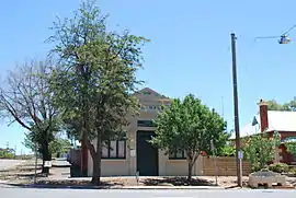 The historic Shire of Korong Hall, at Wedderburn | |||||||||||||||
| Population | 3,480 (1992)[1] | ||||||||||||||
| • Density | 14.591/km2 (37.79/sq mi) | ||||||||||||||
| Established | 1862 | ||||||||||||||
| Area | 238.5 km2 (92.1 sq mi) | ||||||||||||||
| Council seat | Wedderburn | ||||||||||||||
| Region | North Central Victoria | ||||||||||||||
| County | Gladstone | ||||||||||||||
 | |||||||||||||||
History
Korong Shire was first incorporated as the Kingower and Wedderburne road district on 8 July 1862, and was renamed Korong at the time of its redesignation as a shire on 6 September 1864. On 1 February 1961, it annexed the Borough of Inglewood, which had been created a century earlier.[2]
On 20 January 1995, the Shire of Korong was abolished, and along with the Shires of East Loddon and Gordon, the Loddon River district of the former Rural City of Marong, and surrounding districts, was merged into the newly created Shire of Loddon.[3]
Wards
The Shire of Korong was divided into three ridings, each of which elected three councillors:
- Central Riding
- North Riding
- South Riding
Towns and localities
- Borung
- Fernihurst
- Glenalbyn
- Inglewood
- Kingower
- Korong Vale
- Rheola
- Wedderburn*
- Wychitella
* Council seat.
Population
| Year | Population |
|---|---|
| 1954 | 3,943 |
| 1958 | 4,030* |
| 1961 | 3,816 |
| 1966 | 3,662 |
| 1971 | 3,203 |
| 1976 | 3,098 |
| 1981 | 3,029 |
| 1986 | 3,347 |
| 1991 | 3,341 |
* Estimate in the 1958 Victorian Year Book.
References
- Australian Bureau of Statistics, Victoria Office (1994). Victorian Year Book. pp. 49–52. ISSN 0067-1223.
- Victorian Municipal Directory. Brunswick: Arnall & Jackson. 1992. pp. 724–725. Accessed at State Library of Victoria, La Trobe Reading Room.
- Australian Bureau of Statistics (1 August 1995). Victorian local government amalgamations 1994-1995: Changes to the Australian Standard Geographical Classification (PDF). Commonwealth of Australia. p. 8. ISBN 0-642-23117-6. Retrieved 5 January 2008.