Sicangu Village, South Dakota
Sicangu is an unincorporated community and census-designated place (CDP) in Todd County, South Dakota, United States, within the Rosebud Indian Reservation. It was first listed as a CDP prior to the 2020 census.[2] The population of the CDP was 276 at the 2020 census.[4]
Sicangu Village, South Dakota | |
|---|---|
 Sicangu Village  Sicangu Village | |
| Coordinates: 43°0′50″N 100°34′33″W | |
| Country | United States |
| State | South Dakota |
| County | Todd |
| Area | |
| • Total | 0.24 sq mi (0.62 km2) |
| • Land | 0.24 sq mi (0.62 km2) |
| • Water | 0.00 sq mi (0.00 km2) |
| Elevation | 2,772 ft (845 m) |
| Population | |
| • Total | 276 |
| • Density | 1,159.66/sq mi (448.66/km2) |
| Time zone | UTC-6 (Central (CST)) |
| • Summer (DST) | UTC-5 (CDT) |
| ZIP Code | 69201 (Valentine, NE) |
| Area code | 605 |
| FIPS code | 46-58680 |
| GNIS feature ID | 2813064[2] |
It is in the southern part of the county, on the east side of U.S. Route 83. It is 1 mile (1.6 km) north of the Nebraska border and 21 miles (34 km) south of Mission.
References
- "ArcGIS REST Services Directory". United States Census Bureau. Retrieved October 15, 2022.
- U.S. Geological Survey Geographic Names Information System: Sicangu Village, South Dakota
- "Census Population API". United States Census Bureau. Retrieved October 15, 2022.
- "U.S. Census Bureau: Sicangu Village CDP, South Dakota". www.census.gov. United States Census Bureau. Retrieved December 22, 2021.
- "Census of Population and Housing". Census.gov. Retrieved June 4, 2016.
Municipalities and communities of Todd County, South Dakota, United States | ||
|---|---|---|
| City | 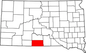 | |
| Town | ||
| CDPs | ||
| Other communities | ||
| Indian reservation | ||
| Footnotes | ‡This populated place also has portions in an adjacent county or counties | |
This article is issued from Wikipedia. The text is licensed under Creative Commons - Attribution - Sharealike. Additional terms may apply for the media files.