Sint-Maartensdijk
Sint-Maartensdijk is a village in the Dutch province of Zeeland. It is a part of the municipality of Tholen, and lies about 16 km west of Bergen op Zoom.
Sint-Maartensdijk | |
|---|---|
Village | |
1.JPG.webp) Dutch Reformed church | |
 Flag  Coat of arms | |
 Sint-Maartensdijk Location in the province of Zeeland in the Netherlands  Sint-Maartensdijk Sint-Maartensdijk (Netherlands) | |
| Coordinates: 51°32′52″N 4°4′30″E | |
| Country | Netherlands |
| Province | Zeeland |
| Municipality | Tholen |
| Area | |
| • Total | 22.26 km2 (8.59 sq mi) |
| Elevation | 1.0 m (3.3 ft) |
| Population (2021)[1] | |
| • Total | 3,440 |
| • Density | 150/km2 (400/sq mi) |
| Time zone | UTC+1 (CET) |
| • Summer (DST) | UTC+2 (CEST) |
| Postal code | 4695[1] |
| Dialing code | 0166 |
History
Sint-Maartensdijk was founded as 'Haestinge', and renamed when it got a church dedicated to Martin of Tours. The first lords of Sint-Maartensdijk resided at Sint-Maartensdijk Castle which was demolished in 1819. The castle was located just north of the town walls, and its southern moat is still visible.
Sint-Maartensdijk was a separate municipality until 1971, when it was merged with Tholen.[3]
Born in Sint-Maartensdijk
- Keetie van Oosten-Hage (born 1949), former cyclist
- Cornelius Vermuyden (1595–1677), engineer
- The Ghanaian politician Alfred Vanderpuije is descended from a Sint-Maartensdijk family
Gallery
 Wind mill and ivy covered house
 View on Sint-Maartendijk (1743)
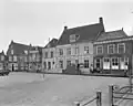 Town hall with neighbouring houses
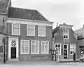 Houses in Sint-Maartensdijk
References
- "Kerncijfers wijken en buurten 2021". Central Bureau of Statistics. Retrieved 22 April 2022.
two entries
- "Postcodetool for 4695BA". Actueel Hoogtebestand Nederland (in Dutch). Het Waterschapshuis. Retrieved 22 April 2022.
- Ad van der Meer and Onno Boonstra, Repertorium van Nederlandse gemeenten, KNAW, 2011.
This article is issued from Wikipedia. The text is licensed under Creative Commons - Attribution - Sharealike. Additional terms may apply for the media files.