Sint Maarten, North Holland
Sint Maarten (West Frisian: Simmer) is a village in the Dutch province of North Holland. It is a part of the municipality of Schagen, and lies about 15 km north of Alkmaar.
Sint Maarten | |
|---|---|
Village | |
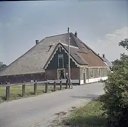
 Farm in Sint Maarten | |
| Coordinates: 52°46′N 4°45′E | |
| Country | Netherlands |
| Province | North Holland |
| Municipality | Schagen |
| Area | |
| • Total | 2.98 km2 (1.15 sq mi) |
| Elevation | −0.7 m (−2.3 ft) |
| Population (2021)[1] | |
| • Total | 945 |
| • Density | 320/km2 (820/sq mi) |
| Time zone | UTC+1 (CET) |
| • Summer (DST) | UTC+2 (CEST) |
| Postal code | 1744[1] |
| Dialing code | 0224 |
The village was first mentioned in 1289 as Niwelant. The current name is a reference to Martin of Tours.[3] Sint Maarten developed in the 13th century along the West-Frisian sea dike. A church was built in 1462, but was destroyed in 1799. In 1875, a new church was built and demolished in 1960.[4][5]
Sint Maarten was home to 246 people in 1840.[5] It was a separate municipality until 1990, when it was merged with Harenkarspel.[6] Harenkarspel merged with Schagen in 2013.[5]
References
- "Kerncijfers wijken en buurten 2021". Central Bureau of Statistics. Retrieved 1 May 2022.
two entries
- "Postcodetool for 1744EG". Actueel Hoogtebestand Nederland (in Dutch). Het Waterschapshuis. Retrieved 1 May 2022.
- "Sint Maarten - (geografische naam)". Etymologiebank (in Dutch). Retrieved 1 May 2022.
- Ronald Stenvert & Saskia van Ginkel-Meester (2006). "Sint Maarten" (in Dutch). Zwolle: Waanders. Retrieved 1 May 2022.
- "Sint Maarten". Plaatsengids (in Dutch). Retrieved 1 May 2022.
- Ad van der Meer and Onno Boonstra, Repertorium van Nederlandse gemeenten, KNAW, 2011.
This article is issued from Wikipedia. The text is licensed under Creative Commons - Attribution - Sharealike. Additional terms may apply for the media files.