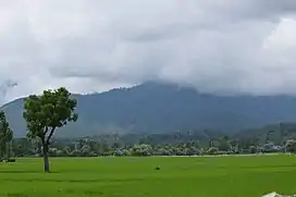
Sogam Lolab
Sogam Lolab is a municipality situated in the Lolab Valley of the Indian union territory of Jammu and Kashmir and is the home of many administrative offices for the area and acts as Sub-District, This place is jurisdiction of Lolab Valley. It is separated by Nagmarg Meadows from Bandipora district to east. Sogam is at an altitude of 1,589 metres (5,213 ft)[1] above the sea level and has a population of about 16,166 with literacy rate of about 79.61%.
Sogam Lolab | |
|---|---|
| Sogam | |
 | |
 Sogam Lolab Sogam Lolab in Jammu and Kashmir | |
| Coordinates: 34°29′50.8″N 74°22′51.8″E[1] | |
| Country | |
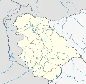
| Union Territory | Jammu and Kashmir |
| District | Kupwara |
| Elevation | 1,696 m (5,564 ft) |
| Population | 16,166 |
| Languages | |
| • Official | Kashmiri, Urdu, Hindi, Dogri, English[2][3] |
References
- "Maps, Weather, and Airports for Sogam, India". www.fallingrain.com. Retrieved 16 March 2018.
- "The Jammu and Kashmir Official Languages Act, 2020" (PDF). The Gazette of India. 27 September 2020. Retrieved 27 September 2020.
- "Parliament passes JK Official Languages Bill, 2020". Rising Kashmir. 23 September 2020. Retrieved 30 May 2021.
This article is issued from Wikipedia. The text is licensed under Creative Commons - Attribution - Sharealike. Additional terms may apply for the media files.