Sognefjellet
Sognefjellet (English: Sogn Mountains)[1][2][3] is a mountainous area and mountain pass which connects Lustrafjorden and its surrounding valley with the Ottadalen valley in the Jotunheimen area. Sognefjellet is located in Luster Municipality (in Vestland county) and Lom Municipality (in Innlandet county) in Norway. Sognefjellsvegen, part of County Road 55, runs through the mountains and over the pass.[4]
| Sognefjellet | |
|---|---|
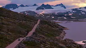 County Road 55 runs through the pass | |
| Location | Innlandet and Vestland, Norway |
| Coordinates | 61.56°N 7.99°E |
Climate
| Climate data for Sognefjellshytta 1991-2020 (1413 m / 4636 ft ASL) | |||||||||||||
|---|---|---|---|---|---|---|---|---|---|---|---|---|---|
| Month | Jan | Feb | Mar | Apr | May | Jun | Jul | Aug | Sep | Oct | Nov | Dec | Year |
| Average high °C (°F) | −6.4 (20.5) |
−7.2 (19.0) |
−5.3 (22.5) |
−0.4 (31.3) |
3.4 (38.1) |
7.9 (46.2) |
10.6 (51.1) |
10.3 (50.5) |
5.4 (41.7) |
0.4 (32.7) |
−3.3 (26.1) |
−6.5 (20.3) |
0.7 (33.3) |
| Daily mean °C (°F) | −8.6 (16.5) |
−9.1 (15.6) |
−8.1 (17.4) |
−4.3 (24.3) |
−0.1 (31.8) |
3.9 (39.0) |
7.4 (45.3) |
6.8 (44.2) |
2.9 (37.2) |
−2.0 (28.4) |
−5.5 (22.1) |
−8.3 (17.1) |
−2.1 (28.2) |
| Average low °C (°F) | −10.9 (12.4) |
−11.9 (10.6) |
−11.1 (12.0) |
−8.1 (17.4) |
−3.2 (26.2) |
0.3 (32.5) |
4.8 (40.6) |
3.9 (39.0) |
0.7 (33.3) |
−4.5 (23.9) |
−7.6 (18.3) |
−10.5 (13.1) |
−4.8 (23.3) |
| Source: seklima.met.no[5] | |||||||||||||
References
- Oxaal, Ivar (2017). On the Trail to Wittgenstein's Hut: The Historical Background of the Tractatus Logico-Philosophicus. Abingdon, UK: Routledge.
- Jahren, Per; Sui, Tongbo (2016). How Water Influences Our Lives. Singapore: Springer. p. 48.
- Ibsen, Henrik (1990). Ibsen Plays: 5: Brand; Emperor and Galilean. London: Bloomsbury Publishing Plc.
- "Sognefjellet". Norwegian Public Roads Administration. Archived from the original on 8 October 2011. Retrieved 5 October 2011.
- "seklima.met.no". Norwegian Meteorological Institute.
This article is issued from Wikipedia. The text is licensed under Creative Commons - Attribution - Sharealike. Additional terms may apply for the media files.