Sonnenstein, Thuringia
Sonnenstein is a municipality in the district of Eichsfeld, Thuringia, Germany. It was formed by the merger of the previously independent municipalities Bockelnhagen, Holungen, Jützenbach, Silkerode, Steinrode, Stöckey, Weißenborn-Lüderode and Zwinge, on 1 December 2011.[2] These municipalities had previously been part of the Verwaltungsgemeinschaft Eichsfeld-Südharz, which was disbanded.[2] The seat of the municipality is in the village Weißenborn-Lüderode.[3] The municipality consists of 8 Ortschaften (municipal divisions): Bockelnhagen (villages Bockelnhagen and Weilrode), Holungen, Jützenbach, Silkerode, Steinrode (villages Werningerode and Epschenrode), Stöckey, Weißenborn-Lüderode and Zwinge.[3]
Sonnenstein | |
|---|---|
Location of Sonnenstein within Eichsfeld district 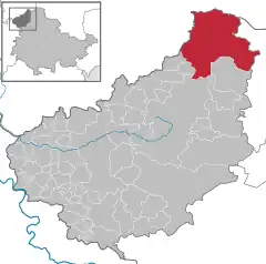 | |
 Sonnenstein  Sonnenstein | |
| Coordinates: 51°32′N 10°25′E | |
| Country | Germany |
| State | Thuringia |
| District | Eichsfeld |
| Area | |
| • Total | 94.51 km2 (36.49 sq mi) |
| Elevation | 240 m (790 ft) |
| Population (2021-12-31)[1] | |
| • Total | 4,433 |
| • Density | 47/km2 (120/sq mi) |
| Time zone | UTC+01:00 (CET) |
| • Summer (DST) | UTC+02:00 (CEST) |
| Postal codes | 37345 |
| Dialling codes | 036072 |
| Vehicle registration | EIC |
| Website | www |
References
- "Bevölkerung der Gemeinden, erfüllenden Gemeinden und Verwaltungsgemeinschaften in Thüringen Gebietsstand: 31.12.2021" (in German). Thüringer Landesamt für Statistik. June 2022.
- Gebietsänderungen vom 01. Januar bis 31. Dezember 2011, Statistisches Bundesamt
- Hauptsatzung der Gemeinde Sonnenstein, 6 April 2022.
This article is issued from Wikipedia. The text is licensed under Creative Commons - Attribution - Sharealike. Additional terms may apply for the media files.