Malabuyoc
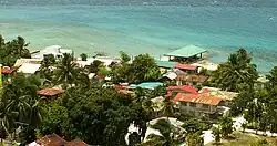
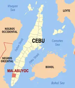
Malabuyoc, officially the Municipality of Malabuyoc (Cebuano: Lungsod sa Malabuyoc; Tagalog: Bayan ng Malabuyoc), is a 5th class municipality in the province of Cebu, Philippines. According to the 2020 census, it has a population of 19,770 people.[3] Malabuyoc is situated in the southwestern coast of the island of Cebu and is 139 kilometres (86 mi) from Cebu City.
Malabuyoc
Buyoc | |
|---|---|
| Municipality of Malabuyoc | |
 Malabuyoc, Cebu | |
| Etymology: Buyoc | |
 Map of Cebu with Malabuyoc highlighted | |
OpenStreetMap | |
.svg.png.webp) Malabuyoc Location within the Philippines | |
| Coordinates: 9°39′N 123°20′E | |
| Country | Philippines |
| Region | Central Visayas |
| Province | Cebu |
| District | 7th district |
| Founded | 1832 |
| Barangays | 14 (see Barangays) |
| Government | |
| • Type | Sangguniang Bayan |
| • Mayor | Erlinda Q. Piedad |
| • Vice Mayor | Anna Devorah D. Allosada |
| • Representative | Peter John D. Calderon |
| • Municipal Council | Members |
| • Electorate | 14,449 voters (2022) |
| Area | |
| • Total | 69.27 km2 (26.75 sq mi) |
| Elevation | 152 m (499 ft) |
| Highest elevation | 718 m (2,356 ft) |
| Lowest elevation | 0 m (0 ft) |
| Population (2020 census)[3] | |
| • Total | 19,770 |
| • Households | 4,463 |
| Demonym | Malabuyocanon |
| Economy | |
| • Income class | 5th municipal income class |
| • Poverty incidence | 27.00 |
| • Revenue | ₱ 92.54 million (2020) |
| • Assets | ₱ 260.9 million (2020) |
| • Expenditure | ₱ 72.45 million (2020) |
| • Liabilities | ₱ 68.97 million (2020) |
| Service provider | |
| • Electricity | Cebu 1 Electric Cooperative (CEBECO 1) |
| Time zone | UTC+8 (PST) |
| ZIP code | 6029 |
| PSGC | |
| IDD : area code | +63 (0)32 |
| Native languages | Cebuano Tagalog |
Malabuyoc is bordered by Alegria in the north, The Tañon Strait in the west, Boljoon in the east, and Ginatilan in the south.
History
According to a popular story, once Malabuyoc grew plenty of fruit trees like mangoes, lanzones, cacaos, and others. So much that the branches of the trees bent down (buyoc in Visaya) under their weight. On account of this, the place came to be called Buyoc.
Malabuyoc is the mother town for Alegria and a contributor town to Ginatilan. Some barangays of both Alegria and Ginatilan were originated from Malabuyoc. Almost half or more than half of the current jurisdictions of Alegria and Ginatilan respectively originally belonged to the jurisdiction of Malabuyoc. If the town of Ginatilan had not been created, Malabuyoc would have been the claimant for the 2nd Filipino Saint: Pedro Calungsod
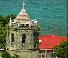
It was officially established as the original municipality of Alegria and Ginatilan. Though the municipality of Ginatilan is a daughter town of Samboan, Malabuyoc was a contributor to Ginatilan. Malabuyoc separated its parish from Samboan in 1832. Its Parish Church was finished in 1834.
Roman Catholic Parishes for these 3 municipalities in the Roman Catholic Archdiocese of Cebu are,
- San Nicolas De Tolentino Parish (F-1834), Malabuyoc, Cebu 6029
- San Gregorio Magno Parish (F-1847), Ginatilan, Cebu 6028
- Saint Francis Xavier Parish (F-1857), Alegria, Cebu 6030
Geography
Barangays
Malabuyoc is politically subdivided into 14 barangays. Each barangay consists of puroks and some have sitios.
| PSGC | Barangay | Population | ±% p.a. | |||
|---|---|---|---|---|---|---|
| 2020[3] | 2010[5] | |||||
| 072229001 | Armeña (Cansilongan) | 4.8% | 950 | 1,016 | −0.67% | |
| 072229015 | Barangay I (Poblacion) | 9.0% | 1,773 | 1,638 | 0.79% | |
| 072229016 | Barangay II (Poblacion) | 5.9% | 1,173 | 1,189 | −0.14% | |
| 072229005 | Cerdeña (Ansan) | 10.2% | 2,011 | 1,993 | 0.09% | |
| 072229006 | Labrador (Bulod) | 3.8% | 744 | 733 | 0.15% | |
| 072229008 | Lombo | 6.7% | 1,327 | 1,441 | −0.82% | |
| 072229007 | Looc | 5.9% | 1,173 | 1,218 | −0.38% | |
| 072229009 | Mahanlud | 3.1% | 605 | 554 | 0.88% | |
| 072229010 | Mindanao (Pajo) | 2.7% | 533 | 532 | 0.02% | |
| 072229011 | Montañeza (Inamlang) | 16.2% | 3,212 | 3,229 | −0.05% | |
| 072229012 | Salmeron (Bulok) | 3.9% | 774 | 763 | 0.14% | |
| 072229013 | Santo Niño (Salering) | 13.8% | 2,721 | 2,509 | 0.81% | |
| 072229014 | Sorsogon (Balikmaya) | 5.9% | 1,159 | 1,015 | 1.34% | |
| 072229004 | Tolosa (Calatagan) | 8.2% | 1,615 | 1,374 | 1.63% | |
| Total | 19,770 | 18,426 | 0.71% | |||
Climate
| Climate data for Malabuyoc, Cebu | |||||||||||||
|---|---|---|---|---|---|---|---|---|---|---|---|---|---|
| Month | Jan | Feb | Mar | Apr | May | Jun | Jul | Aug | Sep | Oct | Nov | Dec | Year |
| Average high °C (°F) | 29 (84) |
29 (84) |
30 (86) |
32 (90) |
31 (88) |
30 (86) |
30 (86) |
30 (86) |
30 (86) |
29 (84) |
29 (84) |
29 (84) |
30 (86) |
| Average low °C (°F) | 23 (73) |
23 (73) |
23 (73) |
24 (75) |
25 (77) |
25 (77) |
24 (75) |
24 (75) |
24 (75) |
24 (75) |
24 (75) |
23 (73) |
24 (75) |
| Average precipitation mm (inches) | 35 (1.4) |
28 (1.1) |
38 (1.5) |
51 (2.0) |
125 (4.9) |
195 (7.7) |
194 (7.6) |
173 (6.8) |
180 (7.1) |
192 (7.6) |
121 (4.8) |
64 (2.5) |
1,396 (55) |
| Average rainy days | 9.2 | 8.2 | 9.9 | 11.3 | 22.5 | 27.3 | 28.0 | 27.2 | 27.1 | 26.9 | 19.7 | 12.7 | 230 |
| Source: Meteoblue [7] | |||||||||||||
Demographics
| Year | Pop. | ±% p.a. |
|---|---|---|
| 1903 | 11,781 | — |
| 1918 | 14,894 | +1.58% |
| 1939 | 13,855 | −0.34% |
| 1948 | 14,096 | +0.19% |
| 1960 | 11,883 | −1.41% |
| 1970 | 12,628 | +0.61% |
| 1975 | 13,993 | +2.08% |
| 1980 | 13,740 | −0.36% |
| 1990 | 14,628 | +0.63% |
| 1995 | 17,090 | +2.96% |
| 2000 | 17,015 | −0.09% |
| 2007 | 18,117 | +0.87% |
| 2010 | 18,426 | +0.62% |
| 2015 | 19,373 | +0.96% |
| 2020 | 19,770 | +0.40% |
| Source: Philippine Statistics Authority[8][5][9][10] | ||
Economy
The main economy is agriculture in particular fruit-bearing trees. There is a cement plant located within, and a power station planned.[18][19][20][21][22]
Tourism

- Binuyocan Festival
The municipality of Malabuyoc launched the Binuyocan Festival on 10 September 2004, in time for the annual town fiesta. Local contingents paraded the streets. Binuyocan Festival has been part of the fiesta celebration in honor of Saint Nicholas of Tolentino since then.
Tourist spots:
- Handigan Falls (Sorsogon)[23]
- Kanspitan Caves (Sorsogon)
- Da-o Cliff (Sorsogon)
- Balugo Falls (Located at the boundaries of Salmeroz, Mahanlud, Mindanao & Sorsogon)
- Ilihan Hills
- Kabutongan Falls
- Kagula Cliff
- Montañeza Falls & Hot Spring
- Moro Watch Tower
- Old Roman Catholic Church
- Talangnan Marine Sanctuary
Education
Tertiary schools:
The public schools in the town of Malabuyoc are administered by one school district under the Schools Division of Cebu Province.
Elementary schools:
- Armeña Elementary School — Armeña
- Calipay Elementary School — Sitio Calipay, Mahanlud
- Cerdeña Elementary School — Cerdeña
- Labrador Elementary School — Labrador
- Lombo Elementary School — Lombo
- Mahanlud Elementary School — Mahanlud
- Malabuyoc Central Elementary School — Barangay II
- Mindanao Elementary School — Mindanao
- Montañeza Elementary School — Montañeza
- Palaypay Elementary School — Sitio Palaypay, Tolosa
- Salmeron Elementary School — Salmeron
- Santo Niño Elementary School — Santo Niño
- Sorsogon Elementary School — Sorsogon
High schools:
- Cerdeña National High School — Cerdeña
- Mahanlud National High School — Mahanlud
- Montañeza National High School — Montañeza
- Sorsogon National High School — Sorsogon
Integrated schools:
- Calatagan Integrated School — Tolosa
- Looc Integrated School — Looc
Private schools:
- Perpetual Succour Academy, Inc. — Barangay II
References
- Municipality of Malabuyoc | (DILG)
- "2015 Census of Population, Report No. 3 – Population, Land Area, and Population Density" (PDF). Philippine Statistics Authority. Quezon City, Philippines. August 2016. ISSN 0117-1453. Archived (PDF) from the original on May 25, 2021. Retrieved July 16, 2021.
- Census of Population (2020). "Region VII (Central Visayas)". Total Population by Province, City, Municipality and Barangay. Philippine Statistics Authority. Retrieved 8 July 2021.
- "PSA Releases the 2018 Municipal and City Level Poverty Estimates". Philippine Statistics Authority. 15 December 2021. Retrieved 22 January 2022.
- Census of Population and Housing (2010). "Region VII (Central Visayas)". Total Population by Province, City, Municipality and Barangay. National Statistics Office. Retrieved 29 June 2016.
- "Cebu Province | PSA Central Visayas Website".
- "Malabuyoc: Average Temperatures and Rainfall". Meteoblue. Retrieved 10 May 2020.
- Census of Population (2015). "Region VII (Central Visayas)". Total Population by Province, City, Municipality and Barangay. Philippine Statistics Authority. Retrieved 20 June 2016.
- Censuses of Population (1903–2007). "Region VII (Central Visayas)". Table 1. Population Enumerated in Various Censuses by Province/Highly Urbanized City: 1903 to 2007. National Statistics Office.
- "Province of Cebu". Municipality Population Data. Local Water Utilities Administration Research Division. Retrieved 17 December 2016.
- "Poverty incidence (PI):". Philippine Statistics Authority. Retrieved December 28, 2020.
- "Estimation of Local Poverty in the Philippines" (PDF). Philippine Statistics Authority. 29 November 2005.
- "2003 City and Municipal Level Poverty Estimates" (PDF). Philippine Statistics Authority. 23 March 2009.
- "City and Municipal Level Poverty Estimates; 2006 and 2009" (PDF). Philippine Statistics Authority. 3 August 2012.
- "2012 Municipal and City Level Poverty Estimates" (PDF). Philippine Statistics Authority. 31 May 2016.
- "Municipal and City Level Small Area Poverty Estimates; 2009, 2012 and 2015". Philippine Statistics Authority. 10 July 2019.
- "PSA Releases the 2018 Municipal and City Level Poverty Estimates". Philippine Statistics Authority. 15 December 2021. Retrieved 22 January 2022.
- "Eagle starts construction of Cebu plant". 24 November 2017.
- "Eagle Cement breaks ground on Cebu plant - SUNSTAR". SunStar. 22 November 2017.
- "Cement plant in Cebu one of big-ticket items - SUNSTAR". SunStar. 18 September 2017.
- "Eagle Cement breaks ground on P12.5-B plant in Cebu". Philippine News Agency.
- "Malabuyoc power station - SourceWatch".
- "- YouTube". YouTube.
- "CTU - Malabuyoc Extension". www.facebook.com.