South Lampung Regency
South Lampung Regency (Indonesian: Kabupaten Lampung Selatan) is a regency of Lampung, Sumatra, Indonesia, a strip of land surrounding the provincial capital of Bandar Lampung on its northern and eastern sides, and bounded to the west by the new Pesawaran Regency and to the south by the Sunda Strait; as such it is a major transit corridor to/from Java island. It has an area of 2,109.74 km2, and a population of 909,989 at the 2010 census[2] and 1,064,301 at the 2020 census;[3] the official estimate as at mid 2022 was 1,081,115.[1] The regency seat is the town of Kalianda.
South Lampung Regency
Kabupaten Lampung Selatan | |
|---|---|
 Seal | |
| Motto(s): Khagom Mufakat (Reaching the consensus) | |
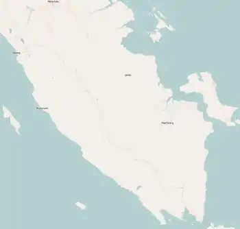
 Location within Lampung | |
| Coordinates: 5.5624299°S 105.5475311°E | |
| Country | Indonesia |
| Province | Lampung |
| Regency seat | Kalianda |
| Government | |
| • Regent | Nanang Ermanto |
| • Vice Regent | Pandu Kesuma Dewangsa, S.I.P. |
| Area | |
| • Total | 2,109.74 km2 (814.58 sq mi) |
| Population (mid 2022 estimate)[1] | |
| • Total | 1,081,115 |
| • Density | 510/km2 (1,300/sq mi) |
| Time zone | UTC+7 (IWST) |
| Area code | (+62) 727 |
| Website | lampungselatankab |

The regency has seen a population influx as migrants escape the crushing population densities and everyday struggles of living in the massive urban paralysis of Greater Jakarta, and along with Bandar Lampung city its character is increasingly reflecting the cosmopolitan makeup of Jakartans rather than the surrounds of a typical provincial capital and hinterland. This has resulted in flaring of ethnic tensions, including rioting.[4]
Administrative Districts
South Lampung Regency consists of seventeen districts (kecamatan), tabulated below with their areas and their populations at the 2010 census[2] and the 2020 census,[3] together with the official estimates as at mid 2022.[1] The districts are grouped below for descriptive convenience into a "Northern zone" comprising the heavily populated areas suburban to Bandar Lampung city, and a "Southern zone" comprising the areas to the southeast of Bandar Lampung; these zones have no administrative significance. The table also includes the locations of the district administrative centres, the number of administrative villages in each district (a total of 256 rural desa and 4 urban kelurahan, the latter all in Kalianda District), and its post code.
| Name of District (kecamatan) | Area in km2 | Pop'n census 2010 | Pop'n census 2020 | Pop'n estimate mid 2022 | Admin centre | No. of villages | Post code |
|---|---|---|---|---|---|---|---|
| Natar | 250.88 | 170,992 | 191,833 | 193,375 | Merak Batin | 26 | 35362 |
| Jati Agung | 164.47 | 103,038 | 128,604 | 132,342 | Marga Agung | 21 | 35365 |
| Tanjung Bintang | 129.72 | 68,572 | 82,184 | 83,911 | Jati Baru | 16 | 35361 |
| Tanjung Sari | 103.32 | 27,107 | 31,822 | 32,361 | Kerto Sari | 8 | 35360 |
| Murbau Mataram | 113.94 | 46,644 | 56,507 | 57,815 | Merbau Mataram | 15 | 35357 |
| Northern zone | 762.33 | 416,353 | 490,950 | 499,804 | 86 | ||
| Katibung (a) | 188.62 | 61,422 | 72,563 | 73,882 | Tanjung Ratu | 12 | 35452 |
| Way Sulan | 46.54 | 21,264 | 24,326 | 24,615 | Karang Pucung | 8 | 35456 |
| Sidomulyo | 158.99 | 57,264 | 65,292 | 66,024 | Sidorejo | 16 | 35352 |
| Candipuro | 84.90 | 50,256 | 57,627 | 58,337 | Titiwangi | 14 | 35356 |
| Way Panji | 38.45 | 16,341 | 18,106 | 18,208 | Sidoharjo | 4 | 35354 |
| Kalianda | 179.82 | 81,126 | 94,127 | 95,504 | Kalianda | 29 | 35551 |
| Rajabasa (b) | 100.39 | 20,769 | 24,849 | 25,363 | Banding | 16 | 35552 |
| Palas | 165.57 | 53,492 | 60,864 | 61,521 | Bangunan | 21 | 35594 |
| Sragi | 93.44 | 31,654 | 35,665 | 35,982 | Kuala Sekampung | 10 | 35597 |
| Penengahan | 124.96 | 35,672 | 42,260 | 43,051 | Pasuruan | 22 | 35593 |
| Ketapang (c) | 108.60 | 46,116 | 53,147 | 53,854 | Bangun Rejo | 17 | 35596 |
| Bakauheni (d) | 57.13 | 20,761 | 24,525 | 24,970 | Hatta | 5 | 35592 |
| Southern zone | 1,347.41 | 493,636 | 573,351 | 581,311 | 174 | ||
| Totals for regency | 2,109.74 | 909,989 | 1,064,301 | 1,081,115 | Kalianda | 260 |
Notes: (a) the district includes 3 islands off the south coast of Sumatra. (b) the district includes 16 islands off the south coast of Sumatra, the largest being Pulau Sebuku, Pulau Sebesi and Pulau Krakatoa. (c) the district includes 10 islands off the south coast of Sumatra. (d) the district includes 12 islands off the south coast of Sumatra.
History
Tanggamus Regency, formerly the most western districts of South Lampung Regency, was separated from it on 3 January 1997. Pesawaran Regency, formerly the most southwestern districts remaining in South Lampung Regency lying to the southwest of Bandar Lampung, was carved out of it on 17 July 2007.
In January 2011, tens of thousands of inhabitants of South Lampung had to be evacuated by the South Lampung Disaster Mitigation Agency (BPBD) in the seven districts of Kalianda, Rajabasa, Katibung, Sidomulyo, Ketapang, Sragi and Palas due to volcanic ash from the Mount Anak Krakatau.[5] There is an observation station at Hargopancuran village in South Lampung used to monitor activity.
See also
References
- Badan Pusat Statistik, Jakarta, 2023, Kabupaten Lampung Selatan Dalam Angka 2023 (Katalog-BPS 1102001.1801)
- Biro Pusat Statistik, Jakarta, 2011.
- Badan Pusat Statistik, Jakarta, 2021.
- "Five arrested for causing S. Lampung riots - Fri, November 23 2012 - The Jakarta Post".
- "Residents to be evacuated as Mt. Anak Krakatau spews ash". Jakarta Post, Bandarlampung. 11 January 2011. Retrieved 22 February 2011.
External links
Regencies and cities of Lampung | ||
|---|---|---|
Capital: Bandar Lampung | ||
| Regencies | ||
| Cities | ||