South Mount Vernon, Ohio
South Mount Vernon is a census-designated place (CDP) in Knox County, Ohio, United States, adjacent to the city of Mount Vernon. It was first listed as a CDP prior to the 2020 census.[2]
South Mount Vernon, Ohio | |
|---|---|
 South Mount Vernon  South Mount Vernon | |
| Coordinates: 40°22′50″N 82°30′19″W | |
| Country | United States |
| State | Ohio |
| County | Knox |
| Township | Clinton |
| Area | |
| • Total | 0.51 sq mi (1.31 km2) |
| • Land | 0.51 sq mi (1.31 km2) |
| • Water | 0.00 sq mi (0.00 km2) |
| Elevation | 1,026 ft (313 m) |
| Population (2020) | |
| • Total | 714 |
| • Density | 1,413.86/sq mi (545.57/km2) |
| Time zone | UTC-5 (Eastern (EST)) |
| • Summer (DST) | UTC-4 (EDT) |
| ZIP Code | 43050 (Mount Vernon) |
| Area code(s) | 740/220 |
| FIPS code | 39-73530 |
| GNIS feature ID | 2806994[2] |
The CDP is west of the center of Knox County, in Clinton Township. It is bordered to the north, east, and south by the city of Mount Vernon. It is bordered to the southeast by Dry Creek, a northeast-flowing tributary of the Kokosing River, part of the Walhonding River and subsequently Muskingum River watersheds leading to the Ohio River.
U.S. Route 36 (Harcourt Road) runs through the west side of the community, leading north and east into Mount Vernon, and southwest 22 miles (35 km) to Sunbury.
References
- "ArcGIS REST Services Directory". United States Census Bureau. Retrieved September 20, 2022.
- "South Mount Vernon Census Designated Place". Geographic Names Information System. United States Geological Survey, United States Department of the Interior.
- "Census of Population and Housing". Census.gov. Retrieved June 4, 2016.
Municipalities and communities of Knox County, Ohio, United States | ||
|---|---|---|
| City | 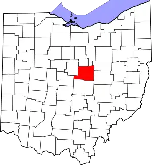 Map of Ohio highlighting Knox County | |
| Villages | ||
| Townships | ||
| CDPs | ||
| Unincorporated communities | ||
| Ghost town | ||
| Footnotes | ‡This populated place also has portions in an adjacent county or counties | |
This article is issued from Wikipedia. The text is licensed under Creative Commons - Attribution - Sharealike. Additional terms may apply for the media files.