Wellfleet, Massachusetts
Wellfleet is a town in Barnstable County, Massachusetts, United States, and is located halfway between the "tip" and "elbow" of Cape Cod. The town had a population of 3,566 at the 2020 census,[1] which swells nearly sixfold during the summer.[2] A total of 70% of the town's land area is under protection, and nearly half of it is part of the Cape Cod National Seashore. Wellfleet is famous for its oysters, which are celebrated in the annual October Wellfleet OysterFest.
Wellfleet, Massachusetts | |
|---|---|
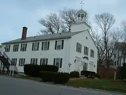
 Wellfleet Town Hall | |
 Seal | |
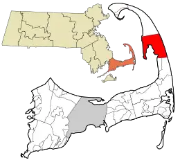
 Location in Barnstable County and the state of Massachusetts. | |
| Coordinates: 41°56′15″N 70°02′00″W | |
| Country | United States |
| State | Massachusetts |
| County | Barnstable |
| Incorporated | 1763 |
| Government | |
| • Type | Open town meeting |
| • Board of Selectmen | Board of Selectmen |
| Area | |
| • Total | 35.4 sq mi (91.7 km2) |
| • Land | 19.8 sq mi (51.3 km2) |
| • Water | 15.6 sq mi (40.5 km2) |
| Elevation | 50 ft (15 m) |
| Population (2020) | |
| • Total | 3,566 |
| • Density | 180/sq mi (69.5/km2) |
| Time zone | UTC−5 (Eastern) |
| • Summer (DST) | UTC−4 (Eastern) |
| ZIP Codes | 02663, 02667 |
| Area code | 508/774 |
| FIPS code | 25-74385 |
| GNIS feature ID | 0618261 |
| Website | www |
History
The area was originally settled by Europeans in the 1650s as Billingsgate (after the famous fish market in East London). In 1717, the pirate "Black Sam" Bellamy was sailing nearby when his ship, the Whydah, sank offshore, together with over 4.5 short tons (4.1 tonnes) of gold and silver and all but two of its 145 men. The wreck was discovered in 1984, the first of only two confirmed pirate shipwrecks ever to have been discovered.[3]
Wellfleet was part of neighboring Eastham until 1763 when it achieved town status after nearly 30 years of petitioning. Wellfleet's oyster beds drove the early economy, as did whaling and fishing. The town was home to 30 whaling ships at the time of the American Revolution.
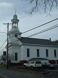
Because of the decline of whaling and the mackerel catch in the late 19th century, the fleet declined, being completely free of schooners by 1900. The oyster fleet continued, however, and many types of shellfish continue to be harvested. Despite this decline, a church near the town center continues to operate a clock that chimes ship’s time.[4]

Guglielmo Marconi built the USA's first transatlantic radio transmitter station on a coastal bluff in South Wellfleet in 1901–1902. The first radio telegraph transmission from the United States to England was sent from this station on January 18, 1903, a ceremonial telegram from President Theodore Roosevelt to King Edward VII. Most of the transmitter site is gone, however, as three quarters of the land it originally encompassed has been eroded into the sea. The South Wellfleet station's first call sign was "CC" for Cape Cod.[5][6]
In 1961, President John F. Kennedy created the Cape Cod National Seashore, which encompasses most of the Atlantic shoreline of Cape Cod. In Wellfleet, the territory circles the town, from Jeremy Point through the marshes and "islands" along the Herring River, includes Cahoon Hollow Beach, and extends the length of the Atlantic shore of the town.
Construction of the Chequessett Inn in the late 19th century contributed to the development of a tourist economy in Wellfleet. The town has the second greatest concentration of art galleries on Cape Cod, right after Provincetown. It is also a popular retirement spot.[7][8]
Geography
According to the United States Census Bureau, the town has a total area of 35.4 square miles (91.7 km2), of which 19.8 square miles (51.3 km2) is land and 15.6 square miles (40.5 km2), or 44.11%, is water.[9] Wellfleet is bordered by Truro to the north, the Atlantic Ocean to the east, Eastham to the south, and Cape Cod Bay to the west. Wellfleet is approximately 14 miles (23 km) south of Provincetown, 33 miles (53 km) (by road) northeast of Barnstable, 48 miles (77 km) from the Sagamore Bridge, and 100 miles (160 km) (by road) southeast of Boston.
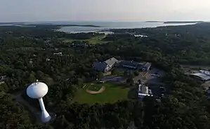
The lands of Wellfleet wrap around Wellfleet Harbor, extending from the main portion of the Cape around the harbor to Jeremy Point. At one time, Wellfleet Harbor included an island known as Billingsgate Island, which sat at the harbor's mouth, to the south of the point. Once a flourishing small community with a lighthouse, the island was destroyed by coastal erosion and now exists as a shoal that is exposed at low tide. The Billingsgate shoals are split between Wellfleet and neighboring Eastham. Several other inlets extend inland from the harbor, at the mouth of the Herring River (also called "The Gut"), Duck Creek, Blackfish Creek and Fresh Brook (commonly known as "The Run") which leads to several brooks.
In addition to the Seashore, Wellfleet Bay Wildlife Sanctuary, run by Massachusetts Audubon, surrounds much of The Run, including part of Small Island (between The Run and Blackfish Creek). Between the sanctuary, seashore and other small parks and beaches, seventy percent of the town's area is protected.
A small whaling community was founded on the land that is now Wellfleet Bay Wildlife Sanctuary, and was originally known as Silver Spring, after Silver Spring Brook. What remains of it is a marsh that was once its harbor, known as the Silver Spring Brook Marshes. This land is now protected by the Massachusetts Audubon Society in its Wellfleet Bay Sanctuary.
Climate
The town of Wellfleet has a mild summer humid continental climate (Dfb). The plant hardiness zone is 7a, with an average annual extreme minimum air temperature of 3.6 °F (−15.7 °C).[10] The average seasonal (Nov–Apr) snowfall total is around 30 in (76 cm). The average snowiest month is February, which corresponds to the annual peak in nor'easter activity.
| Climate data for Wellfleet, Barnstable County, Massachusetts (1981–2010 averages). | |||||||||||||
|---|---|---|---|---|---|---|---|---|---|---|---|---|---|
| Month | Jan | Feb | Mar | Apr | May | Jun | Jul | Aug | Sep | Oct | Nov | Dec | Year |
| Average high °F (°C) | 38.2 (3.4) |
39.5 (4.2) |
44.7 (7.1) |
53.5 (11.9) |
62.8 (17.1) |
72.0 (22.2) |
78.2 (25.7) |
77.4 (25.2) |
70.8 (21.6) |
61.0 (16.1) |
52.8 (11.6) |
44.1 (6.7) |
58.0 (14.4) |
| Daily mean °F (°C) | 31.6 (−0.2) |
32.8 (0.4) |
37.8 (3.2) |
46.3 (7.9) |
55.3 (12.9) |
64.5 (18.1) |
70.9 (21.6) |
70.4 (21.3) |
64.0 (17.8) |
54.4 (12.4) |
46.2 (7.9) |
37.3 (2.9) |
51.0 (10.6) |
| Average low °F (°C) | 25.1 (−3.8) |
26.0 (−3.3) |
30.9 (−0.6) |
39.1 (3.9) |
47.8 (8.8) |
57.1 (13.9) |
63.6 (17.6) |
63.4 (17.4) |
57.3 (14.1) |
47.8 (8.8) |
39.6 (4.2) |
30.5 (−0.8) |
44.1 (6.7) |
| Average precipitation inches (mm) | 3.72 (94) |
3.16 (80) |
4.05 (103) |
4.27 (108) |
3.28 (83) |
3.55 (90) |
2.68 (68) |
3.92 (100) |
3.59 (91) |
4.26 (108) |
4.35 (110) |
3.80 (97) |
44.63 (1,134) |
| Average relative humidity (%) | 70.2 | 68.3 | 67.2 | 68.5 | 70.8 | 74.2 | 76.4 | 76.3 | 76.6 | 72.6 | 69.6 | 68.5 | 71.6 |
| Source: PRISM Climate Group[11] | |||||||||||||
| Month | Jan | Feb | Mar | Apr | May | Jun | Jul | Aug | Sep | Oct | Nov | Dec | Year |
|---|---|---|---|---|---|---|---|---|---|---|---|---|---|
| Average Dew Point °F | 23.0 | 23.5 | 27.9 | 36.5 | 46.0 | 56.1 | 63.1 | 62.6 | 56.5 | 45.8 | 36.8 | 27.9 | 42.2 |
| Average Dew Point °C | −5.0 | −4.7 | −2.3 | 2.5 | 7.8 | 13.4 | 17.3 | 17.0 | 13.6 | 7.7 | 2.7 | −2.3 | 5.7 |
Source = PRISM Climate Group[12] | |||||||||||||
Transportation
U.S. Route 6 passes from north to south through the town. The town's commercial center lies west of the route, along the shores of the harbor. The route was straightened in the mid-20th century, and some maps still consider the "old" Route 6 to be a portion of Route 6A. The town has no rail or air service. The last train left the area in the 1930s, the train station was razed and the tracks were torn up through Provincetown. The old rail line was turned into a bicycle trail, named the Cod Rail Trail, which ends in South Wellfleet. The nearest municipal airports are in Chatham and Provincetown, both about 18 miles (29 km) from town; the nearest national and international service can be found at Logan International Airport in Boston.
There is currently limited bus service between Wellfleet and Hyannis, and from there on to Boston and Logan Airport, on the Plymouth & Brockton Street Railway Company, a Plymouth-based bus service. The CCRTA, which runs between Hyannis and Provincetown, also makes stops in Wellfleet.
Demographics
| Year | Pop. | ±% |
|---|---|---|
| 1850 | 2,411 | — |
| 1860 | 2,322 | −3.7% |
| 1870 | 2,135 | −8.1% |
| 1880 | 1,875 | −12.2% |
| 1890 | 1,291 | −31.1% |
| 1900 | 988 | −23.5% |
| 1910 | 1,022 | +3.4% |
| 1920 | 826 | −19.2% |
| 1930 | 823 | −0.4% |
| 1940 | 890 | +8.1% |
| 1950 | 1,123 | +26.2% |
| 1960 | 1,404 | +25.0% |
| 1970 | 1,743 | +24.1% |
| 1980 | 2,209 | +26.7% |
| 1990 | 2,493 | +12.9% |
| 2000 | 2,749 | +10.3% |
| 2010 | 2,750 | +0.0% |
| 2020 | 3,566 | +29.7% |
| 2022 | 3,644 | +2.2% |
| * = population estimate. Source: United States census records and Population Estimates Program data.[13][14][15][16][17][18][19][20][21][22][23] | ||

As of the census[24] of 2000, there were 2,749 people, 1,301 households, and 724 families residing in the town. The population density was 138.6 inhabitants per square mile (53.5/km2). There were 3,998 housing units at an average density of 201.6 per square mile (77.8/km2). The racial makeup of the town was 96.58% White, 0.95% African American, 0.29% Native American, 0.36% Asian, 0.04% Pacific Islander, 0.58% from other races, and 1.20% from two or more races. Hispanic or Latino of any race were 0.69% of the population.
There were 1,301 households, out of which 20.0% had children under the age of 18 living with them, 44.8% were married couples living together, 8.2% had a female householder with no husband present, and 44.3% were non-families. Of all households, 34.8% were made up of individuals, and 13.2% had someone living alone who was 65 years of age or older. The average household size was 2.11 and the average family size was 2.75.
In the town, the population was spread out, with 17.8% under the age of 18, 4.9% from 18 to 24, 23.3% from 25 to 44, 32.2% from 45 to 64, and 21.7% who were 65 years of age or older. The median age was 47 years. For every 100 females, there were 89.2 males. For every 100 females age 18 and over, there were 83.5 males.
The median income for a household in the town was $43,558, and the median income for a family was $50,990. Males had a median income of $38,100 versus $35,964 for females. The per capita income for the town was $25,712. About 5.7% of families and 7.5% of the population were below the poverty line, including 9.7% of those under age 18 and 6.0% of those age 65 or over.
Government

Wellfleet is represented in the Massachusetts House of Representatives as a part of the Fourth Barnstable district, which includes (with the exception of Brewster) all the towns east and north of Harwich on the Cape. The town is represented in the Massachusetts Senate as a part of the Cape and Islands District, which includes all of Cape Cod, Martha's Vineyard and Nantucket except the towns of Bourne, Falmouth, Sandwich and a portion of Barnstable.[25] Wellfleet is patrolled by the Second (Yarmouth) Barracks of Troop D of the Massachusetts State Police.[26]
On the national level, Wellfleet is a part of the 9th congressional district, currently represented by Bill Keating. The state's senior (Class I) member of the United States Senate, elected in 2012, is Elizabeth Warren. The junior (Class II) senator, elected on April 30, 2013, is Ed Markey.
Wellfleet is governed by the open town meeting form of government and a board of selectmen, who employ a town administrator to oversee day-to-day business. The town has its own police and fire departments, headquartered on Route 6 near the town center. There are two post offices, and both are also located along Route 6. The Wellfleet Public Library is located in the town center, in a former curtain and candle factory converted in 1989.
Education
Wellfleet, Brewster, Truro, Provincetown, Eastham and Orleans make up the Nauset Regional School District. Each town operates its own elementary schools, with a regional middle school and high school accepting the students of all four towns. Wellfleet Elementary School is located just off Route 6 near the town center, and serves students from kindergarten to fifth grade. The Nauset Regional Middle School is located in Orleans, and the Nauset Regional High School is located in neighboring Eastham. There are no private schools in Wellfleet; high school students may, however, choose to attend Cape Cod Regional Technical High School in Harwich free of charge.
Notable people
- Martha Atwood, soprano
- Lorenzo Dow Baker, entrepreneur, pioneer of the American commercialization of bananas
- Samuel Bellamy, pirate
- Berry Berenson, actress, photographer, model
- William Birenbaum (1923–2010), college administrator who served as president of Antioch College[27]
- Serge Chermayeff, architect
- Mike DeVito, NFL player
- Edwin Dickinson, artist
- John Dos Passos, writer
- Janet Doub Erickson, co-founder of the Blockhouse of Boston, artist, and author
- Gilbert Franklin, sculptor, educator[28]
- Bernard Greenhouse, cellist
- John M. Johansen, architect
- Allen Kurzweil, writer
- Robert Jay Lifton, psychiatrist, author
- Guglielmo Marconi, technology pioneer
- Mary McCarthy, writer
- Anthony Perkins, actor, singer, director
- Marge Piercy, poet
- Jane Piper (1916–1991), artist
- Stephen Russell, actor, theater director
- Arthur Schlesinger, Jr., historian
- Edmund Wilson, literary critic
- Howard Zinn, historian
See also
References
- "Census - Geography Profile: Wellfleet town, Barnstable County, Massachusetts". U.S. Census Bureau. Retrieved October 6, 2021.
- "Wellfleet Today". Mass Department of Housing and Community Development community profile. wellfleetma.org. Archived from the original on 23 July 2011. Retrieved 7 July 2011.
- Commonwealth of Massachusetts v. Maritime Underwater Surveys, Inc., 403 Mass. 501 (Mass. Supreme Court 1988).
- Maguire, James "Jerry". "Wellfleet's Tower Clock" (PDF). wellfleetchurch.org. Archived (PDF) from the original on 2022-10-09. Retrieved 2021-03-02.
- "Marconi Wireless On Cape Cod". Archived from the original on 2008-10-24. Retrieved 2008-10-19.
- "Broadcast Archive, Marconi section". Archived from the original on 2008-07-05. Retrieved 2008-10-18.
- "History of Wellfleet, from WellfleetMA.org". Archived from the original on 2007-02-14. Retrieved 2007-02-28.
- Cape Cod, Martha's Vineyard and Nantucket Street Atlas. South Easton, MA: Arrow Maps Inc., 2004, p. 87.
- "Geographic Identifiers: 2010 Demographic Profile Data (G001): Wellfleet town, Barnstable County, Massachusetts". U.S. Census Bureau, American Factfinder. Archived from the original on February 12, 2020. Retrieved December 6, 2013.
- "USDA Interactive Plant Hardiness Map". United States Department of Agriculture. Retrieved 2019-06-28.
- "PRISM Climate Group, Oregon State U". www.prism.oregonstate.edu. Retrieved June 26, 2019.
- "PRISM Climate Group, Oregon State U". www.prism.oregonstate.edu. Retrieved June 27, 2019.
- "Total Population (P1), 2010 Census Summary File 1". American FactFinder, All County Subdivisions within Massachusetts. United States Census Bureau. 2010.
- "Massachusetts by Place and County Subdivision - GCT-T1. Population Estimates". United States Census Bureau. Retrieved July 12, 2011.
- "1990 Census of Population, General Population Characteristics: Massachusetts" (PDF). US Census Bureau. December 1990. Table 76: General Characteristics of Persons, Households, and Families: 1990. 1990 CP-1-23. Retrieved July 12, 2011.
- "1980 Census of the Population, Number of Inhabitants: Massachusetts" (PDF). US Census Bureau. December 1981. Table 4. Populations of County Subdivisions: 1960 to 1980. PC80-1-A23. Retrieved July 12, 2011.
- "1950 Census of Population" (PDF). Bureau of the Census. 1952. Section 6, Pages 21-10 and 21-11, Massachusetts Table 6. Population of Counties by Minor Civil Divisions: 1930 to 1950. Retrieved July 12, 2011.
- "1920 Census of Population" (PDF). Bureau of the Census. Number of Inhabitants, by Counties and Minor Civil Divisions. Pages 21-5 through 21-7. Massachusetts Table 2. Population of Counties by Minor Civil Divisions: 1920, 1910, and 1920. Retrieved July 12, 2011.
- "1890 Census of the Population" (PDF). Department of the Interior, Census Office. Pages 179 through 182. Massachusetts Table 5. Population of States and Territories by Minor Civil Divisions: 1880 and 1890. Retrieved July 12, 2011.
- "1870 Census of the Population" (PDF). Department of the Interior, Census Office. 1872. Pages 217 through 220. Table IX. Population of Minor Civil Divisions, &c. Massachusetts. Retrieved July 12, 2011.
- "1860 Census" (PDF). Department of the Interior, Census Office. 1864. Pages 220 through 226. State of Massachusetts Table No. 3. Populations of Cities, Towns, &c. Retrieved July 12, 2011.
- "1850 Census" (PDF). Department of the Interior, Census Office. 1854. Pages 338 through 393. Populations of Cities, Towns, &c. Retrieved July 12, 2011.
- "City and Town Population Totals: 2020-2022". United States Census Bureau. Retrieved October 21, 2023.
- "U.S. Census website". United States Census Bureau. Retrieved 2008-01-31.
- "Index of Legislative Representation by City and Town, from Mass.gov". Archived from the original on September 29, 2007.
- "Station D-2, SP Yarmouth". Archived from the original on 2007-03-16. Retrieved 2007-02-28.
- Fox, Margalit. "William M. Birenbaum, College Leader, Dies at 87" Archived 2018-02-02 at the Wayback Machine, The New York Times, October 8, 2010. Accessed October 10, 2010.
- Long, Tom (October 30, 2004). "Gilbert Franklin, sculptor noted for public works; at 85". Newspapers.com. The Boston Globe. p. 27. ISSN 0743-1791. Retrieved 2022-03-05.
