Spokane Creek, Montana
Spokane Creek is a census-designated place (CDP) in Broadwater County, Montana, United States. The population was 355 at the 2010 census.[3]
Spokane Creek, Montana | |
|---|---|
 Spokane Creek | |
| Coordinates: 46°32′43″N 111°44′47″W | |
| Country | United States |
| State | Montana |
| County | Broadwater |
| Area | |
| • Total | 17.29 sq mi (44.79 km2) |
| • Land | 17.29 sq mi (44.79 km2) |
| • Water | 0.00 sq mi (0.00 km2) |
| Elevation | 4,278 ft (1,304 m) |
| Population (2020) | |
| • Total | 430 |
| • Density | 24.87/sq mi (9.60/km2) |
| Time zone | UTC-7 (Mountain (MST)) |
| • Summer (DST) | UTC-6 (MDT) |
| Area code | 406 |
| FIPS code | 30-69900 |
| GNIS feature ID | 2583849[2] |
Geography
Radersburg is located in the northwest corner of Broadwater County, 14 miles (23 km) east of Helena, the state capital. 12/287 runs through the CDP, leading west to Helena and southeast 19 miles (31 km) to Townsend. Canyon Ferry Lake, a reservoir on the Missouri River, is 3 miles (5 km) to the east of the CDP.
According to the United States Census Bureau, the CDP has a total area of 17.3 square miles (44.8 km2), all land.[3]
References
- "ArcGIS REST Services Directory". United States Census Bureau. Retrieved September 5, 2022.
- U.S. Geological Survey Geographic Names Information System: Spokane Creek, Montana
- "Geographic Identifiers: 2010 Demographic Profile Data (G001): Spokane Creek CDP, Montana". U.S. Census Bureau, American Factfinder. Archived from the original on February 12, 2020. Retrieved June 26, 2013.
- "Census of Population and Housing". Census.gov. Retrieved June 4, 2016.
Municipalities and communities of Broadwater County, Montana, United States | ||
|---|---|---|
| City | 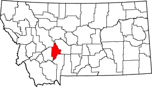 Broadwater County map | |
| CDPs | ||
| Unincorporated community | ||
This article is issued from Wikipedia. The text is licensed under Creative Commons - Attribution - Sharealike. Additional terms may apply for the media files.