Stevens Creek, Virginia
Stevens Creek is an unincorporated community and census-designated place (CDP) in Grayson County, Virginia, United States. As of the 2020 census, it had a population of 240.[2]
Stevens Creek, Virginia | |
|---|---|
 Stevens Creek  Stevens Creek | |
| Coordinates: 36°43′43″N 80°59′54″W | |
| Country | United States |
| State | Virginia |
| County | Grayson |
| Area | |
| • Total | 0.68 sq mi (1.76 km2) |
| • Land | 0.68 sq mi (1.76 km2) |
| • Water | 0.0 sq mi (0.0 km2) |
| Elevation | 2,435 ft (742 m) |
| Population | 240 |
| Time zone | UTC-5 (Eastern (EST)) |
| • Summer (DST) | UTC-4 (EDT) |
| ZIP Code | 24330 (Fries) |
| Area code | 276 |
| FIPS code | 51-75440 |
| GNIS feature ID | 2807424[3] |
The CDP is in eastern Grayson County, bordered to the southeast by Hilltown and to the northeast by Carroll County. It is less than 2 miles (3 km) northwest of Fries and 10 miles (16 km) northwest of Galax. The stream named Stevens Creek passes 0.8 miles (1.3 km) southwest of the community, flowing southeast to the New River upstream from Fries.
References
- "2020 U.S. Gazetteer Files – Virginia". United States Census Bureau. Retrieved October 25, 2021.
- "Stevens Creek CDP, Virginia: 2020 DEC Redistricting Data (PL 94-171)". U.S. Census Bureau. Retrieved October 25, 2021.
- "Stevens Creek Census Designated Place". Geographic Names Information System. United States Geological Survey, United States Department of the Interior.
Municipalities and communities of Grayson County, Virginia, United States | ||
|---|---|---|
| Towns | 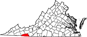 Map of Virginia highlighting Grayson County | |
| CDPs | ||
| Other communities | ||
| Footnotes | ‡This populated place also has portions in an adjacent county or counties | |
This article is issued from Wikipedia. The text is licensed under Creative Commons - Attribution - Sharealike. Additional terms may apply for the media files.