Suffolk Downs station
Suffolk Downs station is a rapid transit station on the Massachusetts Bay Transportation Authority (MBTA) Blue Line, located on the east side of Orient Heights in East Boston, Massachusetts, United States. It is named for the now-defunct Suffolk Downs racetrack, located just to the north. Suffolk Downs station has two side platforms, with a footbridge structure of brick, concrete, and steel connecting them. The station is accessible. With just 521 daily boardings in FY 2019, Suffolk Downs is the least-used fare-controlled station on the MBTA subway system.
Suffolk Downs | |||||||||||
|---|---|---|---|---|---|---|---|---|---|---|---|
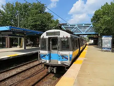 An outbound train at Suffolk Downs station in 2018 | |||||||||||
| General information | |||||||||||
| Location | 1230 Bennington Street[1] East Boston, Massachusetts, US | ||||||||||
| Coordinates | 42.3904°N 70.9970°W | ||||||||||
| Line(s) | Revere Extension | ||||||||||
| Platforms | 2 side platforms | ||||||||||
| Tracks | 2 | ||||||||||
| Construction | |||||||||||
| Structure type | At grade | ||||||||||
| Parking | 108 spaces ($2.50 fee)[1] | ||||||||||
| Bicycle facilities | Racks available[1] | ||||||||||
| Accessible | Yes | ||||||||||
| History | |||||||||||
| Opened | April 21, 1952 | ||||||||||
| Rebuilt | September 17, 1982–January 3, 1984 June 25, 1994–June 24, 1995 | ||||||||||
| Passengers | |||||||||||
| FY2019 | 521 boardings (weekday average)[2] | ||||||||||
| Services | |||||||||||
| |||||||||||
| Location | |||||||||||
Two previous stations at the site were operated by the Boston, Revere Beach and Lynn Railroad, which opened through East Boston in 1875. The railroad opened Waldemar station in 1894 to serve a nearby development; it was soon renamed Belle Isle. The station closed in the 1920s, but a new station named Suffolk Downs station opened on the site in 1935 to serve the new racetrack. Service on the line ended in 1940. Electric streetcar service on a parallel line operated from 1893 to 1952; a spur line directly to the racetrack was operated from 1935 to 1952.
The Metropolitan Transportation Authority (MTA) purchased the abandoned right-of-way in 1941 to extend the East Boston Tunnel rapid transit line. The MTA opened its Suffolk Downs station with a single platform in 1952; it was expanded with a second platform in 1954 as part of the second phase of the Revere Extension. After a 1976 fire, only the inbound platform remained open until a 1982–1984 renovation. The station was renovated further in 1994–95, and further improvements are planned as part of a redevelopment of the racetrack site.
Station design
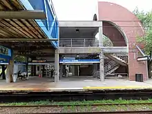
Suffolk Downs station is located at the east end of the Orient Heights neighborhood in East Boston.[3] The defunct Suffolk Downs racetrack is to the north, and Belle Isle Marsh Reservation to the south and east.[4] The surface-level station has two side platforms serving the two tracks of the Blue Line.[5]
The dominant architectural form of the station is the symmetrical footbridge structure designed by architect Eduardo Lozano.[6]: 77 The structure has a hierarchy of three materials: "neutral" concrete supports the footbridge and provides shelter for passengers, warmer brick covers exterior faces and some interior walls, and the blue-painted steel footbridge "echoes the metallic technology of the railroad".[6]: 78 The bridge is divided into separate paid and unpaid corridors; both halves have ramps (but no elevators) for accessibility, while the paid half also has stairs to the platforms.[7][6]: 77
The station was designed as a "transparent fortress", as the MBTA's primary design consideration was security.[6]: 77 Open forms provide cover for passengers, but allow the single station agent or a police officer outside to surveil the whole station. The architect called it "a proxy for a building".[6]: 77 The design was inspired by medieval fortified churches, with battered walls to discourage climbing and iron palisades to separate paid and unpaid areas.[6]: 77 The brick arches were partially medieval in design – and partially just the architect's preference.[6]: 77
The station has entrances from Bennington Street and Walley Street. Due to low ridership, there are only faregates on the Walley Street (inbound) side; the outbound side only has a high exit turnstile. Passengers must use the unpaid portion of the footbridge to enter from Bennington Street, and the paid portion to reach the outbound platform.[8] A 108-space parking lot is located on the Bennington Street side north of the entrance.[1][3]
History
BRB&L and streetcars
The narrow gauge Boston, Revere Beach and Lynn Railroad (BRB&L) opened from East Boston to Lynn through Breed's Hill (later part of East Boston) on July 29, 1875; there was initially no station between Winthrop and Beachmont.[9] Waldemar station opened in 1894 to serve a new housing development on Orient Heights.[10][11][12]: 102 It was renamed Belle Isle within several years.[13][14] The development failed in 1907, but the station remained open.[12]: 102 The station closed in the mid-1920s.[15][16][17] The wooden structure suffered a number of fires in 1925 and 1926 caused by sparks from passing locomotives.[18][15]
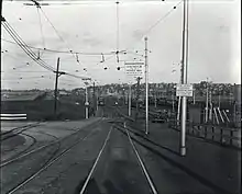
On July 4, 1889, the Boston and Revere Electric Street Railway opened a new electric streetcar line from Winthrop Junction to Crescent Beach, running on a private right-of-way that paralleled the BRB&L tracks on the north side. It was initially only used for seasonal service to the Great Ocean Pier, which closed in 1893; the Lynn and Boston Street Railway began operating the line full-time on July 17, 1893.[19]: 229 The line passed through several successor companies; by the 1930s, the Eastern Massachusetts Street Railway and the Boston Elevated Railway (BERy) jointly operated Maverick–Revere Beach through service.[19]: 231 In 1930, the BERy constructed a small yard, Gladstone Loop, north of Waldemar Avenue near the former Belle Isle station. It served as the terminal for Maverick–Gladstone Loop short turns and had a small shelter for inbound passengers.[20]: 29
In 1928, the BRB&L was electrified with pre-pay stations, making it more like a rapid transit line than a conventional railroad.[17] A new station, Suffolk Downs, was built at the former Belle Isle site when the horse-racing track opened in July 1935. The Boston Elevated Railway also opened a streetcar spur from Gladstone Loop to the track.[21] On June 10, 1936, the Eastern Massachusetts Street Railway sold its remaining streetcar lines in Chelsea, Everett, and Revere to the BERy.[19]: 230 Due to the Great Depression, the BRB&L shut down on January 27, 1940.[22] Suffolk Downs station was sold to a private owner after the closure.[12]: 102
Rapid transit
In 1941, the Boston Elevated Railway bought the BRB&L right of way from Day Square to Revere Beach for use as a high-speed streetcar line similar to the Ashmont-Mattapan High Speed Line. These plans were delayed by the onset of World War II.[12]: 8 However, the 1926 Report on Improved Transportation Facilities and 1945–47 Coolidge Commission Report recommended that the East Boston Tunnel line, which had been converted to rapid transit from streetcars in 1924, be extended to Lynn via the BRB&L right-of-way, rather than using the right-of-way for a streetcar line.[23][24]
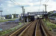
In 1947, the newly formed Metropolitan Transit Authority (MTA) decided to build the extension to Lynn as a rapid transit line. Construction began in October 1948.[12]: 8 The first part of the Revere Extension opened to Orient Heights on January 5, 1952. The remaining streetcar lines in East Boston, Chelsea, and Revere were replaced with trackless trolleys at that time. The new Orient Heights–Revere Beach Loop line ran on Bennington Street south of the former BRB&L alignment. There was no replacement for the Suffolk Downs streetcar spur.[20]
A one-stop rapid transit extension to Suffolk Downs station opened on April 21, 1952 – the first day of the racing season. The station initially had only one track and one platform, and was only open during the racing season.[25][12]: 103 A rapid transit spur directly to the racetrack was considered, but was rejected due to cost.[12]: 104 However, the MTA reactivated the Suffolk Downs spur, running a streetcar shuttle to the track until the racing season ended on June 28. This shuttle was not resumed for the 1953 season.[20]: 31 Most of the streetcar trackage was later removed, though the switches to the Suffolk Downs spur and a short segment on Walley Street remains extant.[20]: 29 The former BRB&L station was demolished in May 1952.[12]: 104
The second phase of the Revere Extension (cut short due to limited funds) opened to Wonderland on June 19, 1954, with a second track and platform added to Suffolk Downs station for full-time service.[25][26][12]: 103 Because Suffolk Downs station was expected to be used primarily during the short racing season, the platforms were constructed of wood rather than the concrete used in the other stations.[12]: 104 The Orient Heights–Revere Beach trackless trolley line was rendered redundant by the extension to Wonderland and was discontinued on June 18, 1955, ending bus service to the station.[19]: 231 The Massachusetts Bay Transportation Authority (MBTA) replaced the MTA in August 1964. The subway lines were given colored identifying names in 1965, with the East Boston Tunnel route becoming the Blue Line.[26]
Renovations
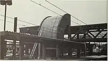
A fire on February 14, 1976 destroyed much of the wooden station.[27] Only the inbound platform remained open after the fire, which hurt attendance at races.[26][28] From February 1 to December 16, 1981, Sunday service between Orient Heights and Wonderland was replaced by shuttle buses due to budget cuts.[26] The MBTA received a $1.9 million grant from the Urban Mass Transportation Administration to fund a new station, and a $2.5 million construction contract was awarded on August 27, 1982.[28][29] Construction began on September 17, but was soon suspended until March 1983 due to winter conditions.[30] The station closed for reconstruction in 1983, and the new station fully opened on January 3, 1984.[31] It was designed for security and easy surveillance, with nonflammable materials to avoid a repeat of the 1976 fire.[6]: 77 Suffolk Downs was the first accessible station on the Blue Line, and the only accessible station on the line until renovations to State finished in 1987.[26][7][32]
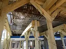
The station was closed for one year starting on June 25, 1994 as Suffolk Downs, Beachmont, Revere Beach, and Wonderland stations were rebuilt as part of the Blue Line Modernization Program. Blue Line service temporarily ended at Orient Heights and buses served the closed outer stations during the project.[26][33] Because Suffolk Downs station had been completely rebuilt just a decade before, it needed just $3 million worth of work, compared to $9 million each at Revere Beach and Wonderland and $27 million for a completely new station at Beachmont.[34] The inbound platform was extended 100 feet (30 m) to the south, and the outbound platform an equal length to the north.[35] The stations reopened on June 24, 1995.[34]
Unlike most MBTA rapid transit stations, Suffolk Downs has no direct MBTA bus connections; the nearest route is the 120 about 700 feet (210 m) to the southwest.[36] However, during the 2013 reconstruction and closure of Orient Heights, Suffolk Downs was used as the terminus of replacement shuttle bus service.[26] The footbridge was closed on March 22, 2021, due to structural deterioration, but the station remained open. Passengers needing to cross between platforms had to take a train one stop to Orient Heights or Beachmont.[37] The footbridge deck was replaced during a closure of the outer portion of the Blue Line from May 22 to June 8, 2022.[38] The footbridge reopened in October 2022.[39]
Averaging just 521 daily boardings in FY 2019, Suffolk Downs is the least-used fare-controlled station on the MBTA subway system.[2] The redevelopment of the Suffolk Downs site is expected to substantially increase ridership to Suffolk Downs and Beachmont stations. The developer, HYM Investment Group, has committed $20 million for transit projects including modifications to both stations.[40][41] Reconstruction of the station is expected to begin between FY 2023 and FY 2027.[42] Conceptual design began in mid-2022.[43]
References
- "Suffolk Downs". Massachusetts Bay Transportation Agency. Retrieved April 27, 2021.
- "A Guide to Ridership Data". MassDOT/MBTA Office of Performance Management and Innovation. June 22, 2020. p. 8.
- "Neighborhood of East Boston". Boston Planning and Development Agency. November 2016.
- "Suffolk Downs Station Neighborhood Map" (PDF). Massachusetts Bay Transportation Authority. July 2010.
- "Ridership and Service Statistics" (PDF) (14th ed.). Massachusetts Bay Transportation Authority. 2014.
- Brenner, Douglas (January 1987). "In transit" (PDF). Architectural Record. pp. 67–83.
- TranSystems and Planners Collaborative (August 24, 2007). "Evaluation of MBTA Paratransit and Accessible Fixed Route Transit Services: Final Report" (PDF). Massachusetts Bay Transportation Agency. p. 189.
- Cox, Jeremiah (July 2, 2011). "Suffolk Downs". The SubwayNut. Retrieved April 11, 2021.
- Bradlee, Francis Boardman Crowninshield (1921). The Boston, Revere Beach and Lynn Narrow Gauge Railroad. Essex Institute. pp. 4–5 – via Google Books.
- "Real Estate". Boston Globe. June 3, 1894. p. 10 – via Newspapers.com.
- "Crowds Increase [Advertisement]". Boston Globe. June 7, 1894. p. 5 – via Newspapers.com.
- Cheney, Frank (2003). Boston's Blue Line. Arcadia Publishing. ISBN 9780738535760.
- "Streets of Beachmont Blocked". Boston Globe. February 14, 1899. p. 3 – via Newspapers.com.
- Bromley, George W.; Bromley, Walter S. (1901). "Plate 30". Atlas of the city of Boston : East Boston : from actual surveys and official plans. G.W. Bromley & Co.
- "East Boston District". Boston Daily Globe. August 2, 1926. p. A10 – via Newspapers.com.
- "East Boston District". Boston Globe. July 23, 1924. p. 10 – via Newspapers.com.
- ""Narrow Gage" Electrified for Economy". Electric Railway Journal. 72 (23): 991–998. December 8, 1928 – via Internet Archive.
- "East Boston District". Boston Daily Globe. August 26, 1925. p. A11 – via Newspapers.com.
- Humphrey, Thomas J. (August 2020). "Origin and Development of the Fixed-Route Local Bus Transportation Network in the Cities and Towns of the Massachusetts Bay Transportation Authority District as of December 31, 1973: Revised Edition" (PDF). NETransit.
- Clarke, Bradley H. (2015). Streetcar Lines of the Hub: Boston's MTA Through Riverside and Beyond. Boston Street Railway Association. ISBN 9780938315070.
- "Modern Magic Has Transformed Dumping Ground Into Suffolk Downs, One of Country's Finest Race Tracks". Boston Globe. July 6, 1935. p. 3 – via Newspapers.com.
- Karr, Ronald Dale (1995). The Rail Lines of Southern New England. Branch Line Press. pp. 268–272. ISBN 0942147022.
- Central Transportation Planning Staff (November 15, 1993). "The Transportation Plan for the Boston Region - Volume 2". National Transportation Library. Archived from the original on October 5, 2013.
- Boston Elevated Railway and Boston Department of Public Utilities (1945), Boston Rapid Transit System & Proposed Extensions 1945 - Metropolitan Transit Recess Commission Air View – via Wikimedia Commons
- "Rapid Transit Line to Revere to Open June 19". Boston Globe. June 9, 1954. p. 9 – via Newspapers.com.
- Belcher, Jonathan. "Changes to Transit Service in the MBTA district" (PDF). Boston Street Railway Association.
- "Fire damages MBTA station". Boston Globe. February 15, 1976. p. 42 – via Newspapers.com.
- Temple, Robert (2009). The Pilgrims Would Be Shocked: The History of Thoroughbred Racing in New England. Robert Temple. ISBN 978-1-4415-1428-8.
- 1982 Annual Report. Massachusetts Bay Transportation Authority. 1983. p. 25 – via Internet Archive.
- "Ask The Globe". Boston Globe. February 14, 1983. p. 43 – via Newspapers.com.
- "Suffolk Downs station open". Boston Globe. January 4, 1984. p. 21 – via Newspapers.com.
- 1986 Annual Report. Massachusetts Bay Transportation Authority. 1986. p. 23 – via Internet Archive.
- Blake, Andrew (March 20, 1994). "MBTA to begin $467 million Blue Line project". Boston Globe – via Newspapers.com. (second page)

- Blake, Andrew (June 18, 1995). "Blue Line stations set to reopen after $467m upgrade". Boston Globe – via Newspapers.com. (second page)

- Fay, Spofford & Thorndike (October 1993). Blue Line Station Modernization Project Final Environmental Impact Report. Massachusetts Bay Transportation Authority. p. 1-4.
- "System Map". Massachusetts Bay Transportation Authority. Retrieved July 31, 2023.
- "Alerts: Subway". Massachusetts Bay Transportation Authority. March 22, 2021. Archived from the original on March 23, 2021.
- "Work Completed on Pedestrian Bridge at Suffolk Downs Station" (Press release). Massachusetts Bay Transportation Authority. June 9, 2022.
- "Suffolk Downs Pedestrian Bridge". Massachusetts Bay Transportation Authority. October 2022. Archived from the original on November 1, 2022.
- HYM Investment Group (September 16, 2019). "Suffolk Downs Redevelopment: Additional Information Document". Boston Planning and Development Authority. p. 14.
- "Suffolk Downs Redevelopment: Boston Zoning Commission Hearing". Boston Planning and Development Authority. October 21, 2020. p. 29.
- "Massachusetts Bay Transportation Authority FY23-27 Capital Investment Plan (CIP): Proposed" (PDF). Massachusetts Bay Transportation Authority. March 2022. p. 38.
- "Suffolk Downs Station Improvements". Massachusetts Bay Transportation Authority. Archived from the original on October 18, 2022.
External links
- MBTA - Suffolk Downs
- MBTA – Suffolk Downs Station Improvements
- Google Maps Street View: Bennington Street entrance, Walley Street entrance