Sugar Land Regional Airport
Sugar Land Regional Airport (IATA: SGR, ICAO: KSGR, FAA LID: SGR) is a city-owned public-use airport located in Sugar Land, Texas (USA), 17 miles (27 km) southwest of the central business district of Houston.[1][2]
Sugar Land Regional Airport | |||||||||||
|---|---|---|---|---|---|---|---|---|---|---|---|
 | |||||||||||
| Summary | |||||||||||
| Airport type | Public | ||||||||||
| Owner | City of Sugar Land | ||||||||||
| Serves | Houston–Sugar Land–Baytown | ||||||||||
| Location | Sugar Land, Texas (USA) | ||||||||||
| Elevation AMSL | 81 ft / 25 m | ||||||||||
| Coordinates | 29°37′20″N 095°39′24″W | ||||||||||
| Website | www.FlySGR.com | ||||||||||
| Map | |||||||||||
 SGR Location of airport in Texas / United States  SGR SGR (the United States) | |||||||||||
| Runways | |||||||||||
| |||||||||||
| Statistics (2023) | |||||||||||
| |||||||||||
Founded privately in the early 1950s as Hull Field, it was renamed in 1990, as Sugar Land Municipal Airport when acquired by the city. As of 2009 it is the fourth-largest airport within the Houston–Sugar Land–Baytown metropolitan area and serves as a "reliever" of traffic to this airport. It handles approximately 200 aircraft operations per day during typical years, which include corporate business jet and turboprop flights.
The airport today serves the area's general aviation (GA) aircraft, serving corporate, governmental, and private clientele. It opened a new 20,000-square-foot (1,900 m2) Terminal in 2006 with a 54-acre (22 ha) GA complex, including 99 T-hangars in six buildings.[3]
The City of Sugar Land maintains Cullinan Park, which occupies 750 acres (300 ha) of land directly north and west of the Sugar Land Regional Airport, blocking expansion. The airport is surrounded by Sugar Land homes, and there is a highway and rail road track directly south of the airport, which also block its expansion. The former Central Unit, a Texas Department of Criminal Justice prison for males, was closed in 2011. It occupied land zoned for airport expansion.[4]
History
Dr. Donald "Doc" Hull was an oral surgeon who established a dental program for the Texas Department of Corrections in the early 1950s. Hull, who commuted across Southeast Texas to provide dental care to prisoners, originally operated aircraft to South Houston Airport and Sam Houston Airport. As it expanded, the City of Houston forced those airports to close. The former Sam Houston Airport was annexed as part of Houston's extraterritorial jurisdiction (ETJ) and became the Westbury area.
Hull decided to develop a regional airport more distant from Houston but to serve the area. In 1952, Hull landed his biplane in a field near Sugar Land. Afterward, with a loan from a friend, Hull purchased the property and developed a small airport.[5]
The City of Sugar Land purchased Hull Field on December 18, 1990, and renamed the airport as "Sugar Land Municipal Airport."[5] The City of Sugar Land opened an NFCT (non-federal control tower) that it funds and operates. This control tower manages traffic within 4 miles (6 km) of Sugar Land Airport from 6:00 a.m. to 10:00 p.m. daily.[2]
Past airline service
Several commuter airlines operated scheduled passenger service into Sugar Land Regional over the years. In the fall of 1979, Commutair was flying a "cross-town" shuttle service between the airport and Houston Intercontinental Airport (IAH), with de Havilland Canada DHC-6 Twin Otter twin turboprop aircraft operating up to twelve round-trip flights a day.[6]
The Commutair service was replaced by Metro Airlines during the 1980s. In the summer of 1983, Metro, operating as an independent air carrier, was flying up to nine round trips a day between Sugar Land and Houston Intercontinental with Twin Otter aircraft.[7] By early 1985, Metro Airlines had entered into a codesharing agreement with Eastern Air Lines and was flying Twin Otter aircraft as Eastern Express between the airport and IAH with up to eleven round trip flights a day.[8]
In 1993, Austin-based Conquest Airlines announced it would begin intrastate flights from the airport to Austin (Mueller Airport), Dallas Love Field (DAL), and San Antonio.[9] By 1994, Conquest had dropped flights to San Antonio but was still operating nonstops to Austin and Dallas.[10] In 1995, the airline was operating three nonstop flights a day to Austin with Fairchild Swearingen Metroliner (Metro III model) propjets. By 1996, Conquest was no longer serving Sugar Land Regional.[11]
The airport does not have any scheduled passenger airline flights at the present time.
Current name
Sugar Land Regional Airport received its current name in October 2002.[5] The airfield was formerly known as Sugar Land Municipal Airport and Hull Field. It is the fourth-largest airport in Greater Houston as of 2009, receiving annual usage from private planes of more than 100 Fortune 500 companies. TXP, Inc. released a report identifying the airport as "foremost general reliever airport in the southwest sector" and "a catalyst for corporate commerce in the Greater Houston market including the Westchase District, Uptown, and Greenway Plaza."[12]
The airport is the fourth-largest in the Houston area, serving as a reliever for William P. Hobby Airport. As of 2010, Sugar Land Regional is the third-busiest airport in Greater Houston by number of aircraft operations.[13]
Facilities and aircraft

Sugar Land Regional Airport covers an area of 622 acres (252 ha) and contains one concrete paved runway designated 17/35 which measures 8,000 x 100 ft (2,438 x 30 m). For the 12-month period ending February 28, 2023, the airport had 43,973 aircraft operations, an average of 120 per day: 99% general aviation, and less than 1% military. In February 2023, there were 162 aircraft based at this airport: 104 single-engine, 16 multi-engine, 39 jet and 3 helicopter.[2]
The airport includes the former Stanford Aviation hangar, described by Mimi Swartz of Texas Monthly as "impeccably landscaped." Flights from the terminal went to Antigua.[14]
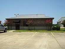
US Customs and Border Protection has a small facility at the airport.
Gallery
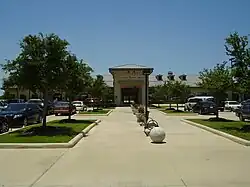
 Stanford Aviation Terminal
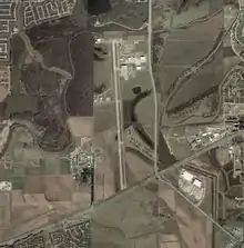
 Aerial photograph of the airport and the Central Unit prison property, which is on both sides of the runway, on January 27, 2002 - U.S. Geological Survey
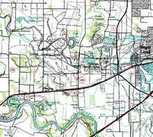
 Topographical map of the airport, with the Central Prison Farm. To the west is the Jester Prison Farm (Jester I, Jester II (Carol Vance), Jester III, and Jester IV), July 1, 1990, U.S. Geological Survey
References
- Sugar Land Regional Airport, official web site
- FAA Airport Form 5010 for SGR PDF, effective August 10, 2023.
- Kanable, Rebecca (May–June 2011). "Sugar Land Regional". Airport Improvement Magazine. Retrieved 2011-05-28.
- Pina, Kim (April 18, 2008). "What's in store for Sugar Land's airport?". Houston Chronicle. Retrieved June 13, 2009.
- "History". Sugar Land Regional Airport. Archived from the original on February 10, 2008. Retrieved August 18, 2010. ()
- http://www.departedflights.com, Nov. 15, 1979 Official Airline Guide (OAG), Houston (IAH) schedules
- http://www.departedflights.com, July 1, 1983 Official Airline Guide (OAG), Houston (IAH) schedules
- http://www.departedflights.com, Feb. 15, 1985 Official Airline Guide (OAG), Houston (IAH) schedules
- Staff (October 14, 1993). "Conquest Airlines to add 21 flights to Sugar Land schedule". Austin American-Statesman. pp. F1. Retrieved June 13, 2009.
- http://www.departedflights.com, Sept. 15, 1994 Conquest Airlines route map
- April 2, 1995 Offioial Airline Guide (OAG), Austin schedules
- "Potential Economic & Tax Impact of Central Prison Unit & Smithville Property Redevelopment". Feasibility Study of Relocating the Central Unit (PDF). Texas Department of Criminal Justice. January 2009. pp. 1 (24/45). Archived from the original (pdf) on July 5, 2009. Retrieved July 21, 2010.
- Crocker, Ronnie (November 27, 2010). "A lot of lift". Houston Chronicle. Retrieved November 29, 2010.
- Swartz, Mimi (May 2009). "The Dark Knight". Texas Monthly. Vol. 37, no. 5. p. 211.
External links
- Sugar Land Regional Airport
- The Economic Impact of Sugar Land Regional Airport
- Resources for this airport:
- FAA airport information for SGR
- AirNav airport information for KSGR
- ASN accident history for SGR
- FlightAware airport information and live flight tracker
- NOAA/NWS weather observations: current, past three days
- SkyVector aeronautical chart, Terminal Procedures