Sumy Oblast
Sumy Oblast (Ukrainian: Сумська́ о́бласть, romanized: Sumska oblast), also known as Sumshchyna (Су́мщина), is an oblast (province) in northeast Ukraine. The oblast was created in its most recent form, from the merging of raions from Kharkiv Oblast, Chernihiv Oblast, and Poltava Oblast in 1939 by the Presidium of the Supreme Soviet of the Soviet Union.
Sumy Oblast
Сумська область | |
|---|---|
| Sumska oblast[1] | |
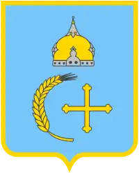 Coat of arms | |
| Nickname: Сумщина (Sumshchyna) | |
 | |
| Country | |
| Administrative center | Sumy |
| Government | |
| • Governor | Volodymyr Artyukh |
| • Oblast council | 64[2] seats |
| • Chairperson | Volodymyr Tokar |
| Area | |
| • Total | 23,834 km2 (9,202 sq mi) |
| • Rank | Ranked 16th |
| Population (2022)[3] | |
| • Total | |
| • Rank | Ranked 19th |
| Gross Regional Product | |
| • Total | ₴ 105 billion (€2.726 billion) |
| • Per capita | ₴ 100,760 (€2,609) |
| Time zone | UTC+2 (EET) |
| • Summer (DST) | UTC+3 (EEST) |
| Postal code | |
| Area code | +380-54 |
| ISO 3166 code | UA-59 |
| Raions | 18 |
| Cities (total) | 15 |
| • Regional cities | 7 |
| Urban-type settlements | 20 |
| Villages | 1492 |
| FIPS 10-4 | UP21 |
| Website | sorada.gov.ua |

The estimated population is 1,035,772 (2022 estimate).[3]
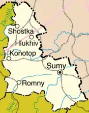
The administrative center of the oblast is the city of Sumy. Other important cities within the oblast include Konotop, Okhtyrka, Romny, and Shostka. The oblast has a heavy mix of agriculture and industry, with over 600 industrial locations. Importantly, seven rivers pass through the oblast.
Geography
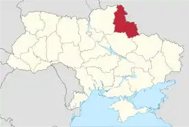
The Sumy Oblast is situated in the northeastern part of Ukraine. It is situated on a border of two historical regions of Ukraine — Cossack Hetmanate (annexed by Russia in the 18th century as Little Russia, previously known as Severia) and Sloboda Ukraine. Elevation is 110–240m above sea level.[5] The area of the oblast (23,800 km2), comprises about 3.95% of the total area of the country.
The oblast borders Bryansk Oblast (Russia) on the northeast, Belgorod Oblast and Kursk Oblast (Russia) on the east, Poltava Oblast on the southwest, Kharkiv Oblast on the south, and the Chernihiv Oblast on the west.
Seven main rivers flow through the oblast, with the Desna River the largest.[5]
The Sumy Oblast contains 168 objects and territories of natural reserve. The oblast is rich in picturesque banks of numerous rivers, and sources of mineral waters. Major environmental problems are: soil erosion, pesticide pollution, air and water pollution. The city has a problem of garbage utilization. The only place for pesticide utilization in Ukraine is Shostka, Sumy region.
History
The region was created on the ukase of Presidium of the Supreme Soviet of the Soviet Union on 10 January 1939 as part of the Ukrainian Soviet Socialist Republic. The newly created Sumy Oblast included 12 former raions of Kharkiv Oblast, 17 former raions of Chernihiv Oblast, and 2 former raions of Poltava Oblast.
During World War II in 1941–43, it was occupied by Nazi Germany under administration of the German Wehrmacht. After the German forces were driven out, the Soviet Union regained control of the region under jurisdiction of the Ukrainian Soviet Socialist Republic.
In 1965 one of former Chernihiv Oblast raions (Talalaivka Raion) was returned to Chernihiv Oblast.
During the 2022 Russian invasion of Ukraine the Sumy Oblast was one of the first regions where Russian and Ukrainian forces clashed.[6][7][8] Parts of the oblast came under Russian occupation during the invasion. On 4 April 2022 Governor of Sumy Oblast Dmytro Zhyvytskyi stated that Russian troops no longer occupied any towns or villages in Sumy Oblast and had mostly withdrawn, while Ukrainian troops were working to push out the remaining units.[9] On 8 April 2022 Zhyvytskyi stated that all Russian troops had left Sumy Oblast.[10]
Points of interest
The following historic-cultural sited were nominated for the Seven Wonders of Ukraine.
- Monument to mamonth (Kulishivka)
- Kruhliy dvir (Round court)
- Sofroniiv monastery
Administrative divisions
It comprises 5 raions (districts) that are further subdivided into 51 territorial hromadas (communities).
The following data incorporates the number of each type of administrative divisions of the Sumy Oblast:
The local administration of the oblast is controlled by the Sumy Oblast council. The governor of the oblast (chairman of state regional administration) is appointed by the President of Ukraine.
Demographics
At the 2001 census, the ethnic groups within the Sumy Oblast were: 88.8% Ukrainians, 9.4% Russians.[11]
Age structure
- 0-14 years: 12.7%
 (male 74,529/female 70,521)
 - 15-64 years: 70.8%
 (male 386,250/female 422,077)
 - 65 years and over: 16.5%
 (male 60,374/female 127,306) (2013 official)
Median age
- total: 42.0 years
- male: 38.6 years
- female: 45.4 years (2013 official)
Economy
Industry
The main industrial activities of the oblast are: chemical mechanical engineering, pumping and energy mechanical engineering, agricultural machine-construction, instrument-making industry and radio electronics, technical equipment production for processing fields of agro-industrial complexes, mining and iron ore production industry, polygraph industry and medicine production, oil and gas processing, chemical production, film and photo material production (See: Svema), and chemical fertilizer production. In general, there are 273 large industry enterprises and 327 small industry enterprises.
Agriculture
In 1999, the gross grain yield was about 446,000 tons, sugar beets – 664,000 tons, sunflower seeds – 27,700 tons, potatoes – 343,600 tons. The region also produced 108,700 tons of meat, 517,800 tons of milk and 295,300,000 eggs. At the beginning of 1999, there were 781 registered farms in the oblast.
Notable people from Sumy Oblast
- Viktor Yushchenko – 3rd President of Ukraine (2005–2010); Khoruzhivka village
- Yevhen Adamtsevych – a Ukrainian bandurist, the author of Zaporizhian March
- Oleksi Berest – one of the soldiers who hoisted the Victory Banner in Berlin and a posthumous Hero of Ukraine.
- Dmitry Chechulin – architect; born Shostka 1901
- Thomas de Hartmann, composer
- Oleh Husyev – Ukrainian internal footballer
- Ivan Nikitovich Kozhedub – WW2 ace and air marshal of the Soviet Union.
- Natalia Ivanovna Sedova – Wife of Leon Trotsky, born Romny 1882
- Stephen Timoshenko – the father of modern engineering mechanics (1878-1972)
- Leonid Toptunov – senior reactor control chief engineer at the Chernobyl Nuclear Power Plant Reactor Unit 4 on the night of the Chernobyl disaster
Nomenclature
Most of Ukraine's oblasts are named after their capital cities, officially referred to as "oblast centers" (Ukrainian: обласний центр, translit. oblasnyi tsentr). The name of each oblast is a relative adjective, formed by adding a feminine suffix to the name of respective center city: Sumy is the center of the Sums’ka oblast (Sumy Oblast). Most oblasts are also sometimes referred to in a feminine noun form, following the convention of traditional regional place names, ending with the suffix "-shchyna", as is the case with the Sumy Oblast, Sumshchyna.
References
- Syvak, Nina; Ponomarenko, Valerii; Khodzinska, Olha; Lakeichuk, Iryna (2011). Veklych, Lesia (ed.). Toponymic Guidelines for Map and Other Editors for International Use (PDF). p. 20. ISBN 978-966-475-839-7. Retrieved 6 October 2020.
{{cite book}}:|website=ignored (help) - (in Ukrainian) List of members of the Sumy Regional Council of the Sixth Convocation Archived 1 October 2020 at the Wayback Machine, Official website Sumy Parliament
- Чисельність наявного населення України на 1 січня 2022 [Number of Present Population of Ukraine, as of January 1, 2022] (PDF) (in Ukrainian and English). Kyiv: State Statistics Service of Ukraine. Archived (PDF) from the original on 4 July 2022.
- "Валовии регіональнии продукт".
- "ІNVESTMENT PASSPORT of Sumy oblast- STATE AGENCY FOR INVESTMENT AND NATIONAL PROJECTS OF UKRAINE" (PDF). 2013. Archived from the original (PDF) on 13 August 2014. Retrieved 12 August 2014.
- "Украинские пограничники сообщили об атаке границы со стороны России и Белоруссии". Interfax. 24 February 2022. Archived from the original on 24 February 2022. Retrieved 24 February 2022.
- "Войска России на севере Украины продвинулись вглубь до пяти километров – Арестович". Archived from the original on 24 February 2022. Retrieved 24 February 2022.
- "Перші три дні повномасштабної російсько-української війни (текстовий онлайн) | Громадське телебачення". Hromadske (in Ukrainian). 24 February 2022. Archived from the original on 24 February 2022. Retrieved 24 February 2022.
- Russian troops no longer hold any settlements in Ukraine's Sumy region, says governor, National Post (4 April 2022)
- Sumy region liberated from Russian troops, Ukrayinska Pravda (8 April 2022)
- "Results of the population census of Ukraine in 2001". Demoscope Weekly.
External links
- State Administration of Sumy Oblast – official site (in Ukrainian)
- Information Card of the Region – official site of the Cabinet of Ministers of Ukraine
- Independent regional Web-portal – news, features, entertainment & tourism info (in Ukrainian)