Sunderlandwick
Sunderlandwick is a hamlet in the East Riding of Yorkshire, England. It is situated approximately 1.5 miles (2.4 km) south of Driffield and lies to the west of the A164 road.
| Sunderlandwick | |
|---|---|
 Sunderlandwick Location within the East Riding of Yorkshire | |
| OS grid reference | TA015555 |
| Civil parish | |
| Unitary authority | |
| Ceremonial county | |
| Region | |
| Country | England |
| Sovereign state | United Kingdom |
| Post town | DRIFFIELD |
| Postcode district | YO25 |
| Dialling code | 01377 |
| Police | Humberside |
| Fire | Humberside |
| Ambulance | Yorkshire |
| UK Parliament | |
It forms part of the civil parish of Hutton Cranswick.
Sunderlandwick House and its associated stables was designated a Grade II listed building on 15 July 1998.[1][2]
Driffield Golf Club is actually in Sunderlandwick despite the name.[3]
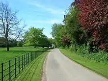
Drive to Sunderlandwick House ( 53°59'6.23"N 0°26'58.08"W ). The house was built in 1962–63 for Sir Thomas Ferens on the site of an earlier Georgian house, Sunderlandwick Hall, altered in 1840s and burnt down on VJ Day, 1945.
References
- Historic England. "Sunderlandwick House (1375668)". National Heritage List for England. Retrieved 15 June 2016.
- Historic England. "Stables at Sunderlandwick House (1375669)". National Heritage List for England. Retrieved 15 June 2016.
- "Welcome". Driffield Golf Club. Retrieved 13 July 2010.
- Gazetteer — A–Z of Towns Villages and Hamlets. East Riding of Yorkshire Council. 2006. p. 10.
External links
Wikimedia Commons has media related to Sunderlandwick.
- Sunderlandwick in the Domesday Book
| Unitary authorities | |
|---|---|
| Major settlements (cities in italics) | |
| Rivers | |
| Canals | |
| Topics | |
This article is issued from Wikipedia. The text is licensed under Creative Commons - Attribution - Sharealike. Additional terms may apply for the media files.