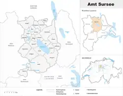
Sursee District
Sursee District is one of the five Ämtern, or districts, of the German-speaking Canton of Lucerne, Switzerland. Its capital is the town of Sursee. It has a population of 76,451 (as of 31 December 2020). In 2013 the name was changed from Amt Sursee to Wahlkreis Sursee as part of a reorganization of the Canton. A sixth Wahlkreis was created, but in Sursee everything else remained essentially unchanged.
Sursee District
Wahlkreis Sursee | |
|---|---|
District | |
 | |
| Country | |
| Canton | |
| Capital | Sursee |
| Area | |
| • Total | 287.74 km2 (111.10 sq mi) |
| Population (2020) | |
| • Total | 76,451 |
| • Density | 270/km2 (690/sq mi) |
| Time zone | UTC+1 (CET) |
| • Summer (DST) | UTC+2 (CEST) |
| Municipalities | 19 |
Sursee District consists of the following municipalities:
| Municipality | Population (31 December 2020)[1] |
Area, km² |
|---|---|---|
| Beromünster | 6,661 | 42.12 |
| Büron | 2,662 | 5.37 |
| Buttisholz | 3,322 | 16.71 |
| Eich | 1,600 | 9.22 |
| Geuensee | 2,882 | 6.47 |
| Grosswangen | 3,293 | 19.70 |
| Hildisrieden | 2,437 | 7.04 |
| Knutwil | 2,271 | 9.74 |
| Mauensee | 1,489 | 45.10 |
| Neuenkirch | 7,174 | 26.25 |
| Nottwil | 4,048 | 14.83 |
| Oberkirch | 4,937 | 9.10 |
| Rickenbach | 3,458 | 11.85 |
| Ruswil | 7,041 | 45.3 |
| Schenkon | 3,040 | 6.8 |
| Schlierbach | 925 | 7.2 |
| Sempach | 4,234 | 8.95 |
| Sursee | 10,361 | 5.9 |
| Triengen | 4,616 | 22.08 |
| Total | 72,373 | 287.74[2]a |
- ^a 1992/97 survey gives a total area of 287.50 km2 (111.00 sq mi) without including certain large lakes, while the 2000 survey includes lakes and gives the higher value.
Mergers and name changes
- On 1 January 2004 the former municipality of Schwarzenbach merged into the municipality of Beromünster.[3]
- On 1 January 2009 the former municipality of Gunzwil merged into the municipality of Beromünster.
- On 1 January 2013 the former municipality of Neudorf merged into the municipality of Beromünster and the former municipality of Pfeffikon merged into the municipality of Rickenbach. The municipality of Wolhusen moved from the Sursee District to the Entlebuch District.[3]
References
- "Ständige und nichtständige Wohnbevölkerung nach institutionellen Gliederungen, Geburtsort und Staatsangehörigkeit". bfs.admin.ch (in German). Swiss Federal Statistical Office - STAT-TAB. 31 December 2020. Retrieved 21 September 2021.
- LUSTAT-Canton of Lucerne Statistical Office as of 2000 survey, (in German) accessed 25 August 2009
- Nomenklaturen – Amtliches Gemeindeverzeichnis der Schweiz Archived 2015-11-13 at the Wayback Machine (in German) accessed 9 February 2013
This article is issued from Wikipedia. The text is licensed under Creative Commons - Attribution - Sharealike. Additional terms may apply for the media files.