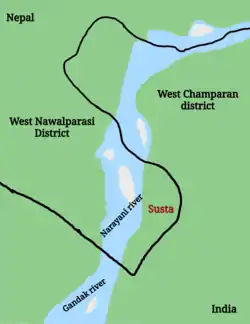
Susta territory
Susta is a disputed territory between Nepal and India. It is administered by India as part of West Champaran district of Bihar. It is claimed by Nepal as part of Susta rural municipality, under West Nawalparasi District in Lumbini Province. The disputed territory is located on the eastern side of the Gandak river (Narayani River in Nepal). Nepal claims the area a part of West Nawalparasi District under Susta rural municipality (part of ward no. 5), alleging that over 14,860 hectares of Nepali land in Susta has been encroached upon by India while India claims "Susta" to be a part of West Champaran district.
Susta | |
|---|---|
Disputed territory | |
 Disputed Susta | |
 Susta Location in Bihar | |
| Coordinates: 27.3572647°N 83.87609°E | |
| Status | Controlled by India Claimed by Nepal |
| Established | Rana regime |
| Founded by | Rana |
| Government | |
| • Type | Ward commissioner |
| • Body | Ward No. 5 |
| Area | |
| • Total | 50 km2 (20 sq mi) |
| Time zone | UTC+5:45 |
According to the Sugauli Treaty signed between British East India Company and Nepal in 1816, the Gandak river is the international boundary and eastern part of the river belongs to India and western part of the river belongs to Nepal. At the time the treaty was signed Susta village was situated west of the river. But, over the years, the Gandak river changed its course and Susta moved to the east side of the river, that is now on the Indian side of the river.
Nepal maintains the Gandak's course in 1816 to be taken as the fixed international boundary but India claims that land on the eastern side of the river is its own territory.[1][2][3]
_1860_Sheet_No._5_Rough_Thak_Bust_Map_of_Boundary_between_Nepal_and_British_Territory.jpg.webp)
References
- "As a river changed its course, a village on the India-Nepal border became disputed territory". www.scroll.in. 19 March 2017. Retrieved 17 August 2018.
- "India and Nepal Tackle Border Disputes". www.thediplomat.com. 22 September 2014. Retrieved 17 August 2018.
- "Change of Course". www.lensculture.com. Retrieved 17 August 2018.