Töging am Inn
Töging am Inn is a town of 9,382 inhabitants in the district of Altötting, Upper Bavaria, Germany. It lies on the river Inn.
Töging am Inn | |
|---|---|
.png.webp) Town hall | |
 Coat of arms | |
Location of Töging am Inn within Altötting district 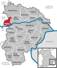 | |
 Töging am Inn  Töging am Inn | |
| Coordinates: 48°15′N 12°34′E | |
| Country | Germany |
| State | Bavaria |
| Admin. region | Oberbayern |
| District | Altötting |
| Subdivisions | 9 Gemeindeteile |
| Government | |
| • Mayor (2020–26) | Tobias Windhorst[1] (CSU) |
| Area | |
| • Total | 13.66 km2 (5.27 sq mi) |
| Elevation | 398 m (1,306 ft) |
| Population (2022-12-31)[2] | |
| • Total | 9,465 |
| • Density | 690/km2 (1,800/sq mi) |
| Time zone | UTC+01:00 (CET) |
| • Summer (DST) | UTC+02:00 (CEST) |
| Postal codes | 84513 |
| Dialling codes | 08631 |
| Vehicle registration | AÖ |
| Website | www.toeging.de |
History
Thanks to an artificial water canal, the town is adjacent to a large water power plant, which used to power e.g. an aluminum furnace. Because of many factories in the area, slave workers from the Dachau concentration camp were located nearby during World War II,.[3]
The town hit the news on 7 February 2006, when the roof of the local Netto supermarket collapsed. Nobody was hurt in the incident.
References
- Liste der ersten Bürgermeister/Oberbürgermeister in kreisangehörigen Gemeinden, Bayerisches Landesamt für Statistik, accessed 19 July 2021.
- Genesis Online-Datenbank des Bayerischen Landesamtes für Statistik Tabelle 12411-003r Fortschreibung des Bevölkerungsstandes: Gemeinden, Stichtag (Einwohnerzahlen auf Grundlage des Zensus 2011)
- Edward Victor.Alphabetical List of Camps, Subcamps and Other Camps.www.edwardvictor.com/Holocaust/List %20 of % 20 camps.htm
External links
- Official website
 (in German)
Towns and municipalities in Altötting district | ||
|---|---|---|
Coat of Arms of Altötting district | ||
This article is issued from Wikipedia. The text is licensed under Creative Commons - Attribution - Sharealike. Additional terms may apply for the media files.