T9 road (Tanzania)
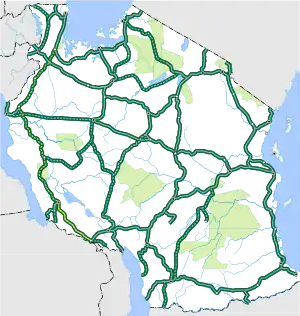
The T9 is a Trunk road in Tanzania. The road runs from Biharamulo in Kagera along the western zones of the country through to Tunduma forming a junction at the Tanzam Highway. The roads as it is approximately 881 km (547 mi). The road is partially paved, with the biggest unpaved section being from Mpanda to Biharamulo.[1][2][3] As of November 2021, the route is the longest unpaved section of the National Trunk road system.
| Trunk Road T9 | ||||
|---|---|---|---|---|
 The T9 is indicated in yellow. | ||||
| Route information | ||||
| Maintained by TANROADS | ||||
| Major junctions | ||||
| North end | T4 in Biharamulo | |||
| T3 in Lusahunga T3 in Nyakanazi T19 in Kasulu T18 in Uvinza T23 in Mpanda T20 in Sumbawanga | ||||
| South end | T1 in Tunduma | |||
| Location | ||||
| Country | Tanzania | |||
| Regions | Kagera, Kigoma, Katavi, Rukwa, Songwe | |||
| Major cities | Biharamulo, Kasulu, Mpanda, Sumbawanga, Tunduma | |||
| Highway system | ||||
| ||||
Route description
Between the 15 km (9.3 mi) stretch from Nyakanazi to Lusahunga, the T9 trunk road shares its designation with the T3 trunk road.
Within Uvinza, there is a 4 km (2.5 mi) stretch of the T9 trunk road that shares its designation with T18 trunk road.
References
- "TANROADS Trunk and Regional Road Map" (PDF). TANROADS. November 2021. Retrieved October 16, 2023.
- "Kagera Trunk and Regional Road Map" (PDF). TANROADS. Retrieved October 17, 2023.
- topschoolsintheusa. "Tanzania Road Network – Top Schools in the USA". Retrieved 2023-10-19.
This article is issued from Wikipedia. The text is licensed under Creative Commons - Attribution - Sharealike. Additional terms may apply for the media files.
