Taipa, Northland
Taipa is a settlement on the southern side of Doubtless Bay in Northland, New Zealand. State Highway 10 runs through it. It is the westernmost of the Taipa-Mangonui string of settlements, and separated from the others by the Taipa River.[3]
Taipa | |
|---|---|
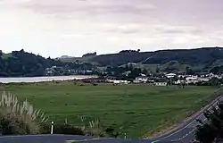 Taipa in 1992 | |
| Coordinates: 34.996°S 173.462°E | |
| Country | New Zealand |
| Region | Northland Region |
| District | Far North District |
| Ward | Te Hiku |
| Electorates | |
| Government | |
| • Territorial Authority | Far North District Council |
| • Regional council | Northland Regional Council |
| Area | |
| • Total | 0.54 km2 (0.21 sq mi) |
| Population (June 2023)[2] | |
| • Total | 180 |
| • Density | 330/km2 (860/sq mi) |
Taipa is traditionally the first landing place of Kupe, the Polynesian explorer of Aotearoa. There is a memorial near the bridge over the Taipa River.[4]
The name may have originated as Taiapa, a fence between two disputed shellfish beds.[4]
Demographics
Statistics New Zealand describes Taipa as a rural settlement. It covers 0.54 km2 (0.21 sq mi)[1] and had an estimated population of 180 as of June 2023,[2] with a population density of 333 people per km2. Taipa is part of the larger Taumarumaru statistical area.[5]
| Year | Pop. | ±% p.a. |
|---|---|---|
| 2006 | 126 | — |
| 2013 | 135 | +0.99% |
| 2018 | 159 | +3.33% |
| Source: [6] | ||
Taipa had a population of 159 at the 2018 New Zealand census, an increase of 24 people (17.8%) since the 2013 census, and an increase of 33 people (26.2%) since the 2006 census. There were 60 households, comprising 75 males and 84 females, giving a sex ratio of 0.89 males per female. The median age was 49.6 years (compared with 37.4 years nationally), with 27 people (17.0%) aged under 15 years, 18 (11.3%) aged 15 to 29, 69 (43.4%) aged 30 to 64, and 42 (26.4%) aged 65 or older.
Ethnicities were 75.5% European/Pākehā, 35.8% Māori, 3.8% Pacific peoples, 1.9% Asian, and 0.0% other ethnicities. People may identify with more than one ethnicity.
Of those people who chose to answer the census's question about religious affiliation, 49.1% had no religion, 39.6% were Christian, 3.8% had Māori religious beliefs and 1.9% were Buddhist.
Of those at least 15 years old, 24 (18.2%) people had a bachelor or higher degree, and 27 (20.5%) people had no formal qualifications. The median income was $23,700, compared with $31,800 nationally. 9 people (6.8%) earned over $70,000 compared to 17.2% nationally. The employment status of those at least 15 was that 48 (36.4%) people were employed full-time, 27 (20.5%) were part-time, and 3 (2.3%) were unemployed.[6]
Education
Taipa Area School is a coeducational composite (years 1-15) school[7] with a roll of 395 students as of April 2023.[8] The school opened as Taipa District High School in 1956, and became an area school in 1976.[9]
A school existed at Taipa in 1883[10] and was eventually replaced by the District High School.[11]
Notes
- "ArcGIS Web Application". statsnz.maps.arcgis.com. Retrieved 28 March 2022.
- "Subnational population estimates (RC, SA2), by age and sex, at 30 June 1996-2023 (2023 boundaries)". Statistics New Zealand. Retrieved 25 October 2023. (regional councils); "Subnational population estimates (TA, SA2), by age and sex, at 30 June 1996-2023 (2023 boundaries)". Statistics New Zealand. Retrieved 25 October 2023. (territorial authorities); "Subnational population estimates (urban rural), by age and sex, at 30 June 1996-2023 (2023 boundaries)". Statistics New Zealand. Retrieved 25 October 2023. (urban areas)
- Harriss, Gavin (November 2021). "NZ Topo Map" (Map). Taipa, Northland.
- "Taipa". New Zealand Ministry for Culture and Heritage. Retrieved 28 March 2022.
- 2018 Census place summary: Taumarumaru
- "Statistical area 1 dataset for 2018 Census". Statistics New Zealand. March 2020. 7000045.
- Education Counts: Taipa Area School
- "New Zealand Schools Directory". New Zealand Ministry of Education. Retrieved 12 December 2022.
- Stead, Anne (2008). "Area School Education in Tai Tokerau" (PDF). p. 15.
- "Board of Education". New Zealand Herald. 29 September 1883.
- "Taipa School". Northland Age. 17 May 1949.