Tambuwal
Tambuwal is a Local Government Area in Sokoto State, Nigeria. Its headquarters is in the town of Tambuwal (Tambawal or Tambawel ) on the A1 highway at 12°24′00″N 4°40′00″E.
Tambuwal | |
|---|---|
LGA and town | |
 Tambuwal | |
| Coordinates: 12°19′N 4°48′E | |
| Country | |
| State | Sokoto State |
| Area | |
| • Total | 1,717 km2 (663 sq mi) |
| Population (2006 Census) | |
| • Total | 224,931 |
| Time zone | UTC+1 (WAT) |
| 3-digit postal code prefix | 850 |
| ISO 3166 code | NG.SO.TW |
It has an area of 1,717 km2 and a population of 224,931 at the 2006 census.[1]
The postal code of the area is 850.[2]
Climate
There is a wet season that is hot and oppressive and a dry season that is hot and partly cloudy throughout the year.[3][4]
Temperature
The rising temperatures, heat waves, and extreme weather events that characterise Tambuwal's climate have an impact on social viability and affect different regions differently, emphasising the need for adaptation strategies.[5]
References
- HASC, population, area and Headquarters Statoids
- "Post Offices- with map of LGA". NIPOST. Archived from the original on 2009-10-07. Retrieved 2009-10-20.
- "Tambuwal Climate, Weather By Month, Average Temperature (Nigeria) - Weather Spark". weatherspark.com. Retrieved 2023-09-01.
- "Tambuwal, Sokoto, Nigeria - City, Town and Village of the world". en.db-city.com. Retrieved 2023-09-01.
- "Climate Change Tambuwal". meteoblue. Retrieved 2023-10-22.
State capital: Sokoto | ||
| Local Government Areas | 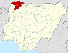 | |
This article is issued from Wikipedia. The text is licensed under Creative Commons - Attribution - Sharealike. Additional terms may apply for the media files.