Taupō Bay
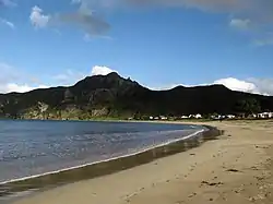
Taupō Bay is a bay, village and rural community in the Far North District and Northland Region of New Zealand's North Island.[1] There are about 40 permanent residents, and 180 properties. The white sand beach is 1.5 km wide.[2]
Taupō Bay | |
|---|---|
 Taupo Bay | |
| Coordinates: 34.992124°S 173.708853°E | |
| Country | New Zealand |
| Region | Northland Region |
| District | Far North District |
| Ward | Bay of Islands/Whangaroa |
| Electorates | |
| Government | |
| • Territorial Authority | Far North District Council |
| • Regional council | Northland Regional Council |
The Taupō Marae is a meeting place for the Ngāpuhi / Ngāti Kahu ki Whaingaroa hapū of Ngatirua.[3] It features Te Tiriti meeting house.[4]
Demographics
Whakapaku statistical area covers the western side of the Whangaroa Harbour and extends south to Otangaroa. It has an area of 200.87 km2 (77.56 sq mi)[5] and had an estimated population of 800 as of June 2023,[6] with a population density of 4.0 people per km2.
| Year | Pop. | ±% p.a. |
|---|---|---|
| 2006 | 705 | — |
| 2013 | 708 | +0.06% |
| 2018 | 744 | +1.00% |
| Source: [7] | ||
Whakapaku had a population of 744 at the 2018 New Zealand census, an increase of 36 people (5.1%) since the 2013 census, and an increase of 39 people (5.5%) since the 2006 census. There were 267 households, comprising 375 males and 375 females, giving a sex ratio of 1.0 males per female. The median age was 48.6 years (compared with 37.4 years nationally), with 156 people (21.0%) aged under 15 years, 81 (10.9%) aged 15 to 29, 342 (46.0%) aged 30 to 64, and 165 (22.2%) aged 65 or older.
Ethnicities were 76.2% European/Pākehā, 46.8% Māori, 2.4% Pacific peoples, and 1.6% Asian. People may identify with more than one ethnicity.
The percentage of people born overseas was 10.5, compared with 27.1% nationally.
Of those people who chose to answer the census's question about religious affiliation, 48.4% had no religion, 35.5% were Christian, 5.2% had Māori religious beliefs and 1.6% had other religions.
Of those at least 15 years old, 66 (11.2%) people had a bachelor's or higher degree, and 150 (25.5%) people had no formal qualifications. The median income was $22,300, compared with $31,800 nationally. 51 people (8.7%) earned over $70,000 compared to 17.2% nationally. The employment status of those at least 15 was that 216 (36.7%) people were employed full-time, 114 (19.4%) were part-time, and 27 (4.6%) were unemployed.[7]
References
- Hariss, Gavin. "Taupo Bay, Northland". topomap.co.nz. NZ Topo Map.
- "Best beach: Taupo Bay". New Zealand Herald. 18 January 2018.
- "Te Kāhui Māngai directory". tkm.govt.nz. Te Puni Kōkiri.
- "Māori Maps". maorimaps.com. Te Potiki National Trust.
- "ArcGIS Web Application". statsnz.maps.arcgis.com. Retrieved 2 April 2022.
- "Population estimate tables - NZ.Stat". Statistics New Zealand. Retrieved 25 October 2023.
- "Statistical area 1 dataset for 2018 Census". Statistics New Zealand. March 2020. Whakapaku (101500). 2018 Census place summary: Whakapaku