Taura, Jigawa
Taura is a Local Government Area of Jigawa State, Nigeria. Its headquarters is in the town of Taura. Most people in Taura are Hausa people, Taura Local government borders Garki to the North, Gagarawa to the east, Jahun to the south, and Ringim to the west.
Taura | |
|---|---|
LGA and town | |
 Taura | |
| Coordinates: 12°15′20″N 9°23′3″E | |
| Country | |
| State | Jigawa State |
| Government | |
| • Local Government Chairman | Baffa Yahaya (APC) |
| Area | |
| • Total | 252 sq mi (653 km2) |
| Population (2006) | |
| • Total | 131,757 |
| Time zone | UTC+1 (WAT) |
It has an area of 653 km2 (252 sq mi) and a population of 131,757 at the 2006 census.
The postal code of the area is 733.[1]
Taura has a fertile land for both wet and dry seasons farming activities. The Local Government produces both subsistence and cash crops and also has great number fruits trees scattered along the bank of the river. In addition to the farming activities majority of the populace, engaged in marketing. These economic resources enable most of the parents to possess means of paying their children’s school fees. The town was famous for its rich in groundnuts, tobacco production and trade, this motivated the British to construct railway from Kano to Nguru via the Taura town.
Climate
The climate is oppressive, mostly cloudy, with a year-round temperature range of 58°F to 103°F, with occasional dips below or above 108°F.[2][3]
Temperature
Taura's average temperature varies with the season; May is the hottest month and January is the coolest.[2]
References
- "Post Offices- with map of LGA". NIPOST. Archived from the original on 2012-11-26. Retrieved 2009-10-20.
- "Taura Climate, Weather By Month, Average Temperature (Nigeria) - Weather Spark". weatherspark.com. Retrieved 2023-09-08.
- "Taura, Jigawa, Nigeria - City, Town and Village of the world". en.db-city.com. Retrieved 2023-09-08.
State capital: Dutse | ||
| Local Government Areas | 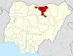 | |