Plainfield, Indiana
Plainfield is a town in Guilford, Liberty, and Washington townships, Hendricks County, Indiana, United States. The population was 27,631 at the 2010 census,[4] and in 2022 the estimated population was 36,074.[5]
Plainfield, Indiana | |
|---|---|
Town | |
 Plainfield Town Center | |
 Flag | |
| Motto: "A Community of Values" | |
 Location of Plainfield in Hendricks County, Indiana. | |
| Coordinates: 39°41′51″N 86°23′5″W | |
| Country | United States |
| State | Indiana |
| County | Hendricks |
| Township | Guilford, Liberty, Washington |
| Incorporated | 1839 |
| Government | |
| • Type | Town council |
| • Town manager | Andrew Klinger |
| Area | |
| • Total | 26.12 sq mi (67.66 km2) |
| • Land | 26.00 sq mi (67.33 km2) |
| • Water | 0.13 sq mi (0.33 km2) |
| Elevation | 715 ft (218 m) |
| Population (2020) | |
| • Total | 34,625 |
| • Density | 1,331.99/sq mi (514.28/km2) |
| Time zone | UTC−5 (EST) |
| • Summer (DST) | UTC−4 (EDT) |
| ZIP code | 46168 |
| Area code(s) | 317/463 |
| FIPS code | 18-60246[2] |
| GNIS feature ID | 0441219[3] |
| Website | www |
History

In 1822, a tract of land which included the area now known as Plainfield was obtained by Jeremiah Hadley of Preble County, Ohio. Ten years later he sold it to his son, Elias Hadley. Levi Jessup and Elias Hadley laid out the town in 1839. Plainfield was incorporated as a town in 1839.[6] The town got its name from the early Friends (Quakers) who settled around the area and established several meetinghouses throughout the county, including the important Western Yearly Meeting of Friends in Plainfield. The Friends were "plain" people, and thus the name "Plainfield". The high school continues to honor the Quakers, using the name for the school's mascot.
Plainfield has long been associated with the National Road, U.S. Route 40, which goes through town as Main Street. One incident which brought Plainfield national attention occurred in 1842 when former President Martin Van Buren was spilled deliberately from his stagecoach into the thick mud of the highway. The practical joke came as a result of Van Buren's vetoing a bill from Congress to improve the highway, a move which angered Western settlers. When Van Buren came through Plainfield on a swing to shore up his popularity for the 1844 election, a group of perpetrators set up the incident. The elm tree whose roots caused the president's carriage to topple became known as the Van Buren Elm. An elementary school near this site is named Van Buren Elementary School.[7][8][9]
In the 1980s Plainfield became the headquarters of the Islamic Society of North America.
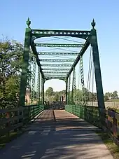
The Hendricks County Bridge Number 316, Plainfield Historic District, and THI and E Interurban Depot-Substation are listed on the National Register of Historic Places.[10]
Geography
According to the 2010 census, Plainfield has a total area of 22.38 square miles (57.96 km2), of which 22.27 square miles (57.68 km2) (or 99.51%) is land and 0.11 square miles (0.28 km2) (or 0.49%) is water.[11]
Plainfield is located in the Central Till Plains region of the United States. There are few moderately sized hills, and a mix of deciduous forests and prairie covers much of the area within the town limits. White Lick Creek, a tributary of the White River, flows north to south through the western side of Plainfield. On the eastern side of town, Clark's Creek, a tributary of White Lick Creek, flows towards the south.
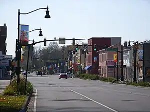
U.S. Route 40, also known as the Historic National Road and the Cumberland Road, passes through the middle of Plainfield and is the main arterial route running east to west in the town. From north to south runs Quaker Boulevard (former SR 267).
Plainfield's town center is situated around the intersection of U.S. Route 40 and Center Street, also known as Old State Highway 267.
Indianapolis International Airport borders the east side of Plainfield, in Marion County.
Demographics
| Census | Pop. | Note | %± |
|---|---|---|---|
| 1850 | 251 | — | |
| 1870 | 795 | — | |
| 1880 | 50 | −93.7% | |
| 1890 | 909 | 1,718.0% | |
| 1910 | 1,303 | — | |
| 1920 | 1,373 | 5.4% | |
| 1930 | 1,617 | 17.8% | |
| 1940 | 1,811 | 12.0% | |
| 1950 | 2,585 | 42.7% | |
| 1960 | 5,460 | 111.2% | |
| 1970 | 8,211 | 50.4% | |
| 1980 | 9,191 | 11.9% | |
| 1990 | 10,433 | 13.5% | |
| 2000 | 18,396 | 76.3% | |
| 2010 | 27,631 | 50.2% | |
| 2020 | 34,625 | 25.3% | |
| Source: US Census Bureau | |||
2010 census
As of the census[12] of 2010, there were 27,631 people, 9,747 households, and 6,756 families residing in the town. The population density was 1,240.7 inhabitants per square mile (479.0/km2). There were 10,386 housing units at an average density of 466.4 per square mile (180.1/km2). The racial makeup of the town was 85.7% White, 7.8% African American, 0.1% Native American, 3.2% Asian, 1.4% from other races, and 1.7% from two or more races. Hispanic or Latino of any race were 3.9% of the population.
There were 9,747 households, of which 37.1% had children under the age of 18 living with them, 52.0% were married couples living together, 12.3% had a female householder with no husband present, 5.0% had a male householder with no wife present, and 30.7% were non-families. 25.7% of all households were made up of individuals, and 8.7% had someone living alone who was 65 years of age or older. The average household size was 2.57 and the average family size was 3.08.
The median age in the town was 35.5 years. 24.5% of residents were under the age of 18; 9% were between the ages of 18 and 24; 30.9% were from 25 to 44; 24.3% were from 45 to 64; and 11.3% were 65 years of age or older. The gender makeup of the town was 52.8% male and 47.2% female.
Economy
The economic engine of Plainfield is the sprawling warehouse district on the east side of town, close to the Indianapolis International Airport, that boasts approximately 45 million square feet of space. Plainfield provides roughly 50% of all warehouse jobs in central Indiana.[13]
"The Shops at Perry Crossing" is a 600,000-square-foot (56,000 m2) open-air retail mall. It opened in October 2005 and was purchased in February 2014 by Poag Shopping Centers,[14] which currently operates the mall.[15][16] The mall received a $11.1 million renovation and rebranding project to revitalize the shopping center; the project concluded in November 2015.[17]
Plainfield boasts 18 hotels, including an Embassy Suites full-service hotel and conference center. The town's proximity to the Indianapolis airport and Interstate 70 have made it an attractive location for hotel space.
The town is currently renovating the downtown area with a new apartment complex, The Barlow, as well as an upcoming Performing and Fine Arts Center, connected to the government building.
Arts and culture
The town has a lending library, the Plainfield-Guilford Township Public Library.[18] The library contains an upstairs art gallery showcasing local artists and photographers.
The Richard A. Carlucci Recreation and Aquatic Center is 11,300 square feet (1,050 m2) and includes basketball courts, an indoor walk/run track, a waterpark, a fitness center, and an indoor play area.[19][20] There is also an indoor waterpark with three lap lanes, a walking river with current, a kids' play area, and a large waterslide.[21]
Plainfield's trail system includes over 20 miles (32 km) of pathways, and incluses the Vandalia Trail which runs almost 5 miles (8 km) through the center of Plainfield.
Hummel Park is a 205 acres (83 ha) park with a 300-foot (91 m) wooden bridge across White Lick Creek. The park features sports venues, basketball and volleyball courts, baseball diamonds, nature trails, fishing lakes and an amphitheater.[22]
Government
The Plainfield Correctional Facility (formerly Indiana Youth Center) of the Indiana Department of Correction is in the western part of Plainfield.[23] As of 2019, the prison housed 1,497 inmates, and employed 341 staff.[24]
Education
Public school system
Plainfield's public education system is run by the Plainfield Community School Corporation. The schools under this body include:
- Guilford Elementary School
- Brentwood Elementary School
- Central Elementary School
- Van Buren Elementary School
- Clarks Creek Elementary School
- Plainfield Community Middle School
- Plainfield High School
The Plainfield Community School Corporation is the only public school system in Indiana to have all of its schools receive a 4-star rating for two consecutive years. In 2019, a petition requesting a Master Plan and Architectural and Site Design Review for a new elementary school complex located south and west of the intersection of Hadley and Moon Roads (Guildford Elementary). Hendricks County has ceded planning jurisdiction to the Town of Plainfield for this project. In 2009, a new High School was constructed. The former High School became the Middle School, and the former middle school building was converted into "Clarks Creek Elementary", an upper elementary school for grades 4-5. However, as of the 2019-2020 school year, the corporation changed this setup to a High School (9-12), Middle School(6-8), and Five K-5 elementary schools.[25]
Private school systems
Private schools in Plainfield include St. Susanna Catholic School, which is run by St. Susanna Catholic Church of Plainfield.
Transportation
The Central Indiana Regional Transportation Authority operates a commuter bus serving major employers in the town.[26]
Notable people
- Mark Hampton, notable interior designer, was from Plainfield.
- Del Harris, basketball coach, was raised in Plainfield.
- Lawson Harvey, Justice of the Indiana Supreme Court
- Ron McQueeney, director of photography at Indianapolis Motor Speedway, was raised in Plainfield.
- Chris Stout, founding director of the Center for Global Initiatives, graduated from Plainfield High School.
- Forrest Tucker, actor, was born in Plainfield.
- James Hurst (American football), offensive lineman for the New Orleans Saints.
- Ms. Pat,[27] comedian, moved to Plainfield in 2006
See also
References
![]() Media related to Plainfield, Indiana at Wikimedia Commons
Media related to Plainfield, Indiana at Wikimedia Commons
- "2020 U.S. Gazetteer Files". United States Census Bureau. Retrieved March 16, 2022.
- "U.S. Census website". United States Census Bureau. Retrieved January 31, 2008.
- "US Board on Geographic Names". United States Geological Survey. October 25, 2007. Retrieved January 31, 2008.
- "Geographic Identifiers: 2010 Demographic Profile Data (G001): Plainfield town, Indiana". American Factfinder. U.S. Census Bureau. Retrieved June 20, 2017.
- "Population and Housing Unit Estimates". Retrieved June 4, 2023.
- Hadley, John Vestal (1914). History of Hendricks County, Indiana: Her People, Industries and Institutions. B.F. Bowen. pp. 77.
- Margaret Moore Post: "Our Town Yesterday."
- John R. McDowell, The History of Hendricks County.
- "Town History - Town of Plainfield". Archived from the original on June 9, 2011.
- "National Register Information System". National Register of Historic Places. National Park Service. July 9, 2010.
- "G001 - Geographic Identifiers - 2010 Census Summary File 1". United States Census Bureau. Archived from the original on February 13, 2020. Retrieved July 17, 2015.
- "U.S. Census website". United States Census Bureau. Retrieved December 11, 2012.
- "13 WTHR Indianapolis". 13 WTHR Indianapolis. Retrieved April 7, 2019.
- Memphis company Poag buys Metropolis mall in Plainfield. indystar.com (2014-02-10). Retrieved on October 11, 2014.
- "Metropolis mall plans new name, $11M renovation". Indianapolis Star. Retrieved October 19, 2015.
- "Metropolis announces $11.1 million renovation and name change to The Shops at Perry Crossing :: 05/06/2015 :: The Shops at Perry Crossing, Plainfield, IN". The Shops at Perry Crossing. Archived from the original on November 16, 2015. Retrieved October 19, 2015.
- "Plainfield Shopping Center to Change Name". www.insideindianabusiness.com. Retrieved October 19, 2015.
- "Indiana public library directory" (PDF). Indiana State Library. Archived from the original (PDF) on February 18, 2017. Retrieved March 7, 2018.
- "Richard A. Carlucci Recreation & Aquatic Center | Plainfield, IN".
- "Plainfield Splash Island, IN | Official Website". www.splashislandplainfield.com.
- "Indoor Aquatic Center | Plainfield Splash Island, IN".
- "Hummel Park - Indiana's Largest Township Park", Retrieved on January 2, 2013.
- "2009 Annual Report". Indiana Department of Correction. 49 (49/100). Retrieved on August 27, 2010.
- "Archived copy" (PDF). Archived from the original (PDF) on August 6, 2020. Retrieved January 5, 2020.
{{cite web}}: CS1 maint: archived copy as title (link) - "Plainfield Community School Corporation". www.plainfield.k12.in.us. Retrieved April 23, 2023.
- "Plainfield Connector". Retrieved September 5, 2023.
- "The Ms. Pat Show brings Plainfield and a different kind of mama to the sitcom screen". Retrieved August 1, 2022.
Places adjacent to Plainfield, Indiana | ||||||||||||||||
|---|---|---|---|---|---|---|---|---|---|---|---|---|---|---|---|---|
| ||||||||||||||||
Municipalities and communities of Hendricks County, Indiana, United States | ||
|---|---|---|
| Towns | Map of Indiana highlighting Hendricks County | |
| Townships | ||
| CDPs | ||
| Other communities | ||
| Footnotes | ‡This populated place also has portions in an adjacent county or counties | |
