Portal:Indiana
The Indiana Portal

Various indigenous peoples inhabited what would become Indiana for thousands of years, some of whom the U.S. government expelled between 1800 and 1836. Indiana received its name because the state was largely possessed by native tribes even after it was granted statehood. Since then, settlement patterns in Indiana have reflected regional cultural segmentation present in the Eastern United States; the state's northernmost tier was settled primarily by people from New England and New York, Central Indiana by migrants from the Mid-Atlantic states and adjacent Ohio, and Southern Indiana by settlers from the Upland South, particularly Kentucky and Tennessee.
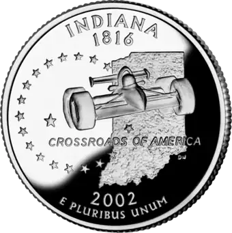
Indiana has a diverse economy with a gross state product of $352.62 billion in 2021. It has several metropolitan areas with populations greater than 100,000 and a number of smaller cities and towns. Indiana is home to professional sports teams, including the NFL's Indianapolis Colts and the NBA's Indiana Pacers. The state also hosts several notable competitive events, such as the Indianapolis 500, held at Indianapolis Motor Speedway. (Full article...)
Selected article -
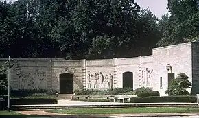
The Indiana World War Memorial Plaza is an urban feature and war memorial located in downtown Indianapolis, Indiana, United States, originally built to honor the veterans of World War I. It was conceived in 1919 as a location for the national headquarters of the American Legion and a memorial to the state's and nation's veterans.
The original five-block plaza is bounded by Meridian Street (west), St. Clair Street (north), Pennsylvania Street (east), and New York Street (south). American Legion Mall comprises the two northernmost blocks and is home to the Legion's administrative buildings and a cenotaph. Veterans Memorial Plaza, with its obelisk, forms the third block. The plaza's focal point, the Indiana World War Memorial, is located on the fourth block. Modeled after the Mausoleum of Halicarnassus, it houses a military museum and auditorium. The fifth and southernmost block is University Park, home to statues and a fountain. (Full article...)Selected image -
Did you know -
- ... that the existence of Lego Indiana Jones 2: The Adventure Continues was accidentally leaked when it was displayed on an animator's résumé?
- ... that a woman hitchhiked from Indiana to Washington, D.C., to protest the sale of the radio station where she worked?
- ... that Ganggang, an Indianapolis-based cultural development firm for Black artists, created a fine art fair called "Butter" that also included a dance party called "Melt"?
- ... that the 1938 film Road Demon contains footage of well-known accidents that occurred at Indianapolis Motor Speedway?
- ... that Hurley Goodall was appointed back onto the school board in Muncie, Indiana, following the death of his successor in a plane crash?
- ... that in 1981 Indiana State University–Evansville received a donation valued at nearly $300,000 in the form of campus radio station WSWI?
Related portals
Selected geographic article -

Terre Haute (/ˈtɛrə ˈhoʊt/ TERR-ə HOHT) is a city in and the county seat of Vigo County, Indiana, United States, about 5 miles east of the state's western border with Illinois. As of the 2020 census, the city had a population of 58,389 and its metropolitan area had a population of 168,716.
Located along the Wabash River, Terre Haute is one of the largest cities in the Wabash Valley and is known as the Queen City of the Wabash. The city is home to multiple higher-education institutions, including Indiana State University, Rose-Hulman Institute of Technology, and Ivy Tech Community College of Indiana. (Full article...)Selected biography -
Peter Paul Montgomery Buttigieg (/ˈbuːtədʒədʒ/ BOOT-ə-jəj; born January 19, 1982) is an American politician and former naval officer who is currently serving as the 19th United States Secretary of Transportation. A member of the Democratic Party, he was the 32nd mayor of South Bend, Indiana, from 2012 to 2020, which earned him the nickname "Mayor Pete".
Buttigieg is a graduate of Harvard College and the University of Oxford, attending the latter on a Rhodes Scholarship. From 2009 to 2017, he was an intelligence officer in the United States Navy Reserve, attaining the rank of lieutenant. He was mobilized and deployed to the War in Afghanistan for seven months in 2014. Before being elected as mayor of South Bend in 2011, Buttigieg worked on the political campaigns of Democrats Jill Long Thompson, Joe Donnelly, and John Kerry, and ran unsuccessfully as the Democratic nominee for Indiana state treasurer in 2010. While serving as South Bend's mayor, Buttigieg came out as gay in 2015. He married Chasten Glezman, a schoolteacher and writer, in June 2018. Buttigieg declined to seek a third term as mayor. (Full article...)Selected quote
General images

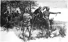 Native Americans guide French explorers through Indiana as depicted by Maurice Thompson in Stories of Indiana. (from History of Indiana)
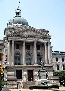 The fifth Indiana Statehouse in Indianapolis built in 1888 on the site of the third statehouse (from History of Indiana)
 The Constitution Elm in Corydon (from History of Indiana)
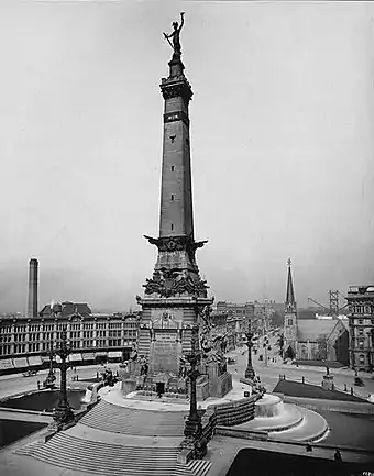 The Circle in Indianapolis, circa 1898 (from History of Indiana)
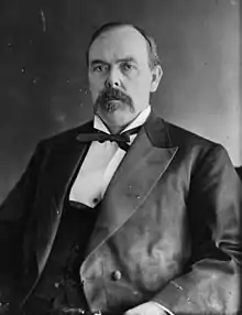 Oliver Hazard Perry Morton, governor 1861 to 1867 (from History of Indiana)
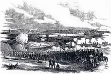 80th Indiana Infantry Regiment and the 19th Indiana Light Artillery defending against the Confederates at the Battle of Perryville by H. Mosler (from History of Indiana)
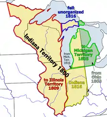 Map of the Indiana Territory (from History of Indiana)
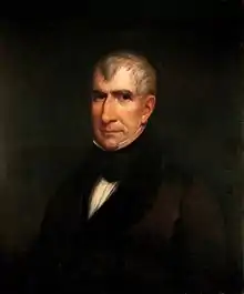 William Henry Harrison, the 1st Governor of Indiana Territory from 1801 to 1812, and the 9th President of the United States (from History of Indiana)
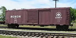 A restored Monon boxcar at the Linden Railroad Museum in Linden, Indiana (from History of Indiana)
 View of Mound A at Angel Mounds (from History of Indiana)
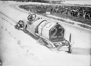 Driver Mel Marquette's wrecked McFarlan racing car at the 1912 Indianapolis 500 (from History of Indiana)
.jpg.webp)
 Madame C. J. Walker, Indianapolis entrepreneur and philanthropist (from History of Indiana)
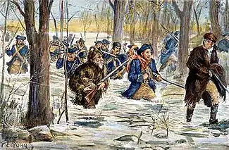 Clark's march to Vincennes, by F. C. Yohn (from History of Indiana)
Topics
- Economy: AM General - ATA Airlines - Casinos - Cummins - Delta - ITT - JayC - Lilly - Limestone - Manufacturing - NiSource - Shoe Carnival - Simon Property Group - Soybeans - Studebaker - Vectren - WellPoint
- Education: Elementary schools - Middle schools - High schools - Private schools - School districts - Colleges and universities - E-Learning - ISTEP
- Geography: Caves - Lakes - Rivers - State forests - Watersheds
| Executive |  | |
|---|---|---|
| Legislature | ||
| Judiciary |
| |
| Departments | ||
| Local government | ||
| Law | ||
Sports teams based in Indiana | |||||||||
|---|---|---|---|---|---|---|---|---|---|
| Baseball |  | ||||||||
| Basketball | |||||||||
| Football | |||||||||
| Hockey | |||||||||
| Roller derby | |||||||||
| Soccer | |||||||||
| Ultimate | |||||||||
| College athletics |
| ||||||||

Categories
Attractions


 What would become Indiana Dunes State Park in 1916 |

Recognized content
| This is a list of recognized content, updated weekly by JL-Bot (talk · contribs) (typically on Saturdays). There is no need to edit the list yourself. If an article is missing from the list, make sure it is tagged (e.g. {{WikiProject Indiana}}) or categorized correctly and wait for the next update. See WP:RECOG for configuration options. |
Good articles
- 1963 Indiana State Fairgrounds Coliseum gas explosion
- 2006 Brickyard 400
- 2011 South Bend mayoral election
- 2015 South Bend mayoral election
- 2019 South Bend mayoral election
- 2021 NCAA Division I men's basketball championship game
- The Fault in Our Stars (film)
- Hurley Goodall
- Proposed South Shore Line station in South Bend
- WCAE
Featured pictures
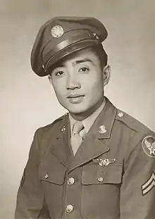 Kenje Ogata 1943
 US-NBN-IL-Lebanon-2057-Orig-1-400-C
WikiProjects
![]()
- US-related WikiProjects
- Indiana
- Indiana State Roads
- Indianapolis
- Indiana
State facts
Indiana | |
|---|---|
| Country | United States |
| Admitted to the Union | December 11, 1816 (19th) |
| Capital | Indianapolis |
| Largest city | Indianapolis |
| Largest metro and urban areas | Indianapolis-Carmel MSA |
| Government | |
| • Governor | Eric Holcomb (R) (2017) |
| • Lieutenant Governor | Suzanne Crouch (R) (2017) |
| Legislature | Indiana General Assembly |
| • Upper house | Senate |
| • Lower house | House of Representatives |
| U.S. senators | Todd Young (R) Mike Braun (R) |
| Population | |
| • Total | 6,080,485 |
| • Density | 169.5/sq mi (65.46/km2) |
| Language | |
| • Official language | English |
| Latitude | 37° 46′ N to 41° 46′ N |
| Longitude | 84° 47′ W to 88° 6′ W |
.JPG.webp)


Things you can do
 |
Here are some tasks awaiting attention:
|
Associated Wikimedia
The following Wikimedia Foundation sister projects provide more on this subject:
-
 Commons
Free media repository -
 Wikibooks
Free textbooks and manuals -
 Wikidata
Free knowledge base -
 Wikinews
Free-content news -
 Wikiquote
Collection of quotations -
 Wikisource
Free-content library -
 Wikiversity
Free learning tools -
 Wikivoyage
Free travel guide -
 Wiktionary
Dictionary and thesaurus
-
 List of all portalsList of all portals
 -
 The arts portal
 -
 Biography portal
 -
 Current events portal
 -
 Geography portal
 -
 History portal
 -
 Mathematics portal
 -
 Science portal
 -
 Society portal
 -
 Technology portal
 -
 Random portalRandom portal
 -
 WikiProject PortalsWikiProject Portals