Tichá Orlice
The Tichá Orlice is a river in the Czech Republic, the secondary source river of the Orlice River. It flows through the Hradec Králové and Pardubice regions. It is 101.8 km (63.3 mi) long, which makes it the 21st longest river in the Czech Republic.
| Tichá Orlice | |
|---|---|
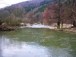 The Tichá Orlice in Orlické Podhůří | |
| Location | |
| Country | Czech Republic |
| Regions | |
| Physical characteristics | |
| Source | |
| • location | Červená Voda, Hanušovice Highlands |
| • elevation | 809 m (2,654 ft) |
| Mouth | |
• location | Orlice |
• coordinates | 50°21′30″N 16°26′5″E |
• elevation | 249 m (817 ft) |
| Length | 101.8 km (63.3 mi) |
| Basin size | 756.4 km2 (292.0 sq mi) |
| Discharge | |
| • average | 7.4 m3/s (260 cu ft/s) near estuary |
| Basin features | |
| Progression | Orlice→ Elbe→ North Sea |
Etymology
The name Orlice is derived from the Slavic word orel, i.e. 'eagle' (literally "female eagle"). The river probably got its name from the abundance of eagles, but it could also have just been the accidental catch of an eagle. The attribute tichá means 'silent' and refers to its character (compared to Divoká Orlice, i.e. "wild Orlice").[1][2]
Characteristic
.jpg.webp)
The Tichá Orlice originates in the territory of Červená Voda in the Hanušovice Highlands at the elevation of 809 m (2,654 ft) and flows to Žďár nad Orlicí, where it merges with the Divoká Orlice at the elevation of 249 m (817 ft) and together they form the Orlice. It is 101.8 km (63.3 mi) long, which makes it the 21st longest river in the Czech Republic. Its drainage basin has an area of 756.4 km2 (292.0 sq mi).[3]
The longest tributaries of the Tichá Orlice are:
| Tributary | Length (km) | River km | Side |
|---|---|---|---|
| Třebovka | 41.2 | 48.2 | left |
| Čermná | 13.8 | 71.3 | left |
| Lipkovský potok | 13.4 | 93.6 | right |
Flow
The largest town on the river is Ústí nad Orlicí. The river flows through the municipal territories of Červená Voda, Králíky, Lichkov, Mladkov, Těchonín, Sobkovice, Jamné nad Orlicí, Jablonné nad Orlicí, Mistrovice, Verměřovice, Letohrad, Dolní Dobrouč, Ústí nad Orlicí, Hrádek, Orlické Podhůří, Sudislav nad Orlicí, Brandýs nad Orlicí, Zářecká Lhota, Choceň, Újezd u Chocně, Čermná nad Orlicí, Borohrádek and Žďár nad Orlicí.
Bodies of water
There are 557 bodies of water in the basin area. The largest of them is the Hvězda fishpond with an area of 75 ha (190 acres).[3]
Fauna
The entire course of the river is protected as a Special Area of Conservation for the abundant occurrence of the European river lamprey.[4]
Tourism
The Tichá Orlice is suitable for river tourism, but the upper course is suitable only for experienced paddlers. The lower course is popular because of its year-round navigability.[4]
References
- Loucká, Pavla (1997-09-05). "Řeky si pojmenovali nejdřív" (in Czech). Vesmír. Retrieved 2023-10-05.
- "Řeka Orlice – dvě řeky v jednu spojené" (in Czech). CzechTourism. Retrieved 2023-10-05.
- "Základní charakteristiky toku Tichá Orlice a jeho povodí" (in Czech). T. G. Masaryk Water Research Institute. Retrieved 2023-10-05.
- "Tichá Orlice – nejkrásnější řeka východních Čech" (in Czech). CzechTourism. Retrieved 2023-10-06.
External links
- River flow at Čermná nad Orlicí station – Flood Warning and Forecasting Service of the Czech Hydrometeorological Institute