Tikorangi
Tikorangi is a settlement in Taranaki, New Zealand. Waitara lies about 6 kilometres to the north-west. The Waitara River flows to the west of the settlement, with the Bertrand Road suspension bridge providing access to the other side.[1][2] The Mangaemiemi or Otaraua Marae and Te Ahi Kaa Roa meeting house are a local meeting place for Otaraua, a hapū of Te Āti Awa.[3][4]
Tikorangi | |
|---|---|
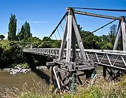 The Bertrand road suspension bridge | |
| Coordinates: 39°2′2″S 174°16′47″E | |
| Country | New Zealand |
| Region | Taranaki Region |
| Territorial authority | New Plymouth District |
| Ward |
|
| Community | Clifton Community |
| Electorates | |
| Government | |
| • Territorial Authority | New Plymouth District Council |
| • Regional council | Taranaki Regional Council |
Tikorangi was the site of the Tikorangi Redoubt, a British military post set up in June 1865 during the Second Taranaki War.[5]
Tikorangi's Jury Garden has been awarded the highest rating by the New Zealand Gardens Trust: Garden of National Significance. It is open to the public for part of the year.[6]
The Bertrand Road suspension bridge connects Tikorangi to Huirangi.[7]
Demographics
Tikorangi statistical area includes Motunui, Onaero and Urenui and covers 167.71 km2 (64.75 sq mi)[8] and had an estimated population of 2,140 as of June 2022,[9] with a population density of 13 people per km2.
| Year | Pop. | ±% p.a. |
|---|---|---|
| 2006 | 1,590 | — |
| 2013 | 1,776 | +1.59% |
| 2018 | 1,902 | +1.38% |
| Source: [10] | ||
The statistical area had a population of 1,902 at the 2018 New Zealand census, an increase of 126 people (7.1%) since the 2013 census, and an increase of 312 people (19.6%) since the 2006 census. There were 744 households, comprising 990 males and 912 females, giving a sex ratio of 1.09 males per female. The median age was 45.8 years (compared with 37.4 years nationally), with 345 people (18.1%) aged under 15 years, 264 (13.9%) aged 15 to 29, 936 (49.2%) aged 30 to 64, and 360 (18.9%) aged 65 or older.
Ethnicities were 90.2% European/Pākehā, 18.3% Māori, 0.9% Pacific peoples, 0.9% Asian, and 2.2% other ethnicities. People may identify with more than one ethnicity.
The percentage of people born overseas was 9.3, compared with 27.1% nationally.
Although some people chose not to answer the census's question about religious affiliation, 56.5% had no religion, 32.6% were Christian, 0.6% had Māori religious beliefs, 0.2% were Hindu, 0.3% were Muslim, 0.3% were Buddhist and 1.4% had other religions.
Of those at least 15 years old, 204 (13.1%) people had a bachelor's or higher degree, and 339 (21.8%) people had no formal qualifications. The median income was $33,600, compared with $31,800 nationally. 264 people (17.0%) earned over $70,000 compared to 17.2% nationally. The employment status of those at least 15 was that 825 (53.0%) people were employed full-time, 234 (15.0%) were part-time, and 42 (2.7%) were unemployed.[10]
Education
Tikorangi School is a coeducational contributing primary (years 1–6) school with a roll of 156 students as of April 2023.[11][12] The school opened in 1867.[13]
Notes
- Peter Dowling, ed. (2004). Reed New Zealand Atlas. Reed Books. pp. map 34. ISBN 0-7900-0952-8.
- Roger Smith, GeographX (2005). The Geographic Atlas of New Zealand. Robbie Burton. pp. map 85. ISBN 1-877333-20-4.
- "Te Kāhui Māngai directory". tkm.govt.nz. Te Puni Kōkiri.
- "Māori Maps". maorimaps.com. Te Potiki National Trust.
- Prickett, Nigel (1999). "BRITISH ARMY AND COLONIAL FORTIFICATIONS IN NORTH TARANAKI, 1865-69". Records of the Auckland Institute and Museum. 36: 5–58. ISSN 1174-9202.
- "Tikorangi The Jury Garden". Retrieved 8 July 2008.
- "'IPENZ Heritage Newsletter June 2007'" (PDF). Archived from the original (PDF) on 14 October 2007. Retrieved 31 May 2013. page 5
- "ArcGIS Web Application". statsnz.maps.arcgis.com. Retrieved 13 March 2023.
- "Population estimate tables - NZ.Stat". Statistics New Zealand. Retrieved 25 October 2022.
- "Statistical area 1 dataset for 2018 Census". Statistics New Zealand. March 2020. Tikorangi (219400). 2018 Census place summary: Tikorangi
- "New Zealand Schools Directory". New Zealand Ministry of Education. Retrieved 12 December 2022.
- Education Counts: Tikorangi School
- Watson, Mike (1 February 2018). "The capsule that time forgot: Where was school's anniversary memorial buried?". Stuff.