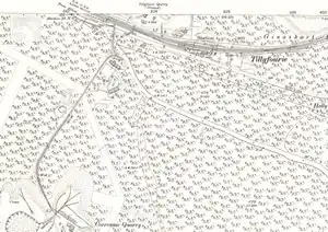
Tillyfourie railway station
Tillyfourie railway station was a railway station serving Tillyfourie, Aberdeenshire, Scotland.
Tillyfourie | |
|---|---|
 The station shown on a 1900 OS map | |
| General information | |
| Location | Aberdeenshire Scotland |
| Coordinates | 57.2004°N 2.5879°W |
| Platforms | 2 |
| Other information | |
| Status | Disused |
| History | |
| Original company | Alford Valley Railway |
| Pre-grouping | Great North of Scotland Railway |
| Post-grouping | LNER |
| Key dates | |
| 2 June 1860 | Opened |
| 2 January 1950 | Closed |
| 3 January 1966 | Line closed |
Alford Valley Railway | ||||||||||||||||||||||||||||||||||||||||||||||||||||||||||||||||||||||||||||||||||||||||||||||||||
|---|---|---|---|---|---|---|---|---|---|---|---|---|---|---|---|---|---|---|---|---|---|---|---|---|---|---|---|---|---|---|---|---|---|---|---|---|---|---|---|---|---|---|---|---|---|---|---|---|---|---|---|---|---|---|---|---|---|---|---|---|---|---|---|---|---|---|---|---|---|---|---|---|---|---|---|---|---|---|---|---|---|---|---|---|---|---|---|---|---|---|---|---|---|---|---|---|---|---|
| ||||||||||||||||||||||||||||||||||||||||||||||||||||||||||||||||||||||||||||||||||||||||||||||||||
The station opened on 2 June 1860 on the Alford Valley Railway a year after the 16.5 miles (26.6 km) line between Kintore and Alford.[1][2]
Originally the station had one platform on the south side of the single track railway, and one siding to the west of the station.[3] By 1900 the line through the station had become a passing loop and there were two platforms connected with a footbridge, a signal box was located to the east. There were three sidings that were able to accommodate most types of goods including live stock.[4][5]
The station closed on 2 January 1950, the sidings were removed by 1960 when even the daily freight train did not call.[6][7] The line closed completely on 3 January 1966 when all services were withdrawn between Paradise Siding and Alford.[8]
| Preceding station | Historical railways | Following station | ||
|---|---|---|---|---|
| Whitehouse Line and station closed |
Great North of Scotland Railway Alford Valley Railway |
Monymusk Line and station closed | ||
References
Citations
- Vallance 1965, p. 61.
- Grant 2017, p. 10.
- "Ordnance Survey 25 inch map Aberdeenshire LXIII.15 (Monymusk)". National Library of Scotland. 1866. Retrieved 5 June 2021.
- "Ordnance Survey 25 inch map Aberdeenshire LXIII.15 (Cluny; Monymusk; Tough)". National Library of Scotland. 1900. Retrieved 5 June 2021.
- The Railway Clearing House 1970, p. 534.
- Quick 2022, p. 447.
- J. Spencer Gilks (January 1960). "With the Freight to Alford". The Railway Magazine. 106 (705): 29.
- Hurst 1992, p. 41 (ref 1888).
Bibliography
- Grant, Donald J. (2017). Directory of the Railway Companies of Great Britain (1st ed.). Kibworth Beauchamp, Leicestershire: Troubador Publishing Ltd. ISBN 978-1-78803-768-6.
- Hurst, Geoffrey (1992). Register of Closed Railways: 1948-1991. Worksop, Nottinghamshire: Milepost Publications. ISBN 0-9477-9618-5.
- Quick, Michael (2022) [2001]. Railway passenger stations in Great Britain: a chronology (PDF). version 5.04. Railway & Canal Historical Society. Archived from the original (PDF) on 25 November 2022.
- The Railway Clearing House (1970) [1904]. The Railway Clearing House Handbook of Railway Stations 1904 (1970 D&C Reprint ed.). Newton Abbot: David & Charles Reprints. ISBN 0-7153-5120-6.
- Vallance, Hugh Aymer (1965). The Great North of Scotland Railway. Dawlish: David & Charles. OCLC 854597610.