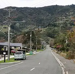
Todds Valley
Todds Valley is a small township to the north of Nelson, New Zealand. It lies to the southeast of State Highway 6, immediately to the north of Marybank, New Zealand at the northern tip of Nelson Haven.
Todds Valley | |
|---|---|
Town | |
 Street of Todds Valley | |
| Coordinates: 41°13′0″S 173°20′20″E | |
| Country | New Zealand |
| Region | Nelson |
| Ward |
|
| Electorates | |
| Government | |
| • Territorial Authority | Nelson City Council |
| • Mayor of Nelson | Nick Smith |
| • Nelson MP | Blair Cameron |
| • Te Tai Tonga MP | Tākuta Ferris |
| Area | |
| • Total | 4.40 km2 (1.70 sq mi) |
| Population (2018 Census)[2] | |
| • Total | 108 |
| • Density | 25/km2 (64/sq mi) |
Demographics
Todds Valley is in an SA1 statistical area which covers 4.40 km2 (1.70 sq mi).[1] It is part of the Nelson Rural statistical area.[3]
| Year | Pop. | ±% p.a. |
|---|---|---|
| 2006 | 81 | — |
| 2013 | 126 | +6.52% |
| 2018 | 108 | −3.04% |
| Source: [2] | ||
Todds Valley had a population of 108 at the 2018 New Zealand census, a decrease of 18 people (−14.3%) since the 2013 census, and an increase of 27 people (33.3%) since the 2006 census. There were 42 households, comprising 60 males and 51 females, giving a sex ratio of 1.18 males per female. The median age was 46.8 years (compared with 37.4 years nationally), with 18 people (16.7%) aged under 15 years, 9 (8.3%) aged 15 to 29, 69 (63.9%) aged 30 to 64, and 15 (13.9%) aged 65 or older.
Ethnicities were 100.0% European/Pākehā, and 8.3% Māori. People may identify with more than one ethnicity.
Although some people chose not to answer the census's question about religious affiliation, 75.0% had no religion, 13.9% were Christian and 5.6% had other religions.
Of those at least 15 years old, 33 (36.7%) people had a bachelor's or higher degree, and 9 (10.0%) people had no formal qualifications. The median income was $37,600, compared with $31,800 nationally. 18 people (20.0%) earned over $70,000 compared to 17.2% nationally. The employment status of those at least 15 was that 45 (50.0%) people were employed full-time, and 21 (23.3%) were part-time.[2]
References
- "ArcGIS Web Application". statsnz.maps.arcgis.com. Retrieved 15 July 2023.
- "Statistical area 1 dataset for 2018 Census". Statistics New Zealand. March 2020. 7022878.
- 2018 Census place summary: Nelson Rural