Tomberlin, Arkansas
Tomberlin (formerly Haberton) is an unincorporated community in Indian Bayou Township, Lonoke County, Arkansas, United States.[2] It is located along Highway 31 at an intersection with Tar Bottom Road.[3] Just north of Tomberlin is the Walls Farm Barn and Corn Crib, listed on the National Register of Historic Places.
Tomberlin, Arkansas | |
|---|---|
 Tomberlin  Tomberlin | |
| Coordinates: 34°30′57″N 91°52′18″W | |
| Country | |
| State | |
| County | Washington |
| Township | Indian Bayou |
| Elevation | 220 ft (67 m) |
| Time zone | UTC-6 (Central (CST)) |
| • Summer (DST) | UTC-5 (CDT) |
| ZIP code | 72046 |
| Area code | 870 |
| GNIS feature ID | 58753 |
| U.S. Geological Survey Geographic Names Information System: Tomberlin, Arkansas | |
References
- "Tomberlin, Arkansas". Histopolis. Retrieved October 19, 2011.
- U.S. Geological Survey Geographic Names Information System: Tomberlin, Arkansas United States Geological Survey. Retrieved October 19, 2011.
- Arkansas Atlas and Gazetteer (Map) (Second ed.). DeLorme. § 50.
Municipalities and communities of Lonoke County, Arkansas, United States | ||
|---|---|---|
| Cities | 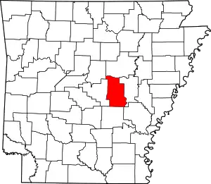 Map of Arkansas highlighting Lonoke County | |
| Towns | ||
| CDP | ||
| Unincorporated communities | ||
| Footnotes | ‡This populated place also has portions in an adjacent county or counties | |
This article is issued from Wikipedia. The text is licensed under Creative Commons - Attribution - Sharealike. Additional terms may apply for the media files.