Tonganoxie, Kansas
Tonganoxie (pronounced /tɒŋɡəˈnɒksi/)[5] is a city in Leavenworth County, Kansas, United States[1] and is part of the Kansas City metropolitan area.[6] As of the 2020 census, the population of the city was 5,573.[3][4]
Tonganoxie, Kansas | |
|---|---|
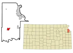 Location within Leavenworth County and Kansas | |
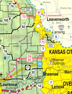 KDOT map of Leavenworth County (legend) | |
| Coordinates: 39°06′32″N 95°04′51″W[1] | |
| Country | United States |
| State | Kansas |
| County | Leavenworth |
| Platted | 1866 |
| Incorporated | 1871 |
| Government | |
| • Type | Council–manager |
| • Mayor | David Frese |
| • City Manager | George Brajkovic |
| Area | |
| • Total | 4.09 sq mi (10.60 km2) |
| • Land | 4.05 sq mi (10.50 km2) |
| • Water | 0.04 sq mi (0.10 km2) |
| Elevation | 850 ft (260 m) |
| Population | |
| • Total | 5,573 |
| • Density | 1,400/sq mi (530/km2) |
| Time zone | UTC-6 (CST) |
| • Summer (DST) | UTC-5 (CDT) |
| ZIP code | 66086 |
| Area code | 913 |
| GNIS ID | 2397035[1] |
| Website | tonganoxie.org |
History
Tonganoxie was platted in 1866.[7][8] It was named for a local Native American Chief from the Delaware Tribe whose name means "shorty" in the Delaware language.[9] Tonganoxie was incorporated as a city in 1871.[10]
Geography
According to the United States Census Bureau, the city has a total area of 3.67 square miles (9.51 km2), of which 3.66 square miles (9.48 km2) is land and 0.01 square miles (0.03 km2) is water.[11]
Climate
The climate in this area is characterized by hot, humid summers and generally cold winters. According to the Köppen Climate Classification system, Tonganoxie has a humid subtropical climate, abbreviated "Cfa" on climate maps.[12]
Demographics
| Census | Pop. | Note | %± |
|---|---|---|---|
| 1880 | 426 | — | |
| 1890 | 673 | 58.0% | |
| 1900 | 848 | 26.0% | |
| 1910 | 1,018 | 20.0% | |
| 1920 | 971 | −4.6% | |
| 1930 | 1,109 | 14.2% | |
| 1940 | 1,114 | 0.5% | |
| 1950 | 1,140 | 2.3% | |
| 1960 | 1,354 | 18.8% | |
| 1970 | 1,717 | 26.8% | |
| 1980 | 1,864 | 8.6% | |
| 1990 | 2,347 | 25.9% | |
| 2000 | 2,728 | 16.2% | |
| 2010 | 4,996 | 83.1% | |
| 2020 | 5,573 | 11.5% | |
| U.S. Decennial Census 2010-2020[4] | |||
2010 census
As of the census[13] of 2010, there were 4,996 people, 1,884 households, and 1,338 families living in the city. The population density was 1,365.0 inhabitants per square mile (527.0/km2). There were 1,973 housing units at an average density of 539.1 per square mile (208.1/km2). The racial makeup of the city was 95.2% White, 1.0% African American, 0.7% Native American, 0.4% Asian, 0.1% Pacific Islander, 0.6% from other races, and 2.0% from two or more races. Hispanic or Latino of any race were 3.8% of the population.
There were 1,884 households, of which 41.1% had children under the age of 18 living with them, 52.8% were married couples living together, 12.8% had a female householder with no husband present, 5.5% had a male householder with no wife present, and 29.0% were non-families. 23.8% of all households were made up of individuals, and 9.9% had someone living alone who was 65 years of age or older. The average household size was 2.61 and the average family size was 3.08.
The median age in the city was 32.5 years. 29.3% of residents were under the age of 18; 7.7% were between the ages of 18 and 24; 29.9% were from 25 to 44; 21.2% were from 45 to 64; and 11.8% were 65 years of age or older. The gender makeup of the city was 47.9% male and 52.1% female.
2000 census
As of the census[14] of 2000, there were 2,728 people, 999 households, and 737 families living in the city. The population density was 869.8 inhabitants per square mile (335.8/km2). There were 1,032 housing units at an average density of 329.0 per square mile (127.0/km2). The racial makeup of the city was 95.2% White, 1.2% African American, 0.9% Native American, 0.4% Asian, 0.3% Pacific Islander, 0.7% from other races, and 1.4% from two or more races. Hispanic or Latino of any race were 2.3% of the population.
There were 999 households, out of which 42.0% had children under the age of 18 living with them, 57.6% were married couples living together, 11.8% had a female householder with no husband present, and 26.2% were non-families. 22.9% of all households were made up of individuals, and 11.6% had someone living alone who was 65 years of age or older. The average household size was 2.65 and the average family size was 3.13.
In the city, the population was spread out, with 30.0% under the age of 18, 9.5% from 18 to 24, 30.0% from 25 to 44, 17.1% from 45 to 64, and 13.4% who were 65 years of age or older. The median age was 32 years. For every 100 females, there were 91.8 males. For every 100 females age 18 and over, there were 87.9 males.
The median income for a household in the city was $44,278, and the median income for a family was $49,960. Males had a median income of $37,301 versus $24,028 for females. The per capita income for the city was $18,026. About 4.5% of families and 6.0% of the population were below the poverty line, including 5.5% of those under age 18 and 9.9% of those age 65 or over.
Education
The community is served by Tonganoxie USD 464 public school district. It has a high school, a middle school, and an elementary school. The high school teams are named the Chieftains, while middle school teams are known as the Warriors and the elementary school's mascot is the Braves.
Economy
Peruvian Connection is based in Tonganoxie.
In September 2017, Tyson Foods cancelled plans to build a $320,000,000 chicken processing plant in Tonganoxie after objections from local residents.[15]
Government
Tonganoxie utilizes a modified Council–manager form of government. The city mayor along with five council members are elected at-large and serve four-year terms. Appointments of the municipal judge, city attorney, city clerk, and city treasurer are recommended by the mayor and confirmed by the city council.[16] As of January 2020, the current mayor is David Frese[17] and the current city manager is George Brajkovic.[18]
Notable people
- Danni Boatwright, reality tv competitor
- James Fair, chemical engineer, affiliate professor
- Jim Karleskint, Kansas House of Representatives from 2017 to 2020
- Doug McEnulty, football player in NFL
- Terry Ramsaye, film historian and author
- Roy Zimmerman, football player in National Football League (NFL) from 1940 to 1948
References
- U.S. Geological Survey Geographic Names Information System: Tonganoxie, Kansas
- "2019 U.S. Gazetteer Files". United States Census Bureau. Retrieved July 24, 2020.
- "Profile of Tonganoxie, Kansas in 2020". United States Census Bureau. Archived from the original on November 19, 2022. Retrieved November 19, 2022.
- "QuickFacts; Tonganoxie, Kansas; Population, Census, 2020 & 2010". United States Census Bureau. Archived from the original on August 28, 2021. Retrieved August 28, 2021.
- William Allen White School of Journalism and Public Information (1955). A pronunciation guide to Kansas place names. Lawrence, KS: University of Kansas. p. 25. hdl:2027/mdp.39015047651115.
- "City Population".
- Hall, Jesse A. and Hand LeRoy T. (1921). History of Leavenworth County Kansas. Historical Publishing Company. p. 152.
- Kansas State Historical Society (1916). Biennial Report of the Board of Directors of the Kansas State Historical Society. Kansas State Printing Plant. p. 222.
- Heim, Michael (2007). Exploring Kansas Highways. p. 51. ISBN 9780974435886.
- Blackmar, Frank Wilson (1912). Kansas: A Cyclopedia of State History, Volume 2. Standard Publishing Company. p. 810.
- "US Gazetteer files 2010". United States Census Bureau. Archived from the original on January 25, 2012. Retrieved July 6, 2012.
- Climate Summary for Tonganoxie, Kansas
- "U.S. Census website". United States Census Bureau. Retrieved July 6, 2012.
- "U.S. Census website". United States Census Bureau. Retrieved January 31, 2008.
- "Poultry Plant Controversy Signaled Tonganoxie's Demographic Transformation". KCUR 89.3 - NPR in Kansas City. Local news, entertainment and podcasts. June 28, 2018. Retrieved May 4, 2021.
- "Council-Manager Form of Government - City of Tonganoxie, Kansas". City of Tonganoxie. Retrieved January 19, 2020.
- "Mayor - City of Tonganoxie, Kansas". City of Tonganoxie. Retrieved January 19, 2020.
- "City Manager - City of Tonganoxie, Kansas". City of Tonganoxie. Retrieved January 19, 2020.
Further reading
External links
Municipalities and communities of Leavenworth County, Kansas, United States | ||
|---|---|---|
| Cities | 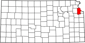 Map of Kansas highlighting Leavenworth County | |
| Unincorporated communities | ||
| Ghost town | ||
| Townships |
| |
| Footnotes | ‡This community also has portions in an adjacent county or counties. | |
Kansas City metropolitan area's cities and counties | ||
|---|---|---|
| Central city | 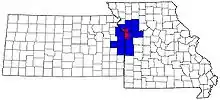 | |
| Largest cities (over 100,000 in 2000) | ||
| Medium-sized cities (10,000 to 100,000 in 2000) | ||
| Smaller cities (between 5,000 and 9,900 in 2010) | ||
| Counties | ||