Tornado outbreak sequence of June 20–26, 2023
On June 20, a sequence of multiple severe weather events and tornado outbreaks began across large portions of the Great Plains, Midwestern, and Eastern United States as well as Manitoba and Ontario in Canada near the country borders. This includes the “historic” tornado outbreak on June 21.[5] A slow moving trough interacted with extremely high moisture and atmospheric instability to produce favorable conditions for supercells. Large hail and damaging winds accompanied a multi-day tornado risk which produced multiple strong tornadoes, including a catastrophic high-end EF3 tornado in Matador, Texas on June 21,[1] and another high-end EF3 tornado south of Granada, Colorado on June 23, and multiple EF2 tornadoes from Indiana to Kentucky on June 25. Reports of power outages, wind damage, hail damage, and tornadic damage accumulated across the affected region. In all, five people died from tornadoes, and three other non-tornadic deaths also occurred. Over 120 people were injured as well.
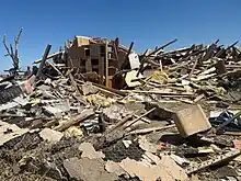 Damage to a home well south of Granada, Colorado caused by an EF3 tornado on June 23 | |
| Tornado outbreak | |
|---|---|
| Tornadoes | 113 |
| Maximum rating | EF3 tornado |
| Duration | June 20–26, 2023 |
| Highest winds | 165 mph (266 km/h) (Matador, Texas EF3 on June 21)[1] 125 mph (201 km/h) near Selfridge, North Dakota (downburst June 21)[2] |
| Largest hail | 4.5 in (11 cm) near Matador, Texas, on June 21 and near Lubbock, Texas, on June 23 |
| Overall effects | |
| Fatalities | 5 fatalities (+4 non-tornadic) |
| Injuries | >126 injuries |
| Damage | $3.3 billion (2023 USD)[3] |
| Areas affected | Great Plains, Midwestern, Eastern United States, Manitoba, Ontario |
| Power outages | 700,000[4] |
Part of the tornado outbreaks of 2023 | |
Meteorological synopsis
On the heels of another tornado outbreak, a second multi-day tornado outbreak began on June 20. On June 21, strong southwesterly winds associated with a large upper-level trough over the Western United States began overspreading central portions of the country. The Storm Prediction Center (SPC) issued a bimodal level 3/Enhanced risk, one encompassing the tri-state region of Wyoming, Colorado, and Nebraska, and the second stretching from the Texas/Oklahoma panhandles into North Texas. To the south, an extraordinarily moist environment with dewpoints in the mid-70s °F over the spread area.[6] High moisture combined with daytime heating resulted in an unstable airmass characterized by mixed-layer convective available potential energy (CAPE) in excess of 4,500 J/kg. Favorable wind shear overspread this environment, while the combination of outflow from morning storms and a nearby dry line became the focal point for thunderstorm development.[7] A broken line of supercells developed from Kansas southward into Texas, contributing to large hail, damaging winds, and a few tornadoes. An especially intense tornado moved through western sections of Matador, Texas, killing four people and causing significant damage. To the north across Colorado, Wyoming, and Nebraska, storms similarly developed along remnant outflow. Although low-level shear was weak, this outflow enhanced shear in the immediate vicinity of storms,[8] resulting in numerous, mainly brief tornadoes over largely open country.[9] A less active day occurred on June 22, although sporadic severe weather occurred across the Southern Plains, including a few brief tornado touchdowns in Colorado and Wyoming.[10]
On June 23, the focal point for active weather shifted northward into eastern Wyoming and The Dakotas, where the SPC outlined a level 3/Enhanced risk.[11] Stronger wind shear associated with an approaching shortwave trough overspread an unstable airmass with mixed-layer CAPE upwards of 2,500 J/kg. Through the afternoon, convection developed along the Laramie and Bighorn mountains, and along a warm front/outflow boundary across Wyoming and Nebraska.[12] A few supercells evolved in this region, particularly later into the afternoon as low-level shear increased, producing large hail and numerous tornadoes.[13] With time, outflow from ongoing convection merged, leading to a line of storms that pushed eastward.[14] Farther south in southeastern Colorado and western Kansas, more isolated but significant supercells developed along a dryline and in an area of strong orographic lift. These highly structured cells moved east in a favorable environment, producing large hail and long-lived, photogenic tornadoes.[15] On June 24, the risk area shifted deeper into the Midwestern United States.[16] A low-pressure area tracked across southeastern North Dakota during the afternoon, supporting a warm front across northern Minnesota. Modest CAPE of 1,500 J/kg combined with strong shear along the boundary fostered low-topped convection and multiple tornadoes,[17] including a strong tornado. To the south, combined clusters of convection produced sporadic damaging winds across Iowa and Illinois.[18]
An expansive level 3/Enhanced risk encompassed much of the Ohio River Valley and Mid-South on June 25. The greatest threat for potentially strong tornadoes was focused across Indiana, Ohio, and Kentucky.[19] Here, the environment rapidly destabilized amid daytime heating, CAPE upwards of 2,000 J/kg, and the approach of an upper-level trough. An arcing band of supercells quickly developed by midday along a pseudo-dryline feature,[20][21] producing very large hail and multiple strong tornadoes.[22] To the north across Michigan, a line of convection in a more marginal environment produced sporadic damaging winds.[23] Across the Southeastern United States, a moist and unstable environment devoid of strong low-level shear aided a long-lived mesoscale convective system that produced widespread damaging winds as well.[24] Multiple rounds of linear convection contributed to additional severe reports through the evening.[25] The threat for severe weather shifted eastward into the Mid-Atlantic on June 26, where the SPC issued a broad level 3/Enhanced risk stretching from The Carolinas into Pennsylvania and New Jersey.[26] An area of low pressure moved across Michigan and supported a cold front across the Ohio River Valley. To the east, a pre-frontal trough also developed along the Blue Ridge Mountains. Mixed-layer CAPE of 1,000-2,500 J/kg and dewpoints in excess of 65 °F (18 °C) across a wide region were forecast to materialize. However, diurnal heating was at least somewhat hampered by multiple rounds of convection and widespread cloudiness through the morning hours.[27] Clusters of storms developed throughout the region ahead of the cold front,[28] contributing to numerous instances of damaging wind reports until they began to weaken with the loss of daytime heating or pushed offshore the coastline.[29][30][31]
Confirmed tornadoes
| EFU | EF0 | EF1 | EF2 | EF3 | EF4 | EF5 | Total |
|---|---|---|---|---|---|---|---|
| 62 | 19 | 20 | 10 | 2 | 0 | 0 | 113 |
June 20 event
| EF# | Location | County / Parish | State | Start Coord. | Time (UTC) | Path length | Max width |
|---|---|---|---|---|---|---|---|
| EF1 | NNE of Carpenter (ND) to William Lake Provincial Park (MB) | Rolette (ND), Morton (MB) | ND, MB | 48.9983°N 99.9603°W | 02:35 | ≥4.0 mi (6.5 km) | ≥230 yd (210 m) |
| Aerial surveys revealed a tornado touched down just south of the Canada–United States border and moved northeast into Canada. Damage was confined to trees. Only the Canadian portion of the track was surveyed.[32][33] | |||||||
| EF1 | NW of Killarney to SE of Ninette | — | MB | 49.2331°N 99.748°W | 02:55 | 10.9 mi (17.5 km) | 1,300 yd (1,200 m) |
| A large tornado was confirmed through aerial surveys; details pending.[32][33] | |||||||
| EF1 | NE of MacGregor | — | MB | 49.9906°N 98.6987°W | 04:30 | 4.2 mi (6.8 km) | 870 yd (800 m) |
| Trees and grain bins were damaged.[32][33] | |||||||
June 21 event
| EF# | Location | County / Parish | State | Start Coord. | Time (UTC) | Path length | Max width |
|---|---|---|---|---|---|---|---|
| EFU | ENE of Lorenzo | Cheyenne | NE | 41.0583°N 103.0234°W | 19:33 | 0.59 mi (0.95 km) | 50 yd (46 m) |
| A local emergency manager observed a brief tornado.[34] | |||||||
| EFU | SSW of Padroni | Logan | CO | 40.7109°N 103.1988°W | 19:44–19:47 | 0.46 mi (0.74 km) | — |
| A storm chaser observed a tornado that caused no damage.[35] | |||||||
| EFU | SE of Akron | Washington | CO | 40.0657°N 102.9894°W | 21:05–21:10 | 0.67 mi (1.08 km) | — |
| A storm chaser observed a tornado over open fields.[36][35] | |||||||
| EFU | NNE of Pawnee Pass | Logan | CO | 40.0657|-102.9894|name=Pawnee Pass (Jun. 21, EFU)}}-->data-sort-value="" style="background: #ececec; color: #2C2C2C; vertical-align: middle; text-align: center; " class="table-na" | — | 21:35–21:46 | 1.5 mi (2.4 km) | — |
| Trained storm spotters observed a tornado.[35] | |||||||
| EFU | S of Akron (1st tornado) | Washington | CO | 39.9991°N 103.1896°W | 22:10–22:11 | 0.3 mi (0.48 km) | 25 yd (23 m) |
| A storm chaser observed a brief rope tornado over open fields.[35] | |||||||
| EFU | S of Claude | Armstrong | TX | 34.95°N 101.38°W | 22:18-22:23 | 0.97 mi (1.56 km) | 100 yd (91 m) |
| A tornado occurred over an open field.[36] | |||||||
| EFU | S of Akron (2nd tornado) | Washington | CO | 40.0207°N 103.2032°W | 22:18–22:22 | 0.51 mi (0.82 km) | 200 yd (180 m) |
| Storm chasers observed a cone tornado.[35] | |||||||
| EFU | S of Akron (3rd tornado) | Washington | CO | 40.0207|-103.2032|name=Elba (Jun. 21, EFU)}}-->data-sort-value="" style="background: #ececec; color: #2C2C2C; vertical-align: middle; text-align: center; " class="table-na" | — | 22:25–22:26 | 1 mi (1.6 km) | 50 yd (46 m) |
| Storm chasers observed a tornado.[35] | |||||||
| EFU | S of Akron (4th tornado) | Washington | CO | 40.0200°N 103.1971°W | 22:28–22:29 | 0.25 mi (0.40 km) | 50 yd (46 m) |
| A brief tornado occurred over open fields.[35] | |||||||
| EF2 | S of Akron (5th tornado) | Washington | CO | 40.0225°N 103.2085°W | 22:28–22:35 | 1.5 mi (2.4 km) | 400 yd (370 m) |
| Storm chasers observed a tornado that snapped power poles along SH 63.[35] | |||||||
| EFU | S of Akron (6th tornado) | Washington | CO | 40.0200|-103.1971|name=Elba (Jun. 21, EFU)}}-->data-sort-value="" style="background: #ececec; color: #2C2C2C; vertical-align: middle; text-align: center; " class="table-na" | — | 22:29–22:30 | 0.5 mi (0.80 km) | 50 yd (46 m) |
| A storm chaser reported a brief satellite tornado in association with the 4th tornado south of Akron.[35] | |||||||
| EFU | S of Akron (7th tornado) | Washington | CO | 40.0200|-103.1971|name=Elba (Jun. 21, EFU)}}-->data-sort-value="" style="background: #ececec; color: #2C2C2C; vertical-align: middle; text-align: center; " class="table-na" | — | 22:31–22:34 | 4 mi (6.4 km) | 50 yd (46 m) |
| A storm chaser reported a second, stronger satellite tornado in association with the 4th tornado south of Akron.[35] | |||||||
| EFU | S of Akron (8th tornado) | Washington | CO | 40.0200|-103.1971|name=Elba (Jun. 21, EFU)}}-->data-sort-value="" style="background: #ececec; color: #2C2C2C; vertical-align: middle; text-align: center; " class="table-na" | — | 22:36–22:37 | 0.5 mi (0.80 km) | — |
| A storm chaser observed another developing tornado.[35] | |||||||
| EFU | S of Akron (9th tornado) | Washington | CO | 40.0323°N 103.2387°W | 22:37–22:38 | 0.5 mi (0.80 km) | — |
| A storm chaser observed a tornado.[35] | |||||||
| EFU | S of Akron (10th tornado) | Washington | CO | 40.0329°N 103.2183°W | 22:39–22:40 | 0.25 mi (0.40 km) | — |
| A storm chaser observed a brief tornado over open fields.[35] | |||||||
| EFU | S of Akron (11th tornado) | Washington | CO | 40.0363°N 103.2269°W | 22:40–22:41 | 0.57 mi (0.92 km) | — |
| A storm chaser observed a brief tornado over open fields.[35] | |||||||
| EFU | S of Akron (12th tornado) | Washington | CO | 40.0363|-103.2269|name=Akron (Jun. 21, EFU)}}-->data-sort-value="" style="background: #ececec; color: #2C2C2C; vertical-align: middle; text-align: center; " class="table-na" | — | 22:42–22:43 | 0.25 mi (0.40 km) | — |
| A storm chaser observed a brief tornado.[35] | |||||||
| EF1 | S of Akron (13th tornado) | Washington | CO | 40.0422°N 103.2456°W | 22:43–22:45 | 0.95 mi (1.53 km) | 200 yd (180 m) |
| Damage was found at a farmstead; details unspecified.[36][35] | |||||||
| EFU | S of Akron (14th tornado) | Washington | CO | 40.0397°N 103.2202°W | 22:43–22:45 | 0.5 mi (0.80 km) | — |
| A storm chaser observed a large tornado.[35] | |||||||
| EFU | S of Akron (15th tornado) | Washington | CO | 40.0470°N 103.2400°W | 22:45–22:46 | 0.5 mi (0.80 km) | — |
| A brief tornado occurred over open fields.[35] | |||||||
| EFU | S of Akron (16th tornado) | Washington | CO | 40.0470°N 103.2249°W | 22:45–22:46 | 0.25 mi (0.40 km) | 50 yd (46 m) |
| A brief tornado occurred over open fields. This tornado occurred simultaneously with the preceding event.[35] | |||||||
| EFU | S of Akron (17th tornado) | Washington | CO | 40.0484°N 103.2352°W | 22:46–22:47 | 0.5 mi (0.80 km) | — |
| A storm chaser observed a brief tornado over open fields.[35] | |||||||
| EFU | S of Akron (18th tornado) | Washington | CO | 40.0484|-103.2352|name=Akron (Jun. 21, EFU)}}-->data-sort-value="" style="background: #ececec; color: #2C2C2C; vertical-align: middle; text-align: center; " class="table-na" | — | 22:47–22:48 | 0.5 mi (0.80 km) | — |
| A storm chaser observed another tornado.[35] | |||||||
| EFU | S of Akron (19th tornado) | Washington | CO | 40.0531°N 103.2361°W | 22:48–22:49 | 0.54 mi (0.87 km) | 100 yd (91 m) |
| A storm chaser observed a brief tornado over open fields.[35] | |||||||
| EFU | S of Akron (20th tornado) | Washington | CO | 40.0531|-103.2361|name=Akron (Jun. 21, EFU)}}-->data-sort-value="" style="background: #ececec; color: #2C2C2C; vertical-align: middle; text-align: center; " class="table-na" | — | 22:49–22:50 | 0.5 mi (0.80 km) | — |
| A storm chaser observed a large tornado.[35] | |||||||
| EFU | S of Akron (21st tornado) | Washington | CO | 40.0580°N 103.2490°W | 22:50–22:51 | 0.5 mi (0.80 km) | — |
| A storm chaser observed a brief tornado over open fields.[35] | |||||||
| EFU | S of Akron (22nd tornado) | Washington | CO | 40.0580|-103.2490|name=Akron (Jun. 21, EFU)}}-->data-sort-value="" style="background: #ececec; color: #2C2C2C; vertical-align: middle; text-align: center; " class="table-na" | — | 22:51–22:52 | 0.5 mi (0.80 km) | — |
| A storm chaser observed a new tornado.[35] | |||||||
| EFU | S of Akron (23rd tornado) | Washington | CO | 40.0580|-103.2490|name=Akron (Jun. 21, EFU)}}-->data-sort-value="" style="background: #ececec; color: #2C2C2C; vertical-align: middle; text-align: center; " class="table-na" | — | 22:52–22:55 | 2 mi (3.2 km) | 200 yd (180 m) |
| A storm chaser observed a new tornado.[35] | |||||||
| EFU | S of Akron (24th tornado) | Washington | CO | 40.0580|-103.2490|name=Akron (Jun. 21, EFU)}}-->data-sort-value="" style="background: #ececec; color: #2C2C2C; vertical-align: middle; text-align: center; " class="table-na" | — | 22:53–22:56 | 0.5 mi (0.80 km) | — |
| A storm chaser observed a new tornado occurring simultaneously to the previous entry.[35] | |||||||
| EFU | S of Akron (25th tornado) | Washington | CO | 40.0632°N 103.2495°W | 22:57–23:10 | — | 400 yd (370 m) |
| A storm chaser observed a large multi-vortex tornado over open fields.[35] | |||||||
| EFU | S of Akron (26th tornado) | Washington | CO | 40.0756°N 103.2455°W | 23:15–23:19 | 1 mi (1.6 km) | 50 yd (46 m) |
| A storm chaser observed a brief cone tornado over open fields.[35] | |||||||
| EF2 | S of Akron (27th tornado) | Washington | CO | 40.0952°N 103.3080°W | 23:20–23:36 | 3 mi (4.8 km) | 400 yd (370 m) |
| A barn and grain bins were destroyed and power poles were snapped.[35] | |||||||
| EF1 | NE of Willard | Logan | CO | 40.5737°N 103.4509°W | 23:30–23:40 | 0.25 mi (0.40 km) | 15 yd (14 m) |
| A brief tornado tore a large portion of a roof from a home and caused its chimney to collapse.[36][35] | |||||||
| EFU | W of Woodward | Washington | CO | 39.9866°N 103.4327°W | 23:39–23:53 | — | — |
| A storm chaser observed a tornado.[35] | |||||||
| EFU | N of Anton (1st tornado) | Washington | CO | 39.83°N 103.21°W | 00:14–00:15 | 0.71 mi (1.14 km) | 50 yd (46 m) |
| Storm chasers observed a brief anticyclonic tornado.[35] | |||||||
| EF2 | NW of Anton | Washington | CO | 39.8654°N 103.2302°W | 00:16–00:22 | 4.94 mi (7.95 km) | 800 yd (730 m) |
| A multiple-vortex tornado snapped 15 wooden power poles.[36][35] | |||||||
| EFU | N of Anton (2nd tornado) | Washington | CO | 39.8711°N 103.1946°W | 00:35–00:40 | 1 mi (1.6 km) | 50 yd (46 m) |
| A trained spotter observed a brief cone tornado.[35] | |||||||
| EFU | NNW of Anton | Washington | CO | 39.83°N 103.25°W | 00:45–01:00 | 1.02 mi (1.64 km) | — |
| A trained spotter observed a tornado.[35] | |||||||
| EFU | NE of Whiteflat | Motley | TX | 34.12°N 100.85°W | 00:50–00:51 | 0.18 mi (0.29 km) | 30 yd (27 m) |
| Storm chasers reported a brief tornado over open country. It did not cause damage."Storm Events Database". Retrieved 18 September 2023.</ref> | |||||||
| EF3 | NE of Whiteflat to Matador | Motley | TX | 34.12°N 100.85°W | 00:51–01:09 | 9.14 mi (14.71 km) | 600 yd (550 m) |
| 4 deaths – See section on this tornado – 15 people were injured. | |||||||
| EF0 | SE of Lemmon | Perkins | SD | 45.8581°N 102.0424°W | 01:19–01:21 | 1.76 mi (2.83 km) | 50 yd (46 m) |
| A tornado briefly occurred. No damage was reported.[37] | |||||||
| EFU | NE of Afton | Dickens | TX | 33.82°N 100.73°W | 01:36–01:37 | 0.06 mi (0.097 km) | 30 yd (27 m) |
| An off-duty NWS employee reported a brief tornado over open country. It did not cause damage.[38] | |||||||
| EFU | WSW of Matador | Motley | TX | 34.01°N 100.89°W | 01:37–01:40 | 2.82 mi (4.54 km) | 100 yd (91 m) |
| Local media streamed footage of a tornado. It did not cause damage.[39] | |||||||
| EFU | SW of Yoder | Goshen | WY | 41.886°N 104.344°W | 01:44–01:46 | 1.01 mi (1.63 km) | 50 yd (46 m) |
| A trained spotter reported a stovepipe tornado before it quickly became rain-wrapped.[40] | |||||||
| EFU | E of Dickens | Dickens | TX | 33.62°N 100.72°W | 02:18–02:19 | 0.35 mi (0.56 km) | 50 yd (46 m) |
| A storm chaser reported a brief tornado. It did not cause damage.[41] | |||||||
June 22 event
| EF# | Location | County / Parish | State | Start Coord. | Time (UTC) | Path length | Max width |
|---|---|---|---|---|---|---|---|
| EF1 | Kinston | Lenoir | NC | 35.285°N 77.586°W | 17:04–17:05 | 0.7 mi (1.1 km) | 100 yd (91 m) |
| At least six large windows at a Furniture Fair were bowed in or blown out. A large AC unit on the top of the store was blown off. A wooden power pole was snapped in half about 6 feet (1.8 m) off the ground. The eastern side of a Salvation Army store was bowed out. A nearby dumpster was blown about 100 yards (91 m). Some homes were damaged, and multiple trees were snapped. The tornado impacted UNC Health Care Lenoir, damaging an entrance sign and causing damage to a large section of a medical building's roof.[42] | |||||||
| EF1 | NW of Allison | Hemphill | TX | 35.7°N 100.23°W | 20:41–20:55 | 10.3 mi (16.6 km) | 150 yd (140 m) |
| This tornado moved through rural areas north of Allison. Many trees were snapped or uprooted along its path. Two silos had their lids torn off, resulting in one of them collapsing. Two sheds and a barn had minor roof damage.[43] | |||||||
| EF1 | Highlands Ranch to SW of Lone Tree | Douglas | CO | 39.5559°N 105.0159°W | 21:24–21:48 | 6.3 mi (10.1 km) | 25 yd (23 m) |
| A few homes were damaged, and several trees were downed.[44] | |||||||
| EFU | S of Chugwater | Laramie | WY | 41.653°N 104.8794°W | 22:42–22:45 | 3.12 mi (5.02 km) | 50 yd (46 m) |
| A tornado briefly touched down doing no known damage.[45] | |||||||
| EF0 | SSE of Peyton | El Paso | CO | 38.95°N 104.42°W | 02:08–02:10 | 0.85 mi (1.37 km) | 10 yd (9.1 m) |
| A cone tornado was confirmed; damage is unspecified.[46] | |||||||
June 23 event
| EF# | Location | County / Parish | State | Start Coord. | Time (UTC) | Path length | Max width |
|---|---|---|---|---|---|---|---|
| EF0 | N of Grace | Caribou | ID | 42.6424°N 111.72°W | 18:30–18:40 | 0.2 mi (0.32 km) | 10 yd (9.1 m) |
| Several photographs were shared of a weak tornado in an open field.[47] | |||||||
| EF0 | NE of Grainger | Sweetwater | WY | 41.6721°N 109.8193°W | 19:35–19:37 | 1.55 mi (2.49 km) | 30 yd (27 m) |
| A video showed a landspout over open country.[48] | |||||||
| EF0 | N of Natrona | Natrona | WY | 43.2326°N 106.82°W | 20:37–20:40 | 2.21 mi (3.56 km) | 30 yd (27 m) |
| A rope tornado occurred over open country causing no damage.[49] | |||||||
| EF0 | N of Kaycee | Johnson | WY | 43.7345°N 106.65°W | 20:40–20:41 | 0.53 mi (0.85 km) | 40 yd (37 m) |
| A rancher reported a brief tornado[50] | |||||||
| EF1 | SSW of Midwest to ESE of Edgerton | Natrona | WY | 43.2997°N 106.3486°W | 21:15–21:25 | 10.83 mi (17.43 km) | 100 yd (91 m) |
| A cone tornado overturned a trailer, blew fuel tanks away and damaged trees.[51] | |||||||
| EFU | ESE of Ross | Converse | WY | 43.43°N 105.84°W | 22:33 | 0.25 mi (0.40 km) | 50 yd (46 m) |
| A brief tornado occurred.[52] | |||||||
| EFU | ENE of Chugwater (1st tornado) | Platte | WY | 41.7745°N 104.7474°W | 23:11 | 0.01 mi (0.016 km) | 50 yd (46 m) |
| A tornado touched down for 21 seconds before lifting; no damage occurred.[53] | |||||||
| EFU | ENE of Chugwater (2nd tornado) | Goshen | WY | 41.794°N 104.646°W | 23:29–23:37 | 3 mi (4.8 km) | 50 yd (46 m) |
| Numerous photos and videos showed a cone tornado over open country with no damage reported.[54] | |||||||
| EF2 | North Antelope Rochelle Mine to WSW of Rochelle | Campbell, Weston | WY | 43.4986°N 105.3563°W | 23:59–01:20 | 9.81 mi (15.79 km) | 800 yd (730 m) |
| A strong tornado touched down along the Campbell/Converse County Line, snapping wooden power poles in the area. It moved northeast and struck the North Antelope Rochelle Mine, the largest coal mine in the world. Twelve cars on an empty train were knocked over and eight employees were injured. The operations area was directly impacted; metal roofing was torn from buildings and buses, cars, and shipping containers were flipped. the tornado continued into Weston County blowing down trees and ripping off part of a roof on a house before lifting.[55][56] | |||||||
| EFU | W of Hawk Springs | Goshen | WY | 41.7728°N 104.4151°W | 00:03–00:04 | 0.5 mi (0.80 km) | 50 yd (46 m) |
| Storm spotters shared many photos and videos of a brief tornado over open country.[57] | |||||||
| EF2 | S of Hawk Springs | Goshen | WY | 41.7762°N 104.2608°W | 00:21–00:37 | 4.72 mi (7.60 km) | 800 yd (730 m) |
| Trained spotters observed this rain-wrapped tornado. An 18-wheeler was flipped along US 85, injuring the driver.[58] An irrigation pivot was partially ripped from its concrete base. Numerous power poles were snapped, and one home had a tree branch impaled into its siding near US 85.[59] | |||||||
| EF1 | SE of Campo to W of Elkhart, KS | Baca | CO | 37.03°N 102.33°W | 00:33–00:56 | 8.43 mi (13.57 km) | 100 yd (91 m) |
| A long-lived tornado remained over mostly barren terrain. Two structures at an abandoned farmstead were damaged and power poles were downed.[60] | |||||||
| EF3 | SSW of Granada | Prowers | CO | 37.9756°N 102.388°W | 00:40–01:22 | 13.12 mi (21.11 km) | 320 yd (290 m) |
| This intense tornado remained largely over open countryside, impacting a few farms along its path. Early in its track, it obliterated two wooden barns and one steel barn with hardly any debris remaining from all of them. The farmstead's home was almost completely leveled, with only one interior wall left standing. Eight cattle were killed on the farm. The tornado moved southeast from the farm and downed two power poles before dissipating over open fields. This was the strongest tornado to impact Colorado since an EF3 tornado that struck Berthoud on June 4, 2015.[61][62][63] | |||||||
| EF1 | E of Hawk Springs | Goshen | WY | 41.78°N 104.14°W | 00:44–00:58 | 3.9 mi (6.3 km) | 20 yd (18 m) |
| Third and final tornado near Hawk Springs. A few light poles and flag poles were bent.[64] | |||||||
| EFU | W of Gering | Scotts Bluff | NE | 41.821°N 103.938°W | 01:04–01:11 | 3.53 mi (5.68 km) | 50 yd (46 m) |
| A tornado occurred over open fields near Gunsight Pass.[65] | |||||||
| EFU | W of Gering | Scotts Bluff | NE | 41.85°N 103.85°W | 01:22–01:27 | 3.16 mi (5.09 km) | 50 yd (46 m) |
| Storm spotters observed a tornado that became rain-wrapped over open fields near Rifle Sight Pass.[66] | |||||||
| EF2 | E of Gering to SE of Scottsbluff | Scotts Bluff | NE | 41.82°N 103.63°W | 01:38–01:45 | 2.48 mi (3.99 km) | 700 yd (640 m) |
| A multiple-vortex tornado originated near the North Platte River and moved northeast, prompting a tornado emergency. It severely damaged a home, scattering debris up to 0.5 mi (0.80 km) away, before reversing direction and moving near the same areas. It passed over wastewater treatment ponds, sucking water from them, before dissipating. Power poles were snapped, and irrigation pivots were overturned. One person was injured in a flipped vehicle.[67] | |||||||
| EF0 | N of Johnson City | Stanton | KS | 37.67°N 101.75°W | 01:40 | 0.01 mi (0.016 km) | 1 yd (0.91 m) |
| A storm chaser reported a tornado.[68] | |||||||
| EF1 | SE of Gering | Scotts Bluff | NE | 41.81°N 103.62°W | 01:44–01:47 | 1.24 mi (2.00 km) | 50 yd (46 m) |
| A diffuse tornado collapsed a quonset and snapped power poles.[69] | |||||||
| EFU | ESE of Gering | Scotts Bluff | NE | 41.81°N 103.59°W | 01:50 | 0.5 mi (0.80 km) | 50 yd (46 m) |
| A trained spotter reported a rain-wrapped tornado.[70] | |||||||
| EFU | W of Minatare | Scotts Bluff | NE | 41.82°N 103.54°W | 02:05 | 0.5 mi (0.80 km) | 50 yd (46 m) |
| A trained spotter reported a tornado.[71] | |||||||
| EF0 | NE of Johnson City | Stanton | KS | 37.64°N 101.56°W | 02:09 | 0.01 mi (0.016 km) | 1 yd (0.91 m) |
| A storm chaser reported a tornado.[72] | |||||||
| EF0 | WNW of Ulysses | Grant | KS | 37.62°N 101.49°W | 02:12 | 4.21 mi (6.78 km) | 1 yd (0.91 m) |
| The public reported a tornado.[73] | |||||||
| EFU | E of Lynn | Morrill | NE | 41.81°N 102.85°W | 03:51 | 0.5 mi (0.80 km) | 50 yd (46 m) |
| A storm chaser reported a brief tornado.[74] | |||||||
June 24 event
| EF# | Location | County / Parish | State | Start Coord. | Time (UTC) | Path length | Max width |
|---|---|---|---|---|---|---|---|
| EFU | N of Lake Park (1st tornado) | Becker | MN | 46.9710°N 96.0987°W | 20:20–20:23 | 1.98 mi (3.19 km) | — |
| Local broadcast media photographed a tornado;[75] no damage occurred.[36] | |||||||
| EFU | NW of Borup | Norman | MN | 47.2474°N 96.5981°W | 20:25–20:30 | 2.35 mi (3.78 km) | — |
| A trained spotter observed a tornado;[76] no damage occurred.[36] | |||||||
| EFU | W of Waubun | Mahnomen | MN | 47.1883°N 96.0597°W | 20:54 | — | — |
| A brief tornado touched down without causing damage.[36] | |||||||
| EFU | S of Waubun | Mahnomen | MN | 47.1588°N 95.9469°W | 21:03 | — | — |
| A brief tornado touched down for 30 seconds.[36] | |||||||
| EFU | NE of Shelly | Norman, Polk | MN | 47.4946°N 96.734°W | 21:10–21:16 | 1.45 mi (2.33 km) | — |
| A tornado touched down without causing damage.[36] | |||||||
| EF0 | SW of Lockhart | Norman | MN | 47.4061°N 96.5992°W | 21:12–21:15 | 2.03 mi (3.27 km) | 20 yd (18 m) |
| A brief tornado damaged trees in a shelterbelt.[36][77] | |||||||
| EF2 | E of Mahnomen | Mahnomen | MN | 47.2542°N 95.9378°W | 21:15–21:40 | 7 mi (11 km) | 250 yd (230 m) |
| An intermittent multiple vortex tornado damaged three farmsteads and two power poles. East of Mahnomen, a home had its roof completely torn off and a Quonset hut caved in. A garage shed collapsed and was shifted from its foundation. Multiple trees were snapped or uprooted.[36][78] | |||||||
| EFU | NW of Lockhart | Norman | MN | 47.5498°N 96.6392°W | 21:25 | — | — |
| A brief tornado touched down over open fields.[36] | |||||||
| EFU | N of Lake Park (2nd tornado) | Becker | MN | 47.1293°N 96.0770°W | 21:36 | — | — |
| A brief tornado touched down without causing damage.[36] | |||||||
| EFU | WNW of Beltrami | Polk | MN | 47.5498°N 96.6392°W | 21:44 | — | — |
| A brief tornado touched down over open fields.[36] | |||||||
| EFU | NW of Beltrami (1st tornado) | Polk | MN | 47.5757°N 96.6085°W | 21:49–21:52 | 0.99 mi (1.59 km) | — |
| A tornado moved through open fields.[36] | |||||||
| EFU | WNW of Beltrami (2nd tornado) | Polk | MN | 47.5683°N 96.6431°W | 21:52 | — | — |
| A brief tornado touched down over open fields.[36] | |||||||
| EF0 | S of Maysville to ESE of Eldridge | Scott | IA | 41.6041°N 90.7113°W | 03:31–03:45 | 9.63 mi (15.50 km) | 20 yd (18 m) |
| A small tornado caused sporadic tree and structural damage across its path, including at Davenport Airport.[79] | |||||||
| EF0 | N of Pocahontas to SW of Rolfe | Pocahontas | IA | 42.7772°N 94.6547°W | 04:02–04:07 | 2.77 mi (4.46 km) | 80 yd (73 m) |
| A tornado moved a grain bit off its foundation and rolled it into a field.[80] | |||||||
June 25 event
| EF# | Location | County / Parish | State | Start Coord. | Time (UTC) | Path length | Max width |
|---|---|---|---|---|---|---|---|
| EF2 | NW of Bargersville to W of New Whiteland | Johnson | IN | 39.5692°N 86.221°W | 20:13–20:23 | 5.4 mi (8.7 km) | 400 yd (370 m) |
| A strong tornado touched down northwest of Bargersville and quickly produced significant damage as it moved east. A home had bricks and part of its roof torn off and a trailer was blown into a neighboring property. The tornado then moved through the Kensington Grove subdivision and Waters Edge neighborhood where multiple homes had significant roof damage. East of there, an apartment building under construction had its entire roof shorn away with debris embedded in the ground. Thereafter, the tornado turned southeast and caused scattered tree damage before dissipating. Many trees and power poles were snapped along the path.At least 75 homes were damaged in the Bargersville area.[81][82] | |||||||
| EF1 | S of Crane | Daviess, Martin | IN | 38.887°N 86.958°W | 20:21–20:30 | 3.73 mi (6.00 km) | 100 yd (91 m) |
| A brief tornado downed trees in the Naval Surface Warfare Center Crane Division area.[83][84] | |||||||
| EF1 | NW of Oolitic | Monroe | IN | 39.0287°N 86.6745°W | 20:30–20:37 | 4.45 mi (7.16 km) | 100 yd (91 m) |
| One home suffered extensive roof damage. One other home and multiple outbuildings were damaged to lesser degrees. Many trees were snapped or uprooted along the tornado's path.[85] | |||||||
| EF2 | ENE of Alfordsville to Rusk to W of Hillham | Martin, Dubois | IN | 38.585°N 86.8666°W | 20:34–20:46 | 9.12 mi (14.68 km) | 565 yd (517 m) |
| 1 death – This strong tornado impacted northwestern areas of Hoosier National Forest. Near the touchdown point, a two-car garage was destroyed, and a home had its roof partially torn off. Within Hoosier National Forest in the community of Rusk, the top floor of a two-story cabin was completely destroyed after winds from the tornado lifted the adjoining patio and caused the structure to collapse. Only one exterior wall was left standing. One person was killed, and another was injured in the home. Several outbuildings at another property were destroyed. Numerous trees were snapped or uprooted throughout its path.[86][87] | |||||||
| EF1 | ENE of Dover | Pope | AR | 35.4178°N 93.0723°W | 21:19–21:20 | 0.6 mi (0.97 km) | 50 yd (46 m) |
| A brief tornado uprooted trees.[88] | |||||||
| EFU | Camp Robinson | Pulaski | AR | 34.9199°N 92.3054°W | 22:37–22:38 | 0.2 mi (0.32 km) | 50 yd (46 m) |
| A tornado was photographed over a heavily forested area of Camp Robinson, however it was non-surveyable due to widespread wind damage in the area.[89] | |||||||
| EF0 | Western Windsor | Essex | ON | 42.2903°N 83.0542°W | 22:45 | 1.26 mi (2.02 km) | 200 yd (180 m) |
| A brief, dusty tornado caused minor tree damage.[32] | |||||||
| EF0 | Eastern Windsor to Tecumseh | Essex | ON | 42.3057°N 82.9091°W | 23:00 | 2.91 mi (4.69 km) | 130 yd (120 m) |
| A narrow tornado caused minor damage to several homes and trees.[32] | |||||||
| EF2 | W of Cecilia | Hardin | KY | 37.682°N 86.0133°W | 02:27–02:32 | 1.17 mi (1.88 km) | 300 yd (270 m) |
| A brief but strong tornado caused extensive damage to a few homes and snapped or uprooted multiple trees. One home had its porch and part of its roof torn away. A carport at another home was hurled. Two vehicles were shifted, and a RV was knocked over.[90] | |||||||
| EF1 | SW of Jamestown | Russell | KY | 36.9757°N 85.0861°W | 04:25–04:26 | 0.67 mi (1.08 km) | 300 yd (270 m) |
| A brief tornado snapped or uprooted multiple trees and caused minor roof damage to several structures.[91] | |||||||
June 26 event
| EF# | Location | County / Parish | State | Start Coord. | Time (UTC) | Path length | Max width |
|---|---|---|---|---|---|---|---|
| EF0 | ENE of Martins Creek | Northampton | PA | 40.7904°N 75.1453°W | 18:58–19:04 | 3.37 mi (5.42 km) | 60 yd (55 m) |
| A tornado moved through wheat fields, causing minor damage to the crops.[92] | |||||||
| EF0 | S of Clearview | Simcoe | ON | 44.3857°N 80.1035°W | 19:20 | 1.75 mi (2.82 km) | 130 yd (120 m) |
| A short-lived tornado caused minor damage to homes, fences, trees, and crops.[32] | |||||||
| EF1 | Bernardsville | Somerset | NJ | 40.7109°N 74.5804°W | 19:29–19:34 | 1.38 mi (2.22 km) | 475 yd (434 m) |
| A brief tornado snapped or uprooted numerous trees, some of which fell on cars and power lines. Large trees were snapped at their trunk; however, analysis determined them to not be healthy, preventing a higher damage rating.[93] | |||||||
| EF0 | SSW of Tweed | Tweed | ON | 44.4531°N 77.3223°W | 20:35 | 3.81 mi (6.13 km) | 490 yd (450 m) |
| A weak tornado moved along the western side of Stoco Lake.[32] | |||||||
| EF0 | NE of Tweed | Tweed | ON | 44.4911°N 77.2735°W | 20:45 | 2.04 mi (3.28 km) | 260 yd (240 m) |
| A weak tornado touched down near where the first Tweed tornado dissipated along the northern end of Stoco Lake.[32] | |||||||
| EF1 | W of Albin | Laramie | WY | 41.411°N 104.339°W | 00:42–00:50 | 3.57 mi (5.75 km) | 1,000 yd (910 m) |
| One home was damaged and an outbuilding was destroyed with debris strewn hundreds of yards away. Hay bales weighing up to 1,400 lb (640 kg) were moved up to 0.5 mi (0.80 km). Near the tornado's terminus, eight old wooden power poles were snapped.[94] | |||||||
| EF1 | SW of Albin | Laramie | WY | 41.365°N 104.28°W | 00:52–01:05 | 3.55 mi (5.71 km) | 1,000 yd (910 m) |
| A large tornado snapped eleven wooden power poles.[95] | |||||||
| EF0 | SSE Albin | Laramie | WY | 41.316°N 104.061°W | 01:18 | 0.1 mi (0.16 km) | 50 yd (46 m) |
| A brief tornado overturned an irrigation pivot.[96] | |||||||
| EF1 | SW of Kimball | Kimball | NE | 41.194°N 103.758°W | 02:01–02:05 | 1.56 mi (2.51 km) | 100 yd (91 m) |
| A rope tornado tracked over largely open field south of I-80. One farmstead was impacted, with a cinderblock outbuilding destroyed and debris tossed 50 yd (46 m). A shipping container was shifted off its foundation and a 20,000 lb (9,100 kg) tandem-disk plow was moved 15 ft (4.6 m).[97] | |||||||
| EFU | S of Kimball | Kimball | NE | 41.2°N 103.66°W | 02:29 | 0.5 mi (0.80 km) | 50 yd (46 m) |
| An NWS Employee observed a brief tornado.[98] | |||||||
Matador, Texas
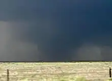 The tornado photographed by Tim Marshall | |
| Meteorological history | |
|---|---|
| Duration | 18 minutes |
| Formed | June 21, 2023, 7:51 p.m. CDT (UTC−05:00) |
| Dissipated | June 21, 2023, 8:09 p.m. CDT (UTC−05:00) |
| EF3 tornado | |
| on the Enhanced Fujita scale | |
| Highest winds | 165 mph (266 km/h) |
| Overall effects | |
| Casualties | 4 fatalities, 15 injuries[1] |
This intense tornado touched down in an open field north of Matador and initially tracked southeast, where it damaged a few light poles along FM 94. The tornado turned south-southeastward as it destroyed a house on the north side of Matador. Three vehicles from this residence were thrown hundreds of yards and two of the vehicles were never located. A large metal canopy was also destroyed, and trees near the residence were significantly debarked and uprooted. The tornado turned south through a field, producing minor ground scouring. Passing through the far western portion of the town, two homes were destroyed along SH 70. A truck was thrown over 200 feet from one home, and was mangled beyond recognition. Two homes near Pipkin St had their roofs torn off, and again extreme tree debarking was observed. The tornado then began to approach more populated areas of the town. A two story brick home with multiple outbuildings was completely swept away near Stewart Ave. The tornado began to track slightly southwest near the intersection of SH 70 and US 62/US 70. Several homes in this area were damaged, and several vehicles were rolled, including a tractor trailer. One home in this area was completely destroyed, and partially swept from its foundation. As the tornado crossed US 62/US 70, significant damage occurred. A recently built, steel framed Dollar General was completely destroyed, with its anchoring bolts ripped from the concrete foundation. Concrete bollards at this location were snapped and torn from the ground as well. A semi-truck was torn from its chassis, killing the driver.[99] Multiple metal buildings were completely destroyed, and a small home was obliterated. Two convenience stores were damaged, and both a restaurant and motel were partially destroyed. One metal building was impacted with enough force to remove sections of its tiled floor. Trees in this area were again debarked, with some having their root balls torn out of the ground. A power substation near the Dollar General was partially collapsed, leaving 99% of the town without electricity.[100] The tornado then turned southeastward as it paralleled SH 70. A Ford Power Stroke engine was ripped out of a truck, and tossed into a pond. A home was destroyed and several others were significantly damaged, along with a large isolated metal building being completely swept off its foundation as the tornado began to start tracking southeast again.[36]
As the tornado then crossed SH 70, it destroyed a guyed 500 feet (150 m) tall radio tower and significantly damaged trees. A home to the east of the highway was completely destroyed, as well as surrounding light posts. Minimal ground scouring was also visible. From here the tornado began to weaken drastically. A single home and barn had minor damage before the tornado abruptly turned southeast dissipating in a nearby field. In total four people were killed and 15 others were injured by the tornado.[1] One of the four people killed by the tornado was first reported as injured and later died at a local hospital.[36][101][102][103][104]
Non-tornadic events
On June 21, a downburst produced estimated winds of 125 mph (201 km/h) near Selfridge, North Dakota. A manufactured home was completely destroyed with debris strewn downstream. One person was injured.[2]
Around 9:30 p.m. MDT, a hailstorm impacted the Red Rocks Amphitheatre in the Denver metropolitan area during a concert.[105] Hailstones up to 2 in (5.1 cm) in diameter pelted concertgoers and accumulated several inches deep in the stands.[106] Three acts were scheduled that night with the second being delayed 15 minutes prior to the storm's arrival. Attendees did not seek shelter until a warning to do so was given 3 minutes before the hail started.[107] Nearly 100 people were injured, with injuries ranging from cuts and bruises to broken bones,[106] as they were unable to get indoors or to their cars in time; 8 people required hospitalization. An employee described people as having panic attacks and other workers being frozen and unable to act. Numerous cars were damaged in the venue's parking lot.[107] Severe weather that night forced a Major League Soccer game between the Colorado Rapids and Vancouver Whitecaps to be postponed.[108] The storm also caused one fatality due to flooding in Arapahoe County, Colorado.[109]
The same supercell that produced the EF3 Matador tornado also produced destructive winds and hail, with gusts measured up to 109 mph (175 km/h) in Jayton and hailstones exceeding 4 in (10 cm) in diameter.[110] Sustained winds in Jayton were also measured up to 86 mph (138 km/h).[111] At least 900 people were left without power from the storm.[110] A powerful thunderstorm impacted the Greater Houston area, leaving roughly 324,000 customers without power.[112] A narrow area of hurricane-force winds impacted George Bush Intercontinental Airport where a record gust of 97 mph (156 km/h) was observed. This surpassed the airport's previous highest gust of 82 mph (132 km/h) during Hurricane Ike in 2008.[113]
On June 25, widespread damaging winds left almost 150,000 customers without power in Arkansas.[114] Two people were killed in Carlisle when a tree fell on their home and one person was injured in another incident.[115] Governor Sarah Huckabee Sanders declared a state of emergency on June 26.[114] Severe storms in Georgia left approximately 300,000 people without power. One person was killed in northern Atlanta when a tree fell on him. Two people were injured in Cherokee County. At Hartsfield-Jackson Atlanta International Airport, the storms prompted the cancellation of 86 flights and delayed an additional 57 flights. The combination of heavy rain and winds caused trees to fall at the North Georgia Wildlife Park in White County; several animal enclosures required repairs.[116] A macroburst impacted Madison County, Kentucky, with damage spanning an area 2.5 mi (4 km) wide and 8.4 mi (13.5 km) long. Maximum winds were estimated at 110 mph (180 km/h). Numerous trees were snapped or uprooted and many barns and homes suffered roof damage.[117] Winds of 90 to 100 mph (140 to 160 km/h) affected parts of Bullitt County.[118] Straight-line winds of 90 to 95 mph (145 to 153 km/h) impacted Floyd County, Indiana, with a barn having its roof torn off and thrown 150 yd (140 m) downstream.[119]
On June 26, heavy rain led to flash flooding in New Jersey, with rainfall peaking at 3.99 in (101 mm) in Paterson. Over 16,000 customers lost power due to the storms.[120] In the Lehigh Valley, rainfall totals were in the 2.5–5.5 in (64–140 mm) range, leading to 3,300 power outages.[121] Rainfall totals reached 4.71 in (120 mm) in the state of Delaware.[122] The storm led to over 500 flights delayed and 300 flights cancelled at Newark Liberty International Airport, as well as ground stops at both LaGuardia Airport and John F. Kennedy International Airport.[123] In total, over 7,000 flights were delayed due to severe weather, with 811 flights being cancelled, on June 26.[124] Flooding also resulted in U.S. Route 9 shutting down in Latham Circle.[125]
See also
Notes
- All dates are based on the local time zone where the tornado touched down; however, all times are in Coordinated Universal Time for consistency.
References
- National Centers for Environmental Information (18 September 2023). "Texas Event Report: EF3 Tornado (Motley County)". Storm Event Database. National Oceanic and Atmospheric Administration. Archived from the original on 18 September 2023. Retrieved 18 September 2023.
- "National Weather Service Surveyed Damage From June 21, 2023 in Sioux County North Dakota". National Weather Service Forecast Office in Bismarck, North Dakota. June 25, 2023. Retrieved June 25, 2023 – via Iowa Environmental Mesonet.
- Events: Billion-Dollar Weather and Climate Disasters, NOAA
- Almost 8,000 US flights delayed or canceled due to severe storms, CNN, June 26, 2023
- "Historic Tornado Event - June 21, 2023". National Weather Service of Boulder/Denver, Colorado. Retrieved 6 July 2023.
- John Hart; Brian Squitieri (June 21, 2023). "Jun 21, 2023 1630 UTC Day 1 Convective Outlook". Storm Prediction Center. Retrieved June 27, 2023.
- Steve Goss (June 21, 2023). "Mesoscale Discussion 1197". Storm Prediction Center. Retrieved June 27, 2023.
- Brian Squitieri (June 21, 2023). "Mesoscale Discussion 1191". Storm Prediction Center. Retrieved June 27, 2023.
- "SPC Storm Reports for 06/21/23". Storm Prediction Center. June 21, 2023. Retrieved June 27, 2023.
- "SPC Storm Reports for 06/22/23". Storm Prediction Center. June 22, 2023. Retrieved June 27, 2023.
- Jared Guyer; Aaron Gleason (June 23, 2023). "Jun 23, 2023 1630 UTC Day 1 Convective Outlook". Storm Prediction Center. Retrieved June 27, 2023.
- Aaron Gleason; Jared Guyer (June 23, 2023). "Mesoscale Discussion 1220". Storm Prediction Center. Retrieved June 27, 2023.
- "SPC Storm Reports for 06/23/23". Storm Prediction Center. June 23, 2023. Retrieved June 27, 2023.
- Andrew Lyons (June 23, 2023). "Mesoscale Discussion 1226". Storm Prediction Center. Retrieved June 27, 2023.
- "23 June 2023 Prowers and Baca Tornadoes". National Weather Service. June 26, 2023. Retrieved June 27, 2023.
- Jeremy Grams; Nathan Wendt (June 24, 2023). "Jun 24, 2023 1630 UTC Day 1 Convective Outlook". Storm Prediction Center. Retrieved June 27, 2023.
- Steve Goss (June 24, 2023). "Mesoscale Discussion 1246". Storm Prediction Center. Retrieved June 27, 2023.
- Steve Goss (June 24, 2023). "Mesoscale Discussion 1248". Storm Prediction Center. Retrieved June 27, 2023.
- Jeremy Grams; Brian Squitieri (June 25, 2023). "Jun 25, 2023 1630 UTC Day 1 Convective Outlook". Storm Prediction Center. Retrieved June 27, 2023.
- Aaron Gleason; Jeremy Grams (June 25, 2023). "Mesoscale Discussion 1252". Storm Prediction Center. Retrieved June 27, 2023.
- Aaron Gleason (June 25, 2023). "Mesoscale Discussion 1259". Storm Prediction Center. Retrieved June 27, 2023.
- "SPC Storm Reports for 06/25/23". Storm Prediction Center. June 25, 2023. Retrieved June 27, 2023.
- Aaron Gleason (June 25, 2023). "Mesoscale Discussion 1261". Storm Prediction Center. Retrieved June 27, 2023.
- Brian Squitieri; Jeremy Grams (June 25, 2023). "Mesoscale Discussion 1258". Storm Prediction Center. Retrieved June 27, 2023.
- Andrew Lyons (June 25, 2023). "Mesoscale Discussion 1271". Storm Prediction Center. Retrieved June 27, 2023.
- Jeremy Grams; Brian Squitieri (June 26, 2023). "Jun 26, 2023 1630 UTC Day 1 Convective Outlook". Storm Prediction Center. Retrieved June 27, 2023.
- Aaron Gleason; Jeremy Grams (June 26, 2023). "Mesoscale Discussion 1282". Storm Prediction Center. Retrieved June 27, 2023.
- Andrew Lyons (June 26, 2023). "Mesoscale Discussion 1292". Storm Prediction Center. Retrieved June 27, 2023.
- "SPC Storm Reports for 06/26/23". Storm Prediction Center. June 26, 2023. Retrieved June 27, 2023.
- Andrew Lyons (June 26, 2023). "Mesoscale Discussion 1296". Storm Prediction Center. Retrieved June 27, 2023.
- Steve Goss (June 26, 2023). "Mesoscale Discussion 1298". Storm Prediction Center. Retrieved June 27, 2023.
- "Interactive Open Data for the Northern Tornadoes Project". University of Western Ontario. Northern Tornadoes Project. 2023. Retrieved June 30, 2023.
- Hoye, Bryce (June 27, 2023). 3 tornadoes touched down during 'very intense' western Manitoba storms last week, experts say (Report). CBC News. Retrieved June 30, 2023.
- "Storm Events Database". Retrieved 18 September 2023.
- National Weather Service in Boulder, Colorado. Historic Tornado Event - June 21, 2023 (Report). National Weather Service. Retrieved July 7, 2023.
- "Damage Assessment Toolkit". National Oceanic and Atmospheric Administration.
- "Storm Events Database". Retrieved 18 September 2023.
- "Storm Events Database". Retrieved 18 September 2023.
- "Storm Events Database". Retrieved 18 September 2023.
- "Storm Events Database". Retrieved 18 September 2023.
- "Storm Events Database". Retrieved 18 September 2023.
- "Storm Events Database". Retrieved 18 September 2023.
- "Storm Events Database". Retrieved 18 September 2023.
- "Storm Events Database". Retrieved 18 September 2023.
- "Storm Events Database". Retrieved 18 September 2023.
- "Storm Events Database". Retrieved 18 September 2023.
- "Storm Events Database". Retrieved 18 September 2023.
- "Storm Events Database". Retrieved 18 September 2023.
- "Storm Events Database". Retrieved 18 September 2023.
- "Storm Events Database". Retrieved 18 September 2023.
- "Storm Events Database". Retrieved 18 September 2023.
- "Storm Events Database". Retrieved 18 September 2023.
- "Storm Events Database". Retrieved 18 September 2023.
- "Storm Events Database". Retrieved 18 September 2023.
- "Storm Events Database". Retrieved 18 September 2023.
- "Storm Events Database". Retrieved 18 September 2023.
- "Storm Events Database". Retrieved 18 September 2023.
- NWS Damage Survey for 06/23/2023 Tornado Event From Chugwater To Hawk Springs Wyoming and Gering Nebraska (Report). National Weather Service Forecast Office in Cheyenne, Wyoming. July 1, 2023. Retrieved July 2, 2023.
- "Storm Events Database". Retrieved 18 September 2023.
- "Storm Events Database". Retrieved 18 September 2023.
- "Storm Events Database". Retrieved 18 September 2023.
- Reppenhagen, Cory (June 25, 2023). "Colorado sees its strongest tornado since 2015". KUSA. Retrieved June 26, 2023.
- Dumas, Tyler (June 24, 2023). "Tornado in Prowers County destroys home and vehicles, kills cows". KRDO. Retrieved June 25, 2023.
- "Storm Events Database". Retrieved 18 September 2023.
- "Storm Events Database". Retrieved 18 September 2023.
- "Storm Events Database". Retrieved 18 September 2023.
- "Storm Events Database". Retrieved 18 September 2023.
- "Storm Events Database". Retrieved 18 September 2023.
- "Storm Events Database". Retrieved 18 September 2023.
- "Storm Events Database". Retrieved 18 September 2023.
- "Storm Events Database". Retrieved 18 September 2023.
- "Storm Events Database". Retrieved 18 September 2023.
- "Storm Events Database". Retrieved 18 September 2023.
- "Storm Events Database". Retrieved 18 September 2023.
- Preliminary Local Storm Report (Report). National Weather Service in Grand Forks, North Dakota. June 24, 2023. Retrieved June 25, 2023 – via Iowa Environmental Mesonet.
- Preliminary Local Storm Report (Report). National Weather Service in Grand Forks, North Dakota. June 24, 2023. Retrieved June 25, 2023 – via Iowa Environmental Mesonet.
- Preliminary Local Storm Report (Report). National Weather Service in Grand Forks, North Dakota. June 24, 2023. Retrieved June 25, 2023 – via Iowa Environmental Mesonet.
- NWS Damage Survey for 06/24/2023 Tornado Event (Report). National Weather Service Forecast Office in Grand Forks, North Dakota. June 26, 2023. Retrieved June 23, 2023 – via Iowa Environmental Mesonet.
- "Storm Events Database". Retrieved 18 September 2023.
- "Storm Events Database". Retrieved 18 September 2023.
- Albeck-Ripka, Livia; Twomey, Matt (June 26, 2023). "At Least 1 Dead After Tornadoes Are Reported in Indiana". The New York Times. Retrieved June 26, 2023.
- "Storm Events Database". Retrieved 18 September 2023.
- "Storm Events Database". Retrieved 18 September 2023.
- "Storm Events Database". Retrieved 18 September 2023.
- "Storm Events Database". Retrieved 18 September 2023.
- "Storm Events Database". Retrieved 18 September 2023.
- "Storm Events Database". Retrieved 18 September 2023.
- "Storm Events Database". Retrieved 18 September 2023.
- "Storm Events Database". Retrieved 18 September 2023.
- "Storm Events Database". Retrieved 18 September 2023.
- "Storm Events Database". Retrieved 18 September 2023.
- "Storm Events Database". Retrieved 18 September 2023.
- "Storm Events Database". Retrieved 18 September 2023.
- "Storm Events Database". Retrieved 18 September 2023.
- "Storm Events Database". Retrieved 18 September 2023.
- "Storm Events Database". Retrieved 18 September 2023.
- "Storm Events Database". Retrieved 18 September 2023.
- "Storm Events Database". Retrieved 18 September 2023.
- Barker, Aaron (2023-06-24). "Deadly Matador, Texas, tornado receives rating from National Weather Service". FOX Weather. Retrieved 2023-06-25.
- "Four dead and 10 injured after tornado strikes Texas town, destroying homes and businesses". NBC News. 2023-06-22. Retrieved 2023-06-25.
- "Multiple tornadoes in north Texas kill four, injure 9 as heat wave scorches state". USA TODAY. Retrieved 2023-06-25.
- "Tornado in Matador in Motley County". Iowa Environmental Mesonet. National Weather Service in Lubbock, Texas. Retrieved 24 June 2023.
- "Deadly storm slams northern Texas town of Matador, leaves trail of destruction - CBS News". www.cbsnews.com. 2023-06-22. Retrieved 2023-06-25.
- "Storm Events Database". Retrieved 18 September 2023.
- Hillan, Joel; Sarles, Jesse (June 22, 2023). "Hail batters concertgoers at Red Rocks, seven hospitalized: "All of a sudden, boom!"". CBS News. Retrieved June 27, 2023.
- Cook, Lanie Lee (June 22, 2023). "Red Rocks hailstorm: Nearly 100 concertgoers hurt". KDVR. Retrieved June 27, 2023.
- Smith, Logan (June 26, 2023). "Red Rocks employee: "I've never seen an event go south like that"". CBS News. Retrieved June 27, 2023.
- Major League Soccer match between Colorado and Vancouver postponed by severe weather, San Diego Tribune, June 22, 2023
- Colorado Event Report: Flash Flooding, NCEI
- "Rare combination of tornadoes and softball-sized hail leads to deaths in Texas". The Guardian. Associated Press. June 22, 2023. Retrieved June 27, 2023.
- Preliminary Local Storm Report...Summary (Report). National Weather Service Forecast Office in Lubbock, Texas. June 22, 2023. Retrieved June 27, 2023 – via Iowa Environmental Mesonet.
- Ferguson, John Wayne; Fonstein, Clare (June 22, 2023). "Severe overnight storms north of Houston leave more than 115,000 customers without power". The Houston Chronicle. Retrieved June 27, 2023.
- Fonstein, Claire (June 22, 2023). "Record-breaking winds detected during Wednesday night's storm, stronger than Hurricane Ike". The Houston Chronicle. Retrieved June 27, 2023.
- Smith, Bill (June 26, 2023). "Arkansas declares State of Emergency over Sunday storms". KARK. Retrieved June 27, 2023.
- "Storms in Central Arkansas cause downed trees, over 100,000 power outages". TVH11. June 26, 2023. Retrieved June 27, 2023.
- Stacey, Jonathan (June 26, 2023). "Severe storms topple trees, leave thousands without power in Georgia". Fox5 Atlanta. Retrieved June 27, 2023.
- NWS Damage Survey for 06/25/23 Macroburst Event (Report). National Weather Service Forecast Office in Louisville, Kentucky. June 26, 2023. Retrieved June 27, 2023 – via Iowa Environmental Mesonet.
- NWS Damage Survey for June 25 2023 Straight-Line Wind Event (Report). National Weather Service Forecast Office in Louisville, Kentucky. June 26, 2023. Retrieved June 27, 2023 – via Iowa Environmental Mesonet.
- Floyd County, IN Straight-Line Wind Damage (Report). National Weather Service Forecast Office in Louisville, Kentucky. June 26, 2023. Retrieved June 27, 2023 – via Iowa Environmental Mesonet.
- As more rain falls, thousands without power and flash floods likely in North Jersey, NorthJersey, June 26, 2023
- Update: Severe storms dump torrential rain on Lehigh Valley, prompting flooding, Morning Call, June 27, 2023 (Archived July 11, 2023)
- Delaware hit with nearly 5 inches of rainfall Monday night, more to come this evening, Delaware Online, June 27, 2023
- NYC-area airports cancel hundreds of flights Monday, bracing for stormy weather, continued delays, Gothamist, June 26, 2023
- Over 800 Flights Canceled, 7,000 Delayed Amid Heavy Thunderstorms, Newsweek, June 26, 2023
- "Route 9 under Latham Circle reopened after flooding closure". WNYT. June 26, 2023. Retrieved September 3, 2023.