Tornado outbreak sequence of August 4–8, 2023
From August 4–8, 2023, several active days of severe weather impacted the United States, where numerous tornadoes struck the Eastern United States, the Plains, and the Midwest.[3] An EF3 tornado formed in Lewis County, New York, causing significant damage to homes, barns, a ski resort, and a motel.[3] Another EF3 tornado touched down near Yuma, Colorado, causing significant damage to several structures in Yuma County, and a second tornado formed afterwards.[3][4][5] In Baring, Missouri, a strong EF2 tornado struck the downtown area, damaging homes and injuring two people.[3] Another EF2 tornado touched down in both Sangamon and Christian counties in Illinois, resulting in extensive tree damage along its path. The third and final EF2 of the outbreak struck western portions of Knoxville, Tennessee, damaging multiple buildings including an apartment complex. This severe weather outbreak left approximately 1 million residents without power and led to over 1,000 preliminary wind reports.[6] Additionally, heavy rainfall prompted a rare flash flood emergency in Cambridge, Maryland. Two non-tornadic fatalities (one in South Carolina and the other in Alabama) occurred as well.[7][8]
 Low-end EF3 damage to a garage near Yuma, Colorado | |
| Tornado outbreak | |
|---|---|
| Tornadoes | 40 |
| Maximum rating | EF3 tornado |
| Duration | August 4–8, 2023 |
| Highest winds | 150 mph (240 km/h) (Yuma, Colorado EF3 on August 8) |
| Largest hail | 5.25 in (13.3 cm) near Kirk, Colorado on August 8 |
| Overall effects | |
| Fatalities | 2 non-tornadic |
| Injuries | 2 |
| Damage | $1.3 billion (2023 USD) [1] |
| Areas affected | Great Plains, Midwestern, and Eastern United States |
| Power outages | >1,000,000[2] |
Part of the tornado outbreaks of 2023 | |
Meteorological synopsis
A moist and unstable air mass and very strong winds aloft were present on August 7, with a shortwave trough progressing towards northern portions of Appalachia, and convective available potential energy in the 2500-3500 values yielded for severe thunderstorm development. Thermodynamic and kinematic energy in and east of central portions of the Appalachian Mountains also contributed to thunderstorm development.[9] A level 4/moderate risk for severe weather, along with a 10 percent tornado risk, a significant 45 percent wind risk, and a 15 percent hail risk was issued by the Storm Prediction Center on August 7,[9] including the Washington, D.C. metro area, the first moderate risk in decades for the DC area.[10] Several severe thunderstorms formed ahead of a cold front in eastern Ohio, eastern Kentucky and West Virginia and later congealed into a quasi-linear convective system while approaching Washington D.C., Philadelphia, and Charlotte, North Carolina, bringing widespread damaging winds.[9][11][12]
Confirmed tornadoes
| EFU | EF0 | EF1 | EF2 | EF3 | EF4 | EF5 | Total |
|---|---|---|---|---|---|---|---|
| 5 | 12 | 18 | 3 | 2 | 0 | 0 | 40 |
August 4 event
| EF# | Location | County / Parish | State | Start Coord. | Time (UTC) | Path length | Max width |
|---|---|---|---|---|---|---|---|
| EF0 | Millvile | Ray | MO | 39.41°N 93.93°W | 22:57–23:11 | 4.35 mi (7.00 km) | 20 yd (18 m) |
| A weak tornado passed through Millville, causing roof damage to homes, including one that had its chimney knocked down. Outbuildings and trees were also damaged, and hay bales were tossed as well.[3] | |||||||
| EF0 | E of Malta Bend | Saline | MO | 39.19°N 93.36°W | 00:17–00:20 | 1.41 mi (2.27 km) | 20 yd (18 m) |
| A high-end EF0 tornado moved eastward along US 65, damaging trees and power poles.[3] | |||||||
| EF2 | Baring | Knox | MO | 40.26°N 92.22°W | 04:13–04:15 | 1.64 mi (2.64 km) | 450 yd (410 m) |
| A brief but destructive nocturnal EF2 tornado moved northwest directly through Baring. A post office building and some homes had multiple walls knocked down while other homes had minor to heavy roof damage. Mobile homes and outbuildings were heavily damaged or destroyed, a recently built firehouse was damaged, and trees and transmission lines were snapped or uprooted. Two people were injured.[3][13] | |||||||
August 5 event
| EF# | Location | County / Parish | State | Start Coord. | Time (UTC) | Path length | Max width |
|---|---|---|---|---|---|---|---|
| EF1 | Marcelline | Adams | IL | 40.11°N 91.38°W | 06:24–06:31 | 2.9 mi (4.7 km) | 200 yd (180 m) |
| A low-end EF1 tornado inflicted heavy roof and siding damage to a home while other homes suffered window damage. Multiple outbuildings were destroyed, crops and power poles were damaged, and many trees were snapped or uprooted.[14] | |||||||
| EF0 | N of Maurice | Sioux | IA | 42.99°N 96.21°W | 19:30–19:33 | 0.92 mi (1.48 km) | 30 yd (27 m) |
| An EF0 tornado was confirmed by NWS Sioux Falls. Preliminary information.[3] | |||||||
| EF0 | NE of Grand Tower | Jackson | IL | 37.66°N 89.47°W | 22:15 | 0.26 mi (0.42 km) | |
| An EF0 tornado was confirmed by NWS Paducah. Preliminary information.[3] | |||||||
| EFU | E of Arcadia | Carroll | IA | 42.09°N 94.96°W | 02:24–02:25 | 0.32 mi (0.51 km) | 25 yd (23 m) |
| An EFU tornado was confirmed by NWS Des Moines. Preliminary information.[3] | |||||||
| EF0 | SSW of Auburn | Sac | IA | 42.21°N 94.89°W | 02:29–02:31 | 0.90 mi (1.45 km) | 35 yd (32 m) |
| An EF0 tornado was confirmed by NWS Des Moines. Preliminary information.[3] | |||||||
| EFU | SW of Auburn | Sac | IA | 42.23°N 94.90°W | 02:30–02:31 | 0.38 mi (0.61 km) | 50 yd (46 m) |
| An EFU tornado was confirmed by NWS Des Moines. Preliminary information.[3] | |||||||
August 6 event
| EF# | Location | County / Parish | State | Start Coord. | Time (UTC) | Path length | Max width |
|---|---|---|---|---|---|---|---|
| EFU | SE of Dallas City to E of La Harpe | Hancock | IL | 40.58°N 91.09°W | 22:40–23:15 | 8.01 mi (12.89 km) | |
| Multiple brief touchdowns of suction vortices were caught on storm chaser video, with at least three distinct tornado locations. No damage was reported.[3] | |||||||
| EF2 | N of Pawnee to N of Taylorville to NW of Assumption | Sangamon, Christian | IL | 39.63°N 89.57°W | 23:09–00:00 | 23.59 mi (37.96 km) | 450 yd (410 m) |
| This strong tornado damaged several homes, one of which had about two-thirds of the structure demolished. Extensive tree damage occurred along the path as well.[3] | |||||||
| EF1 | Haysville to SSW of Paoli | Dubois, Orange | IN | 38.49°N 86.94°W | 03:24–03:53 | 25.89 mi (41.67 km) | 200 yd (180 m) |
| An EF1 tornado was confirmed by NWS Louisville. Preliminary information.[3] | |||||||
| EF1 | French Lick | Orange | IN | 38.54°N 86.62°W | 03:34–03:46 | 0.98 mi (1.58 km) | 40 yd (37 m) |
| An EF1 tornado was confirmed by NWS Louisville. Preliminary information.[3] | |||||||
| EF1 | Northern Paoli | Orange | IN | 38.56°N 86.48°W | 03:53–03:55 | 1.01 mi (1.63 km) | 110 yd (100 m) |
| An EF1 tornado was confirmed by NWS Louisville. Preliminary information.[3] | |||||||
| EF1 | Paoli to W of Livonia | Orange | IN | 38.56°N 86.49°W | 03:53–04:02 | 8.74 mi (14.07 km) | 175 yd (160 m) |
| An EF1 tornado was confirmed by NWS Louisville. Preliminary information.[3] | |||||||
| EF0 | SSE of Paoli | Orange | IN | 38.53°N 86.46°W | 03:54–03:55 | 0.56 mi (0.90 km) | 60 yd (55 m) |
| An EF0 tornado was confirmed by NWS Louisville. Preliminary information.[3] | |||||||
August 7 event
| EF# | Location | County / Parish | State | Start Coord. | Time (UTC) | Path length | Max width |
|---|---|---|---|---|---|---|---|
| EF1 | Western Salem | Washington | IN | 38.60°N 86.14°W | 04:13–04:15 | 1.78 mi (2.86 km) | 60 yd (55 m) |
| An EF1 tornado was confirmed by NWS Louisville. Preliminary information.[3] | |||||||
| EF0 | SW of Morrison | Coffee | TN | 35.57°N 86.01°W | 16:48–16:50 | 1.87 mi (3.01 km) | 50 yd (46 m) |
| An EF0 tornado was confirmed by NWS Nashville. Preliminary information.[3] | |||||||
| EF2 | N of Farragut to western Knoxville | Knox | TN | 35.41°N 80.93°W | 17:17–17:23 | 3.8 mi (6.1 km) | 200 yd (180 m) |
| This high-end EF2 tornado embedded within a larger area of straight-line damage, moving through several subdivisions and an apartment complex. It significantly damaged the roofs of homes and other buildings, collapsed a garage or storage, and left a large gash in the side of the apartment complex office from the impact of a large, but unknown object. Wooden boards were driven into the ground and significant tree damage was observed as well.[15] | |||||||
| EF1 | S of Erwin, TN to WNW of Green Mountain | Yancey, Mitchell | NC | 36.04°N 82.40°W | 17:48–17:53 | 4.72 mi (7.60 km) | |
| An EF1 tornado was confirmed by NWS Greenville-Spartanburg. Preliminary information. This is the first tornado ever recorded in Mitchell County.[3] | |||||||
| EF1 | NW of Louisa, KY to NE of Fort Gay, WV | Lawrence (KY), Wayne (WV) | KY, WV | 38.13°N 82.68°W | 18:00–18:10 | 6.32 mi (10.17 km) | 400 yd (370 m) |
| An EF1 tornado was confirmed by NWS Charleston, WV. Preliminary information.[3] | |||||||
| EF1 | Southern Claremont to northern Mooresville to E of China Grove | Catawba, Iredell, Rowan | NC | 35.70°N 81.18°W | 19:40–20:22 | 37.41 mi (60.21 km) | 550 yd (500 m) |
| An EF1 tornado was confirmed by NWS Greenville-Spartanburg. Preliminary information.[3] | |||||||
| EF1 | NNE of Manchester, MD | York | PA | 39.72°N 76.86°W | 20:02–20:05 | 0.56 mi (0.90 km) | 75 yd (69 m) |
| An EF1 tornado was confirmed by NWS State College. Preliminary information.[3] | |||||||
| EF0 | Huntersville | Mecklenburg | NC | 35.41°N 80.93°W | 20:06–20:10 | 1.8 mi (2.9 km) | 50 yd (46 m) |
| An EF0 tornado was confirmed by NWS Greenville-Spartanburg. Preliminary information.[3] | |||||||
| EF1 | NW of Harford to S of Blodgett Mills | Tompkins, Cortland | NY | 42.44°N 76.27°W | 20:13–20:36 | 11.03 mi (17.75 km) | 200 yd (180 m) |
| This low-end EF1 tornado unroofed and partially collapsed outbuildings, snapped or uprooted dozens of trees, knocked down fences and a playground, and threw a raft into a tree.[3] | |||||||
| EF1 | E of Winterstown | York | PA | 39.83°N 76.55°W | 20:26–20:27 | 0.43 mi (0.69 km) | 50 yd (46 m) |
| An EF1 tornado was confirmed by NWS State College. Preliminary information.[3] | |||||||
| EF1 | NE of Holtwood | Lancaster | PA | 39.83°N 76.55°W | 20:40–20:41 | 0.51 mi (0.82 km) | 40 yd (37 m) |
| An EF1 tornado was confirmed by NWS State College. Preliminary information.[3] | |||||||
| EF1 | ENE of Lanesboro, PA to SW of Deposit, NY | Susquehanna (PA), Broome (NY) | PA, NY | 41.98°N 75.50°W | 21:25–21:35 | 3.35 mi (5.39 km) | 200 yd (180 m) |
| An EF1 tornado was confirmed by NWS Binghamton. Preliminary information.[3] | |||||||
| EF0 | SSE of Munnsville | Madison | NY | 42.94°N 75.86°W | 21:55–21:59 | 1.87 mi (3.01 km) | |
| A weak tornado snapped numerous trees, damaged outbuildings and a mobile home, and knocked down a street sign.[3] | |||||||
| EF1 | NE of Vernon Center | Oneida | NY | 41.98°N 75.50°W | 22:10–22:15 | ||
| An EF1 tornado was confirmed by NWS Binghamton. Trees were snapped or uprooted and an outbuilding at a residence collapsed. Preliminary information.[3] | |||||||
| EF1 | NNE of Taberg | Oneida | NY | 43.35°N 75.60°W | 22:17–22:20 | 1.56 mi (2.51 km) | |
| A high-end EF1 tornado snapped numerous trees and damaged the roof of a mobile home.[3] | |||||||
| EF1 | Northeastern Allentown | Lehigh | PA | 40.63°N 75.42°W | 22:21–22:23 | 0.3 mi (0.48 km) | 160 yd (150 m) |
| An EF1 tornado was confirmed by NWS Mount Holly. Preliminary information.[3] | |||||||
| EF0 | NE of Kintnersville, PA | Hunterdon | NJ | 40.57°N 75.16°W | 22:37–22:38 | 0.52 mi (0.84 km) | 150 yd (140 m) |
| An EF0 tornado was confirmed by NWS Mount Holly. Preliminary information.[3] | |||||||
| EF3 | W of West Leyden to Turin | Lewis | NY | 43.4689°N 75.5029°W | 23:42–00:14 | 16 mi (26 km) | 700 yd (640 m) |
| At the beginning of the track in Lewis, this strong tornado caused significant roof damage to homes, significantly damaged or destroyed two barns, and snapped or defoliated trees. The tornado then tracked through swamp lands with less continuous tree damage, although this area did not have good road access. Towards the end of its track in Turin, the tornado intensified again as it struck the Snow Ridge Ski Resort, where all of the chair lift metal cables failed, some chair lift structures were overturned or damaged, and more trees were snapped with some defoliation. The tornado reached low-end EF3 strength as it struck the West Wind Motel, where several structures had their roofs ripped off or collapsed, and had their interior walls and windows knocked down. A multi-story building was also shifted off its foundation and was completely unroofed. The tornado then abruptly lifted and dissipated after striking the motel. For part of its path, the tornado had no tornado warning.[16] | |||||||
August 8 event
| EF# | Location | County / Parish | State | Start Coord. | Time (UTC) | Path length | Max width |
|---|---|---|---|---|---|---|---|
| EF1 | Mattapoisett | Plymouth | MA | 15:20–15:23 | 0.9 mi (1.4 km) | 300 yd (270 m) | |
| An EF1 tornado was confirmed by NWS Boston. Preliminary information.[17] | |||||||
| EF0 | Barnstable | Barnstable | MA | 15:52–15:56 | 1.1 mi (1.8 km) | 650 yd (590 m) | |
| An EF0 tornado was confirmed by NWS Boston. Preliminary information.[18] | |||||||
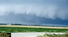
| EF3 | SW of Yuma | Washington, Yuma | CO | 40.12°N 102.81°W | 22:57–23:25 | 6.07 mi (9.77 km) | 161 yd (147 m) |
| At the beginning of the path in Washington County, the tornado shifted a garage at a residence off its foundation and damaged its roof. A metal shack had tin roofing removed, a tin storage container was flipped, power poles and crops were leaned over, and trees were snapped. Damage in this area peaked at high-end EF1. After crossing into Yuma County and overturning some pivots, the tornado strengthened to EF3 intensity, completely destroying a three-car garage of a home, which had parts of its roof removed, doors blown in and windows broken. A nearby large metal event building had its roof destroyed with debris from the structures strewn into nearby cornfields that were partially mowed down. Trees were damaged and power poles were leaned over or snapped as well. The tornado then occluded, snapping more power poles before dissipating west of Yuma.[3][19] Coupled with the EF3 tornado that occurred in Prowers County on June 23, 2023, this event marked the first time that two F3/EF3+ tornadoes touched down in Colorado in the same year since 1993.[20] | |||||||
| EFU | SE of Yuma | Yuma | CO | 40.06°N 102.64°W | 23:30–23:46 | 5.28 mi (8.50 km) | 200 yd (180 m) |
| A multiple-vortex tornado was observed moving between County Roads 34 and 29 across open land. No damage was reported.[21] | |||||||
| EF0 | S of Yuma | Yuma | CO | 39.90°N 102.72°W | 00:04–00:08 | 1.67 mi (2.69 km) | 193 yd (176 m) |
| Storm chasers observed a tornado that did damage to corn.[21] | |||||||
| EFU | NE of Cope | Yuma | CO | 39.86°N 102.69°W | 00:19–00:22 | 1.01 mi (1.63 km) | 150 yd (140 m) |
| Multiple chasers observed a brief rope tornado that appeared to say over an open field causing no damage.[21] | |||||||
| EFU | NE of Cope | Yuma | CO | 39.81°N 102.66°W | 00:23–00:32 | 0.93 mi (1.50 km) | 75 yd (69 m) |
| Given the southeast movement of the storm, the tornado may have crossed CR J. The tornado remained in open fields, so no damage was observed.[21] | |||||||
| EFU | W of Idalia | Yuma | CO | 39.69°N 102.51°W | 01:00–01:14 | 0.45 mi (0.72 km) | |
| The tornado faded and reappeared more than once during its lifetime. The tornado ended before crossing CR S. No damage was observed due to the tornado remaining over a field.[21] | |||||||
| EF2 | SW of Idalia | Yuma, Kit Carson | CO | 39.61°N 102.40°W | 01:25–01:47 | 5.81 mi (9.35 km) | 150 yd (140 m) |
| A strong tornado touched down southwest of Idalia overturning an irrigation pivot. The tornado then crossed County Road 2 where nine power poles were snapped, earning the tornado an EF2 rating.[21] | |||||||
| EFU | SSE of Kanorado | Sherman | KS | 39.30°N 102.02°W | 03:17–03:24 | 1.3 mi (2.1 km) | 75 yd (69 m) |
| A few grass swirls with small dead tree limbs were found on an abandoned property.[21] | |||||||
Non-tornadic impacts
Over 1,000 preliminary wind reports were recorded as severe weather impacted the East Coast of the United States on August 7.[6] This led to Widespread transit and Amtrak train delays in both the Northeast megalopolis, Great Lakes and Southeastern United States.[22]
A Major League Baseball game between the Washington Nationals and the Philadelphia Phillies was postponed on August 7 due to the inclement weather.[23] The baseball game between the New York Mets and Chicago Cubs saw a 2-hour and 9 minute delay due to the rain.[24] A Carly Rae Jepsen concert at The Rooftop at Pier 17 in New York City was cancelled due to a lightning storm.[25] A 2023 Leagues Cup match between the Philadelphia Union and New York Red Bulls was postponed by a day.[26] Several state governors, including Maryland governor Wes Moore, New York governor Kathy Hochul, and West Virginia governor Jim Justice urged people to stay alert, and to be prepared.[27] Hochul's administration and local officials in New York were on stand-by for clean-up and response efforts, while Justice declared a State of Preparedness for all counties in West Virginia.[27][28] Schools in Tennessee and Georgia were closed.[29][30][31] Tornado watches and warnings were posted across ten states from Tennessee to New York, covering 29.5 million people.[32] U.S. government offices in Washington, D.C. were closed early in anticipation of severe weather.[33] Joe Biden's trip to the western United States was delayed 90 minutes.[32]
A rare flash flood emergency was issued for Cambridge, Maryland, where flood damage and water rescues occurred as 4 inches (100 mm) of rain fell in two hours.[34][35] Power lines fell in Westminster, Maryland, including on MD 140, trapping more than forty people in their cars after live power lines fell behind and in front of vehicles.[36][37] Montgomery Parks closed Sligo Creek Parkway and a road because of the threat for flooding, and damaging winds, causing trees to fall. A U.S. District Court sentencing was postponed due to severe weather, and tolls on I-66 reached nearly thirty dollars.[11] Extra trains were operated by the Washington Metro to assist in people to get to their residences, and the Emergency Operations Center was activated.[11][38] Train stations also operated an extra hour because Beyoncé's tour paid $100,000 to do so for fans to arrive at FedExField in Landover, Maryland, and to help people get home.[39] FedexField was also under a "shelter in place" order due to the imminent severe weather threat, and it was lifted nearly two hours later.[40][41] Despite the severe weather, a Pink concert was allowed to proceed, but inclement weather forced fans at Nationals Park to remain at the concourse.[11] Fallen trees trapped hikers and campers at Fall Creek Falls State Park, and forced the park to close.[42] Damage occurred in eastern Kentucky and western North Carolina.[43] Flooding occurred in numerous towns in Massachusetts, including North Andover, Lowell, and Needham.[44] The Knoxville Utilities Board in Knoxville, Tennessee, stated that the damage across eastern Tennessee was "widespread and extensive".[45]
More than nine airports issued ground stops, including LaGuardia Airport, Ronald Reagan Washington National Airport, Hartsfield–Jackson Atlanta International Airport, and Baltimore/Washington International Airport.[46] More than 1,700 flights were cancelled and nearly 9,000 were delayed across eastern United States airports impacted by severe weather.[47][48] At least one million power outages occurred across the eastern United States, and two people were killed.[49][50]
On August 8, the storms in Colorado produced a 5.25 in (13.3 cm) hailstone in Kirk that became the largest hailstone in state history in terms of diameter.[51]
The American Red Cross were prepared to respond if conditions were necessary.[52]
See also
Notes
- All dates are based on the local time zone where the tornado touched down; however, all times are in Coordinated Universal Time for consistency.
References
- National Centers for Environmental Information; National Oceanic and Atmospheric Administration (11 September 2023). "U.S. Billion-Dollar Weather and Climate Disasters 1980-2023" (PDF). NOAA NCEI Billion-Dollar Weather and Climate Disasters. United States Department of Commerce. p. 1. Archived (PDF) from the original on 11 September 2023. Retrieved 11 September 2023.
- 2 dead after massive severe weather outbreak in eastern US, AccuWeather, August 7, 2023
- "DAT". apps.dat.noaa.gov. Retrieved 13 July 2023.
- "SPC Storm Reports for 08/08/23". www.spc.noaa.gov. Storm Prediction Center. Archived from the original on August 8, 2023. Retrieved August 9, 2023.
- "2 tornadoes tear through Yuma County, destroying property - CBS Colorado". www.cbsnews.com. 2023-08-10. Retrieved 2023-08-10.
- "SPC Severe Weather Event Review for Monday August 07, 2023". www.spc.noaa.gov. Retrieved 2023-08-09.
- "Anderson 15-year-old dies while visiting grandparent during Monday's severe storms". Independent Mail. Retrieved 2023-08-09.
- Thornton, William (2023-08-08). "Man killed by lightning strike in Alabama industrial park 'forever a king'". al. Retrieved 2023-08-09.
- "Storm Prediction Center Aug 7, 2023 1630 UTC Day 1 Convective Outlook". www.spc.noaa.gov. Retrieved 2023-08-09.
- "Two killed as severe storms rip through eastern US". BBC News. 2023-08-08. Retrieved 2023-08-09.
- "Some severe storms sweep through D.C. area, but not as bad as feared". Washington Post. 2023-08-07. Retrieved 2023-08-09.
- Service, NOAA's National Weather. "Weather Prediction Center". www.wpc.ncep.noaa.gov. Retrieved 2023-08-09.
- "NWS St. Louis Twitter". twitter.com. Retrieved 5 Aug 2023.
- "Public Information Statement". mesonet.agron.iastate.edu. Retrieved 8 August 2023.
- "...NWS Damage Survey for 08/07/2023 Tornado Event..." Iowa Environment Mesonet. National Weather Service. Retrieved 10 August 2023.
- "Public Information Statement". mesonet.agron.iastate.edu. Retrieved 8 August 2023.
- "NWS Boston Twitter". twitter.com. Retrieved 8 August 2023.
- "NWS Boston Twitter". twitter.com. Retrieved 8 August 2023.
- "2 tornadoes tear through Yuma County, destroying property - CBS Colorado". www.cbsnews.com. August 10, 2023.
- "U.S. TORNADOES* (1950-2022)". Storm Prediction Center. Storm Prediction Center. Retrieved 14 August 2023.
- https://apps.dat.noaa.gov/StormDamage/DamageViewer/
- "Excessive Heat and Weather Disruptions May Cause Northeast Corridor Delays:". Twitter. Retrieved 20 August 2023.
- Dougherty, Jessie (August 7, 2023). "Postponement leaves Nats, Phillies with straight doubleheader Tuesday". The Washington Post.
- Alonso drives in 6 as Mets rout Cubs after rain delay, CBS New York, August 8, 2023
- "Carly Rae Jepsen Tells Crowd 'No One's Getting Electrocuted Tonight' After NYC Show Canceled Due to Lightning". Peoplemag. Retrieved 2023-08-09.
- New York Red Bulls Round 16 Matchup in 2023 Leagues Cup Against Philadelphia Union Postponed, New York Red Bulls, August 7, 2023
- Chowdhury, Aditi Sangal,Elise Hammond,Maureen (2023-08-07). "August 7, 2023 Millions in Eastern US face risk of severe weather". CNN. Retrieved 2023-08-09.
{{cite web}}: CS1 maint: multiple names: authors list (link) - "Governor issues State of Preparedness ahead of severe storms". governor.wv.gov. Retrieved 2023-08-09.
- Jordan, Avery (2023-08-08). "East Tennessee schools closed due to severe weather". WVLT. Retrieved 2023-08-09.
- Staff, Local 3 News (2023-08-07). "Local school systems announce early dismissals on Monday due to severe weather threat". Local3News.com. Retrieved 2023-08-09.
- Hood, Brittany. "Severe Weather Update - August 7, 2023". DeKalb County School District. Retrieved 2023-08-09.
- "Severe weather in East kills at least 2, hits airlines schedules hard and causes widespread power outages - CBS News". www.cbsnews.com. 2023-08-08. Retrieved 2023-08-09.
- Shepardson, David (2023-08-08). "Washington shuts US government offices due to threatening weather". Reuters. Retrieved 2023-08-09.
- Curtis, Sean (2023-08-07). "Flood Emergency in Cambridge". WBOC TV. Retrieved 2023-08-09.
- "Cambridge recovering from Monday's flood". 47abc. 2023-08-08. Retrieved 2023-08-09.
- "Cleanup underway after storm knocks down utility poles along busy Westminster road - CBS Baltimore". www.cbsnews.com. 2023-08-08. Retrieved 2023-08-09.
- Yan, Nouran Salahieh,Holly (2023-08-08). "Tens of thousands still without power after deadly storms as a new wave of severe weather and flooding hits". CNN. Retrieved 2023-08-09.
{{cite web}}: CS1 maint: multiple names: authors list (link) - "Metro is running lots of service getting everyone where they need to go before the severe weather hits". Twitter. Retrieved 2023-08-09.
- "Beyoncé's tour paid D.C. Metro $100,000 to keep trains running after bad weather delayed concert". NBC News. 2023-08-08. Retrieved 2023-08-09.
- "Beyoncé's Team Covers $100K Cost to Keep Maryland Trains Running After Rain Delayed Renaissance Tour Stop". Peoplemag. Retrieved 2023-08-09.
- "https://twitter.com/FedExField/status/1688319086747340800". Twitter. Retrieved 2023-08-09.
{{cite web}}: External link in|title= - "Severe weather traps hikers, campers at Fall Creek Falls State Park". WKRN News 2. 2023-08-08. Retrieved 2023-08-09.
- "Severe weather in WNC causes thousands to lose power. NWS surveying for possible tornadoes". The Asheville Citizen Times. Retrieved 2023-08-09.
- Yablonski, Steven (2023-08-08). "Severe storms roll through Plains, Southeast on Tuesday". FOX Weather. Retrieved 2023-08-09.
- "Thousands without power after severe weather kills 2, disrupts thousands of flights". USA TODAY. Retrieved 2023-08-09.
- Aratani, Lori; Duncan, Ian (August 7, 2023). "FAA pauses flights as East Coast storms disrupt travel". The Washington Post.
- Revell, Eric (2023-08-08). "Thousands of flights delayed or canceled as severe weather hits US". FOXBusiness. Retrieved 2023-08-09.
- Knutson, Jacob; Falconer, Rebecca (August 8, 2023). "Severe storms batter eastern and southern U.S., killing two people". Axios.
- "Eastern U.S. Thunderstorms: Severe Weather Hits Eastern U.S." 2023-08-07. Retrieved 2023-08-09.
- "News Wrap: Storm system blasts eastern U.S. with severe weather". PBS NewsHour. 2023-08-08. Retrieved 2023-08-09.
- Erdman, Johnathon (September 27, 2023). "Colorado Hailstone Confirmed As New State Record". Weather Underground. Retrieved October 21, 2023.
- "Severe Weather Still a Threat ─ Follow these Safety Steps". www.redcross.org. Retrieved 2023-08-09.